
-
Federal
OCO-3 Level 1A collated, parsed, calibration data V11 (OCO2_L1aIn_Pixel) at GES DISC
National Aeronautics and Space Administration —
Version 11 is the current version of the data set. Older versions will no longer be available and are superseded by Version 11. The Orbiting Carbon Observatory is the... -
Federal
MARS EXPRESS SUN MRS 1/2/3 EXTENDED MISSION 8 4233 V1.0
National Aeronautics and Space Administration —
This is a Mars Express Radio Science data set, collected during the extended mission phase 2021-01-01 to 2022-12-31. It is a Solar Conjunction measurement and covers... -
Federal
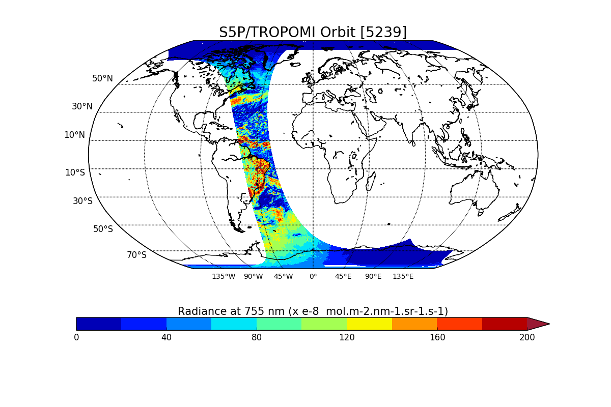
Sentinel-5P TROPOMI Radiance product band 6 (NIR detector) L1B V1 (S5P_L1B_RA_BD6) at GES DISC
National Aeronautics and Space Administration —
Starting from August 6th in 2019, Sentinel-5P TROPOMI along-track high spatial resolution (~5.5km at nadir) has been implemented. For data after August 6th of 2019,... -
Federal
MODIS/Aqua Cloud Properties COSP Level 3 monthly, 1x1 deg. grid
National Aeronautics and Space Administration —
The MODIS/Aqua Cloud Properties COSP Level 3 monthly, 1x1 degree grid product is a new L3 CLDPROP COSP Cloud product with short-name CLDPROPCOSP_M3_MODIS_Aqua. It... -
Federal
MODIS/Terra+Aqua Nadir BRDF-Adjusted Reflectance Daily L3 Global 500 m SIN Grid
National Aeronautics and Space Administration —
The MODIS Near Real Time (NRT) Combined Aqua and Terra Nadir BRDF-Adjusted Reflectance, MCD43A4N, Nadir Bidirectional Reflectance Distribution Function... -
Federal
Carbon Monitoring System Lake Superior Primary Production Yearly V1 (CMSLakeSuperiorPPY) at GES DISC
National Aeronautics and Space Administration —
Yearly Average primary production/carbon fixation data for Lake Superior. The primary production data is derived using MODIS imagery with model data. The NASA Carbon... -
Federal
TRACE-A DC-8 Remotely Sensed Differential Absorption Lidar (DIAL) Data
National Aeronautics and Space Administration —
TRACE-A_AircraftRemoteSensing_DC8_DIAL_Data is the remotely sensed Differential Absorption Lidar (DIAL) data collected onboard the DC-8 aircraft during the Transport... -
Federal
NRT AMSR2 Unified L3 Daily 12.5 km Brightness Temperature & Sea Ice Concentration V4
National Aeronautics and Space Administration —
The Advanced Microwave Scanning Radiometer 2 (AMSR2) instrument on the Global Change Observation Mission - Water 1 (GCOM-W1) provides global passive microwave... -
Federal
Daymet: Station-Level Inputs and Cross-Validation for North America, Version 4 R1
National Aeronautics and Space Administration —
This dataset reports the station-level daily weather observation data and the corresponding cross-validation results for three Daymet model parameters: minimum... -
Federal
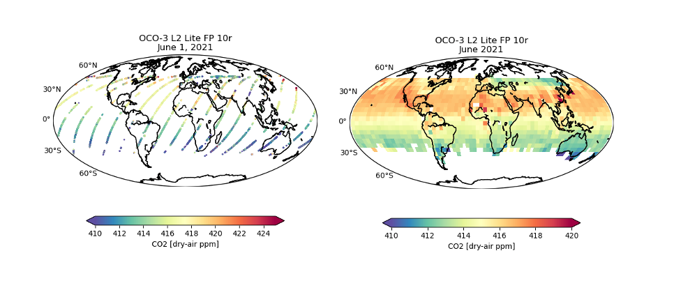
OCO-3 Level 2 bias-corrected XCO2 and other select fields from the full-physics retrieval aggregated as daily files, Retrospective processing V11r (OCO3_L2_Lite_FP) at GES DISC
National Aeronautics and Space Administration —
Version 11r is the current version of the data set. Older versions will no longer be available and are superseded by Version 11r. The Orbiting Carbon Observatory -3... -
Federal
Amazon Forest Structure from Airborne Lidar, ED2 Initial Condition Files, 2016
National Aeronautics and Space Administration —
This dataset provides initial condition files for initializing the Ecosystem Demography Model (ED2). This dataset holds regional forest structure characteristics... -
Federal
Aqua MODIS Level-3 Global Binned 11µm Nighttime Sea Surface Temperature (NSST) - Near Real-time (NRT) Data, version R2019.0
National Aeronautics and Space Administration —
The Ocean Biology DAAC produces near real-time (quicklook) products using the best-available combination of ancillary data from meteorological and ozone data. As... -
Federal
Aqua MODIS Level-2 Regional 4µm Day/Night Sea Surface Temperature (SST4) - Near Real-time (NRT) Data, version R2019.0
National Aeronautics and Space Administration —
The Ocean Biology DAAC produces near real-time (quicklook) products using the best-available combination of ancillary data from meteorological and ozone data. As... -
Federal
Aquarius CAP Level 3 Wind Speed Standard Mapped Image 7-Day Data V5.0
National Aeronautics and Space Administration —
Version 5.0 Aquarius CAP Level 3 products are the fourth release of the AQUARIUS/SAC-D mapped salinity and wind speed data based on the Combined Active Passive (CAP)... -
Federal
Aquarius Celestial Sky Microwave Emission Map Ancillary Dataset V1.0
National Aeronautics and Space Administration —
This datasets contains three maps of L-band (wavelength = 21 cm) brightness temperature of the celestial sky ("Galaxy") used in the processing of the NASA Aquarius... -
Federal
NAMMA CVI CLOUD CONDENSED WATER CONTENT V1
National Aeronautics and Space Administration —
In the NAMMA CVI Cloud Condensed Water Content dataset the counterflow virtual impactor (CVI) was used to measure condensed water content (liquid water or ice in... -
Federal
CLPX-Airborne: Infrared Orthophotography and Lidar Topographic Mapping, Version 1
National Aeronautics and Space Administration —
The data set consists of color infrared orthophotography (TerrainVision® - High resolution Topographic Mapping & Aerial Photography, with 6-inch pixel... -
Federal
ALOS PALSAR Level 1.5 Product
National Aeronautics and Space Administration —
ALOS PALSAR Level 1.5 -
Federal
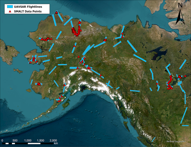
ABoVE: Soil Moisture and Active Layer Thickness in Alaska, USA and Canada, 2005-2022
National Aeronautics and Space Administration —
This dataset provides soil thaw depth and moisture measurements and dielectric properties measured by different research teams at sites in Alaska, U.S., and the... -
Federal
AIRS/Aqua L1B Near Real Time (NRT) AMSU (A1/A2) geolocated and calibrated brightness temperatures V005 (AIRABRAD_NRT) at GES DISC
National Aeronautics and Space Administration —
The AMSU-A Level 1B Near Real Time (NRT) product (AIRABRAD_NRT_005) differs from the routine product (AIRABRAD_005) in 2 ways to meet the three hour latency...

Official websites use .gov
A
.gov website belongs to an official government
organization in the United States.
Secure .gov websites use HTTPS
A
lock (
) or https:// means you’ve safely connected to
the .gov website. Share sensitive information only on official,
secure websites.