
-
Federal
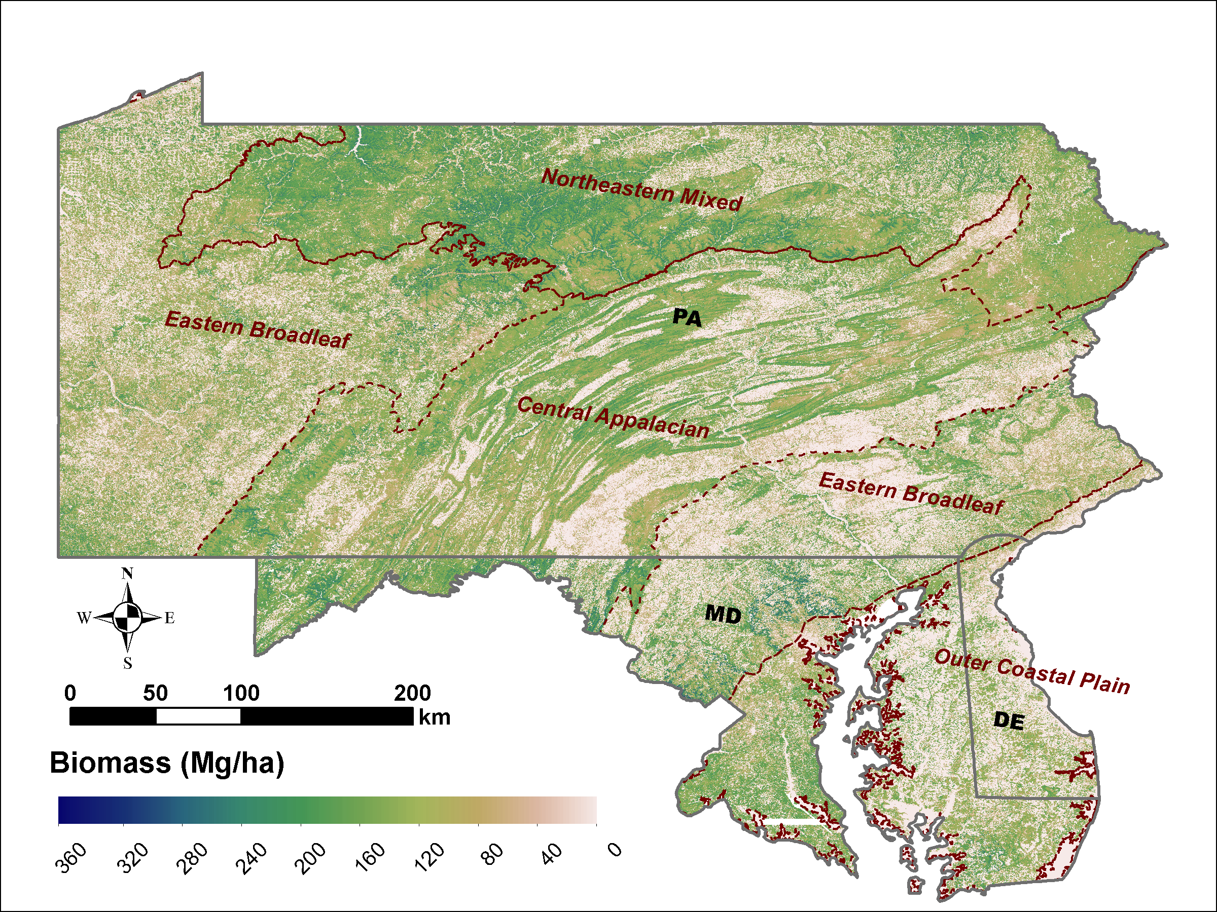
LiDAR Derived Biomass, Canopy Height and Cover for Tri-State (MD, PA, DE) Region, V2
National Aeronautics and Space Administration —
This dataset provides 30-meter gridded estimates of aboveground biomass (AGB), forest canopy height, and canopy coverage for Maryland, Pennsylvania, and Delaware in... -
Federal
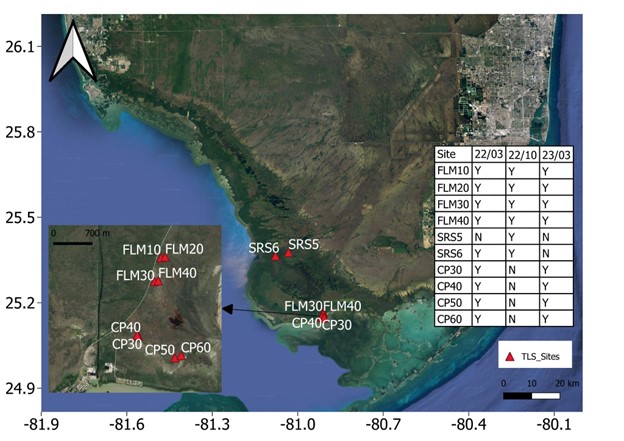
Blueflux: Terrestrial Lidar Scans of Mangrove Forests, Everglades, FL, USA, 2022-2023
National Aeronautics and Space Administration —
This dataset contains point clouds of three-dimensional (3D) mangrove forest structure and volume collected from 10 sites in Everglades National Park, Florida. Data... -
Federal
DISCOVER-AQ Maryland Deployment Edgewood Ground Site Data
National Aeronautics and Space Administration —
DISCOVERAQ_Maryland_Ground_Edgewood_Data contains data collected at the Edgewood ground site during the Maryland (Baltimore-Washington) deployment of NASA's DISCOVER-... -
Federal
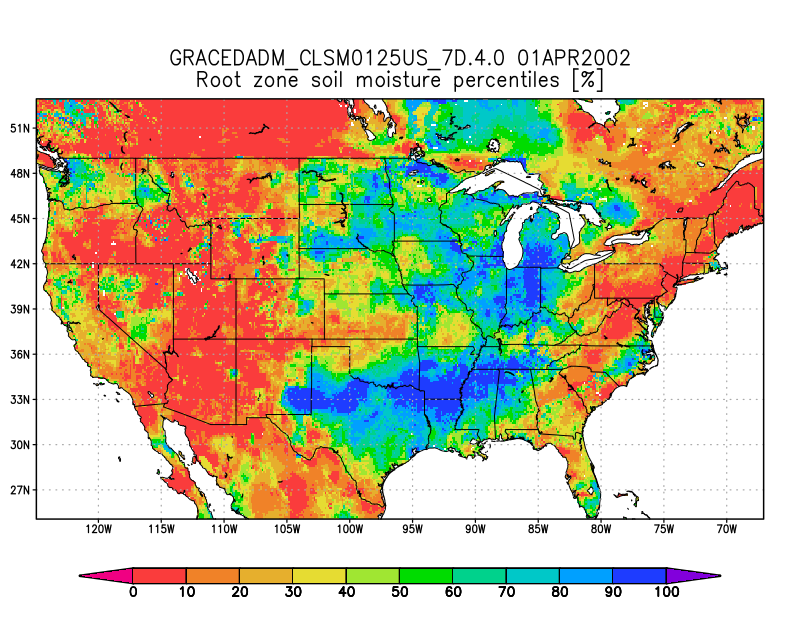
Groundwater and Soil Moisture Conditions from GRACE and GRACE-FO Data Assimilation L4 7-days 0.125 x 0.125 degree U.S. V4.0 (GRACEDADM_CLSM0125US_7D) at GES DISC
National Aeronautics and Space Administration —
Scientists at NASA Goddard Space Flight Center generate groundwater and soil moisture drought indicators each week. They are based on terrestrial water storage... -
Federal
Ground-Based Global Navigation Satellite System (GNSS) Compact Observation Data (30-second sampling, daily, 24 hour files) from NASA CDDIS
National Aeronautics and Space Administration —
This dataset consists of ground-based Global Navigation Satellite System (GNSS) Compact Observation Data (30-second sampling, daily, 24 hour files) from the NASA... -
Federal
ASTER Expedited L1B Registered Radiance at the Sensor V003
National Aeronautics and Space Administration —
The Advanced Spaceborne Thermal Emission and Reflection Radiometer (ASTER) Expedited Level 1B Registered Radiance at the Sensor global data product is radiometrically... -
Federal
SWOT Level 2 Nadir Altimeter Geophysical Data Record with Waveforms - GDR Version D
National Aeronautics and Space Administration —
The SWOT Level 2 Nadir Altimeter Geophysical Data Record (GDR) with Waveforms dataset produced by the Surface Water and Ocean Topography (SWOT) mission provides sea... -
Federal
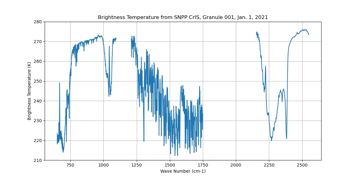
Sounder SIPS: Sun Synchronous 13:30 orbit Climate Hyperspectral InfraRed Product (CHIRP): Calibrated Radiances from S-NPP, V2 (SNDR13CHRP1SNCal) at GES DISC
National Aeronautics and Space Administration —
The Climate Hyperspectral Infrared Radiance Product (CHIRP) is a Level 1 radiance product derived from Atmospheric Infrared Sounder (AIRS) on EOS-AQUA and the Cross-... -
Federal
MODIS/Terra+Aqua Land Surface BRF Daily L2G Global 500m and 1km SIN Grid V061
National Aeronautics and Space Administration —
The MCD19A1 Version 6.1 data product is a Moderate Resolution Imaging Spectroradiometer (MODIS) Terra and Aqua combined Land Surface Bidirectional Reflectance Factor... -
Federal
BOUSSOLE project
National Aeronautics and Space Administration —
The purpose of the BOUSSOLE project is to establish a time series of optical properties in oceanic waters, in support to bio-optics research, to calibration of ocean... -
Federal
HLS Landsat Operational Land Imager Surface Reflectance and TOA Brightness Daily Global 30m v2.0
National Aeronautics and Space Administration —
The Harmonized Landsat Sentinel-2 (HLS) project provides consistent surface reflectance (SR) and top of atmosphere (TOA) brightness data from a virtual constellation... -
Federal
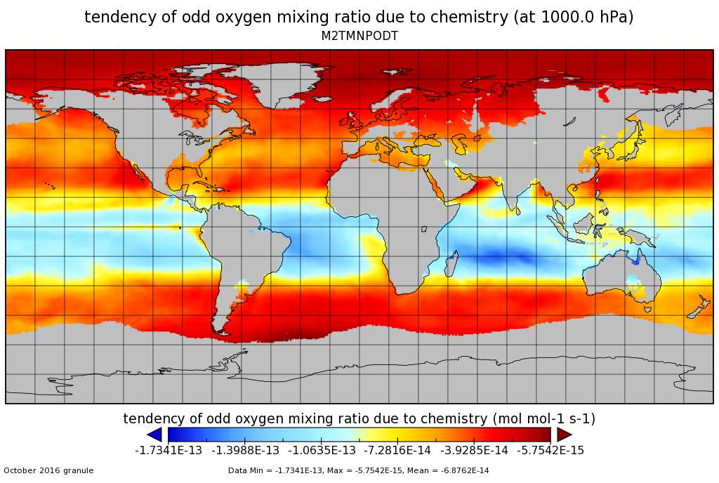
MERRA-2 tavgM_3d_odt_Np: 3d,Monthly mean,Time-Averaged,Pressure-Level,Assimilation,Ozone Tendencies 0.625 x 0.5 degree V5.12.4 (M2TMNPODT) at GES DISC
National Aeronautics and Space Administration —
M2TMNPODT (or tavgM_3d_odt_Np) is a 3-dimensional monthly mean data collection in Modern-Era Retrospective analysis for Research and Applications version 2 (MERRA-2).... -
Federal
GLDAS Noah Land Surface Model L4 monthly 0.25 x 0.25 degree V2.0 (GLDAS_NOAH025_M) at GES DISC
National Aeronautics and Space Administration —
NASA Global Land Data Assimilation System Version 2 (GLDAS-2) has three components: GLDAS-2.0, GLDAS-2.1, and GLDAS-2.2. GLDAS-2.0 is forced entirely with the... -
Federal
CPEX-AW Dropsonde Data
National Aeronautics and Space Administration —
CPEXAW-Dropsondes_1 is the dropsonde data files collected during the Convective Processes Experiment - Aerosols & Winds (CPEX-AW). Data collection for this... -
Federal
JERS-1 Synthetic Aperture Radar, 100-m Mosaics, South America: 1995-1996, R1
National Aeronautics and Space Administration —
This data set provides ~100-m resolution image mosaics of South America acquired during the low flood season between September and December 1995 and during the high... -
Federal
DC3 In-Situ DC-8 Aircraft Aerosol Data
National Aeronautics and Space Administration —
DC3_Aerosol_AircraftInSitu_DC8_Data are in-situ aerosol data collected onboard the DC-8 aircraft during the Deep Convective Clouds and Chemistry (DC3) field campaign.... -
Federal
GLDAS Noah Land Surface Model L4 monthly 1.0 x 1.0 degree V2.0 (GLDAS_NOAH10_M) at GES DISC
National Aeronautics and Space Administration —
NASA Global Land Data Assimilation System Version 2 (GLDAS-2) has three components: GLDAS-2.0, GLDAS-2.1, and GLDAS-2.2. GLDAS-2.0 is forced entirely with the... -
Federal
MASTER: FireSense, California and Southern US, Spring 2025
National Aeronautics and Space Administration —
This dataset includes Level 1B (L1B) and Level 2 (L2) data products from the MODIS/ASTER Airborne Simulator (MASTER) instrument. The spectral data were collected as... -
Federal
ACCLIP WB-57 Aircraft In-situ Trace Gas Data
National Aeronautics and Space Administration —
ACCLIP_TraceGas_AircraftInSitu_WB57_Data is the in-situ trace gas data collection during the Asian Summer Monsoon Chemical & Climate Impact Project (ACCLIP). Data...

Official websites use .gov
A
.gov website belongs to an official government
organization in the United States.
Secure .gov websites use HTTPS
A
lock (
) or https:// means you’ve safely connected to
the .gov website. Share sensitive information only on official,
secure websites.