

120 datasets found
-
Federal
Kilauea 2018 lower East Rift Zone eruption - fissure 22 lava flow
Department of the Interior —
The 2018 lower East Rift Zone eruption of Kilauea Volcano began in the late afternoon of 3 May, with fissure 1 opening and erupting lava onto Mohala Street in the... -
Federal
Maui Aeromagnetic Survey
Department of Energy —
Map, image, and data files, and a summary report of a high-resolution aeromagnetic survey of southern Maui, Hawai'i completed by EDCON-PRJ, Inc. for Ormat Nevada Inc... -
Federal
Island of Hawaii bird, mosquito, and avian malaria infection data 2001-2004
Department of the Interior —
This data publication contains data files collected as part of a field, laboratory, and modeling effort aimed at uncovering ecological drivers of avian malaria... -
Federal
Video products collected during the second leg of the Gulf of Alaska 2002 Expedition to study several unexplored seamounts in the Gulf of Alaska on R/V Atlantis from 2002-07-05 to 2002-07-15
National Oceanic and Atmospheric Administration, Department of Commerce —
This dataset contains video products from R/V Atlantis and Alvin submersible from the second leg of the Gulf of Alaska 2002 Expedition headed south from Kodiak,... -
Federal
Digital elevation model of Kilauea Volcano, Hawai'i, based on July 2019 airborne lidar surveys
Department of the Interior —
The 2018 eruption of Kilauea Volcano on the Island of Hawai'i saw the collapse of a new, nested caldera at the volcano's summit, and the inundation of 35.5 square... -
Federal
Kilauea 2018 lower East Rift Zone eruption - fissures 06 and 13 lava flow
Department of the Interior —
The 2018 lower East Rift Zone eruption of Kilauea Volcano began in the late afternoon of 3 May, with fissure 1 opening and erupting lava onto Mohala Street in the... -
Federal
Map of Validation of Innovative Exploration Technologies for Newberry Volcano
Department of Energy —
A map showing location of wells permitted, drilled and seismic test, as part of validation of innovative exploration technologies done for the Newberry Volcano... -
Federal
Thermal maps of the 2018 lower East Rift Zone eruption of Kilauea Volcano, Island of Hawai`i
Department of the Interior —
The 2018 eruption of Kīlauea Volcano included both a large effusive eruption on the lower East Rift Zone and associated collapse and subsidence of the caldera floor... -
Federal
Historical video footage of Mount St. Helens volcano, March 28-May 17, 1980
Department of the Interior —
This data release contains digital video files from the USGS of Mount St. Helens volcano in the months leading up to the cataclysmic eruption on May 18, 1980 as well... -
Federal
Kilauea 2018 lower East Rift Zone eruption - lava flows overlap
Department of the Interior —
The 2018 lower East Rift Zone eruption of Kilauea Volcano began in the late afternoon of 3 May, with fissure 1 opening and erupting lava onto Mohala Street in the... -
Federal
Geospatial database of the 2018 lower East Rift Zone eruption of Kilauea Volcano, Hawai'i
Department of the Interior —
The 2018 lower East Rift Zone eruption of Kilauea Volcano began in the late afternoon of 3 May, with fissure 1 opening and erupting lava onto Mohala Street in the... -
State
High Hazard Zone
State of Oregon —
Volcanic eruptions are most likely to occur in the Pacific Rim states, which include Oregon. The primary danger area around a volcano covers an approximately 20-mile... -
Federal
Kilauea 2018 lower East Rift Zone eruption - lava flow footprint
Department of the Interior —
The 2018 lower East Rift Zone eruption of Kilauea Volcano began in the late afternoon of 3 May, with fissure 1 opening and erupting lava onto Mohala Street in the... -
Federal
Cook Inlet and Kenai Peninsula, Alaska ESI: VOLCANOS (Volcano Points)
National Oceanic and Atmospheric Administration, Department of Commerce —
This data set contains the locations of volcanos in Cook Inlet and Kenai Peninsula, Alaska. Vector points in the data set represent the location of the volcanos.... -
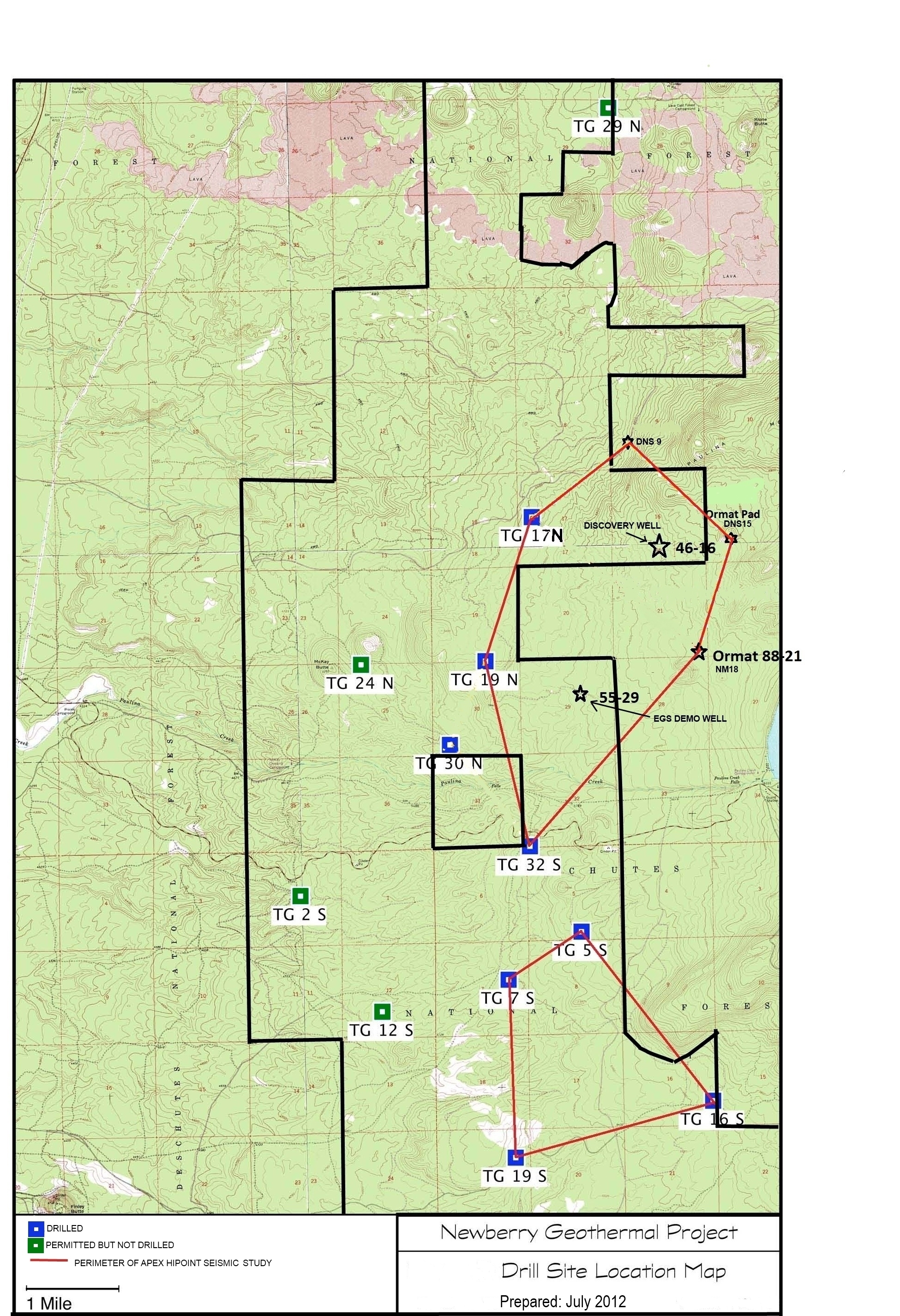
Federal
Validation of Innovative Exploration Technologies for Newberry Volcano: Drill Site Location Map
Department of Energy —
Newberry seeks to explore "blind" (no surface evidence) convective hydrothermal systems associated with a young silicic pluton on the flanks of Newberry Volcano. This... -
Federal
Kilauea 2018 lower East Rift Zone eruption - fissure 12 lava flow
Department of the Interior —
The 2018 lower East Rift Zone eruption of Kilauea Volcano began in the late afternoon of 3 May, with fissure 1 opening and erupting lava onto Mohala Street in the... -
Federal
Validation of Innovative Exploration Technologies for Newberry Volcano: LiDAR of Newberry Volcano
Department of Energy —
Validation of Innovative Exploration Technologies for Newberry Volcano: LiDAR of Newberry Volcano 2012 -
Federal
Site Locations for Kawaikoi Stream and Volcano Village
Department of the Interior —
Mosquito-borne avian malaria is a key limiting factor on Hawaiian forest bird populations. Preservation of endemic forest birds and restoration of Hawaiian forest... -
Federal
Video products collected during the first leg of the Gulf of Alaska 2002 Expedition to study several unexplored seamounts in the Gulf of Alaska on R/V Atlantis from 2002-06-22 to 2002-07-15
National Oceanic and Atmospheric Administration, Department of Commerce —
This dataset contains video products from R/V Atlantis and Alvin submersible from the first leg of the Gulf of Alaska 2002 Expedition headed north from Astoria,... -
Federal
SedCam Model Calibration Imagery Acquired June 2020 to September 2021 at East Branch Brandywine Creek (USGS 01480870)
Department of the Interior —
Two empirical simple linear regression models were developed from SedCam imagery and concurrent physical sediment samples over a 20-month period at the East Branch...
120 datasets found