
-
Federal
AMSR/ADEOS-II L1A Raw Observation Counts V003
National Aeronautics and Space Administration —
The AMSR/ADEOS-II L1A Raw Observing Counts (AMSR-L1A) data set was processed from Level 0 science packet data by the JAXA Earth Observation Center (EOC) in Japan. -
Federal
TRMM TROPICAL CYCLONE PRECIPITATION FEATURE (TCPF) DATABASE - LEVEL 1 V1
National Aeronautics and Space Administration —
The TRMM Cyclone Precipitation Feature (TCPF) Database - Level 1 provides Tropical Rainfall Measuring Mission (TRMM)-based tropical cyclone data in a common framework... -
Federal
SMAP L3 Radar/Radiometer Global Daily 9 km EASE-Grid Soil Moisture V003
National Aeronautics and Space Administration —
This Level-3 (L3) soil moisture product provides a daily composite of global land surface conditions retrieved by both the Soil Moisture Active Passive (SMAP) radar... -
Federal
SMAP L1C Radiometer Half-Orbit 36 km EASE-Grid Brightness Temperatures V006
National Aeronautics and Space Administration —
This Level-1C (L1C) product contains calibrated and geolocated brightness temperatures acquired by the Soil Moisture Active Passive (SMAP) radiometer during 6:00 a.m.... -
Federal
TROPICS07 L2A Unified Resolution Brightness Temperatures V0.2
National Aeronautics and Space Administration —
The "Time-Resolved Observations of Precipitation structure and storm Intensity with a Constellation of Smallsats" (TROPICS) mission has a goal of providing nearly... -
Federal
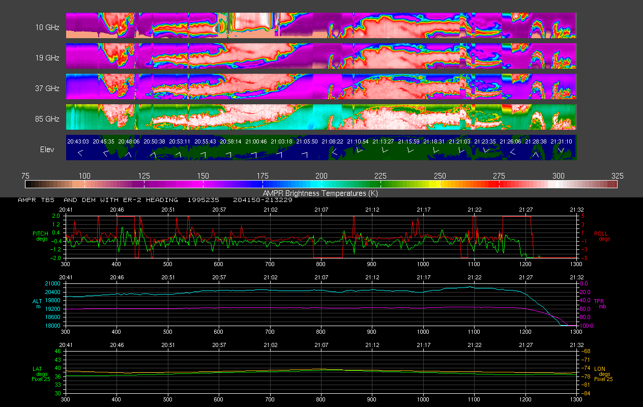
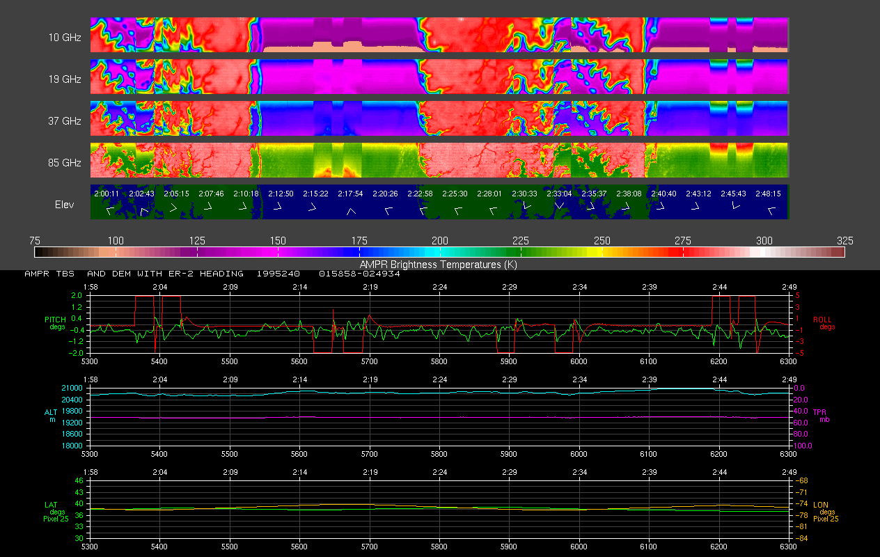
AMPR BRIGHTNESS TEMPERATURE CAMEX-2 V2
National Aeronautics and Space Administration —
The Advanced Microwave Precipitation Radiometer (AMPR) was deployed during the Convection and Moisture Experiment 2 (CAMEX-2). AMPR data were collected at a... -
Federal
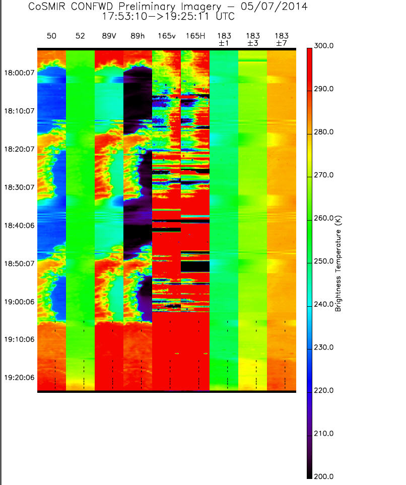
GPM GROUND VALIDATION CONICAL SCANNING MILLIMETER-WAVE IMAGING RADIOMETER (COSMIR) IPHEx V1
National Aeronautics and Space Administration —
The GPM Ground Validation Conical Scanning Millimeter-wave Imaging Radiometer (CoSMIR) IPHEx dataset consists of brightness temperatures from 9 channels as measured... -
Federal
SMAPVEX12 PALS Brightness Temperature Data V001
National Aeronautics and Space Administration —
This data set contains brightness temperatures obtained by the Passive Active L-band System (PALS) aircraft instrument. The data were collected as part of SMAPVEX12,... -
Federal
AMSR-E/AMSR2 Unified L3 Daily 12.5 km Brightness Temperatures, Sea Ice Concentration, Motion & Snow Depth Polar Grids V001
National Aeronautics and Space Administration —
This data set reports average daily horizontally and vertically polarized brightness temperatures; sea ice concentrations; and snow depths over sea ice on 12.5 km... -
Federal
SMAP/Sentinel-1 L2 Radiometer/Radar 30-Second Scene 3 km EASE-Grid Soil Moisture V003
National Aeronautics and Space Administration —
This Level-2 (L2) soil moisture product provides estimates of land surface conditions retrieved by both the Soil Moisture Active Passive (SMAP) radiometer during 6:00... -
Federal
SMAPVEX16 Manitoba PALS Brightness Temperature and Soil Moisture Data V001
National Aeronautics and Space Administration —
This product contains data derived from permanent in situ soil stations and observations by the Passive Active L-band System (PALS) microwave aircraft instrument. The... -
Federal
ADVANCED MICROWAVE SOUNDING UNIT-A (AMSU-A) SWATH FROM NOAA-16 V1
National Aeronautics and Space Administration —
AMSU-A, the Advanced Microwave Sounding Unit, is a 15-channel passive microwave radiometer used to profile atmospheric temperature and moisture from the earth's... -
Federal
Aquarius L2 Swath Single Orbit Soil Moisture V005
National Aeronautics and Space Administration —
This data set contains Level-2 global soil moisture estimates derived from the NASA Aquarius passive microwave radiometer on the Satélite de Aplicaciones Científicas... -
Federal
GPM Ground Validation Composite Satellite Overpasses OLYMPEX V4
National Aeronautics and Space Administration —
The GPM Ground Validation Composite Satellite Overpasses OLYMPEX dataset provides brightness temperature, precipitation, and total column water vapor estimates from... -
Federal
TROPICS03 L2B Neural-network Atmospheric Vertical Temperature & Moisture Profiles V1.0
National Aeronautics and Space Administration —
The "Time-Resolved Observations of Precipitation structure and storm Intensity with a Constellation of Smallsats" (TROPICS) mission has a goal of providing nearly... -
Federal
SMAPVEX08 PALS Brightness Temperature Data V001
National Aeronautics and Space Administration —
This data set contains brightness temperatures obtained by the Passive Active L-band System (PALS) microwave aircraft radiometer instrument as part of the Soil... -
Federal
GPM DPR Ku-band Received Power L1B 1.5 hours 5 km V07 (GPM_PRL1KU) at GES DISC
National Aeronautics and Space Administration —
Version 07 is the current version of the data set. Older versions are no longer available and have been superseded by Version 07. This product contains the calibrated... -
Federal
Data for "Targeted Chemical Pressure Yields Tunable Millimeter-Wave Dielectric "
National Institute of Standards and Technology —
Included here are figures and other relevant data from the paper "Targeted Chemical Pressure Yields Tunable Millimeter-Wave 5G Dielectric with Unparalleled... -
Federal
TROPICS05 L2B Neural-network Atmospheric Vertical Temperature & Moisture Profiles V0.2
National Aeronautics and Space Administration —
The "Time-Resolved Observations of Precipitation structure and storm Intensity with a Constellation of Smallsats" (TROPICS) mission has a goal of providing nearly... -
Federal
SMAP L3 Radiometer Global Daily 36 km EASE-Grid Soil Moisture V009
National Aeronautics and Space Administration —
This Level-3 (L3) soil moisture product provides a composite of daily estimates of global land surface conditions retrieved by the Soil Moisture Active Passive (SMAP)...

Official websites use .gov
A
.gov website belongs to an official government
organization in the United States.
Secure .gov websites use HTTPS
A
lock (
) or https:// means you’ve safely connected to
the .gov website. Share sensitive information only on official,
secure websites.