
-
Federal
Montauk, New York 1/3 arc-second MHW Coastal Digital Elevation Model
National Oceanic and Atmospheric Administration, Department of Commerce —
NOAA's National Geophysical Data Center (NGDC) is building high-resolution digital elevation models (DEMs) for select U.S. coastal regions. These integrated... -
Federal
National Status and Trends, Benthic Surveillance Project Aryl Hydrocarbon Hydrolase (AHH) Data, 1988-1992, National Centers for Coastal Ocean Science
National Oceanic and Atmospheric Administration, Department of Commerce —
In order to determine the current status of and detect any long-term trends in the environmental quality of U.S. nearshore waters, NOAA initiated the National Status... -
Federal
NY/NJ Metro Area, Hudson River, and South Long Island 2016 ESIL (ESI Shoreline Types - Lines)
National Oceanic and Atmospheric Administration, Department of Commerce —
This data set contains vector lines representing coastal habitats of New York, New Jersey, Hudson River, and the south shore of Long Island, classified by their... -
Federal
H12997: NOS Hydrographic Survey , 2017-05-13
National Oceanic and Atmospheric Administration, Department of Commerce —
The National Oceanic and Atmospheric Administration (NOAA) has the statutory mandate to collect hydrographic data in support of nautical chart compilation for safe... -
Federal
NY/NJ Metro Area, Hudson River, and South Long Island 2016 HYDROP (Hydrography Polygons)
National Oceanic and Atmospheric Administration, Department of Commerce —
This data set contains vector polygons representing the coastal shoreline and hydrography used in the creation of the Environmental Sensitivity Index (ESI) for New... -
Federal
National Status and Trends, Benthic Surveillance Project Chemistry Data, 1984-1992, National Centers for Coastal Ocean Science
National Oceanic and Atmospheric Administration, Department of Commerce —
The National Status and Trends (NS&T) Benthic Surveillance Project Chemistry data file reports the trace concentrations of a suite of chemical contaminants in... -
Federal
NOAA ESRI Grid - seafloor hardbottom occurrence predictions model in New York offshore planning area from Biogeography Branch
National Oceanic and Atmospheric Administration, Department of Commerce —
This dataset represents hard bottom occurrence predictions from a spatial model developed for the New York offshore spatial planning area. This model builds upon the... -
Federal
Coastal Resources Atlas: Long Island: INDEX (Index Polygons)
National Oceanic and Atmospheric Administration, Department of Commerce —
This data set contains vector polygons representing the boundaries of all hardcopy cartographic products and other map and digital data boundaries used in the... -
Federal
Long Island Sound 2016 HERP
National Oceanic and Atmospheric Administration, Department of Commerce —
This feature class resides within the BIOLOGY Feature Data Set of the Long Island Sound - 2016 ESI Geodatabase. It contains vector polygons representing sensitive... -
Federal
Coastal Resources Atlas: Long Island: HYDRO (Hydrography Lines and Polygons)
National Oceanic and Atmospheric Administration, Department of Commerce —
This data set contains vector lines and polygons representing coastal hydrography used in the creation of the Environmental Sensitivity Index (ESI) for Long Island,... -
Federal
Long Island Sound 2016 HABITATS
National Oceanic and Atmospheric Administration, Department of Commerce —
This feature class resides within the BIOLOGY Feature Data Set of the Long Island Sound - 2016 ESI Geodatabase. It contains vector polygons representing sensitive... -
Federal
NOAA TIFF Image - LIS_2014_Biogeo_Backscatter_1m.tif - Benthic Habitat Characterization - Biogeographic Branch - (2014), UTM 18N NAD83
National Oceanic and Atmospheric Administration, Department of Commerce —
This dataset contains a unified backscatter GeoTiff with 1x1 meter cell size representing the 2014 Long Island Sound Benthic Habitat Priority Area of Interest off of... -
Federal
Long Island Sound 2016 INVERT
National Oceanic and Atmospheric Administration, Department of Commerce —
This feature class resides within the BIOLOGY Feature Data Set of the Long Island Sound - 2016 ESI Geodatabase. It contains vector polygons representing sensitive... -
Federal
Coastal Resources Atlas: Long Island: SOCECON (Socioeconomic Resource Points and Lines)
National Oceanic and Atmospheric Administration, Department of Commerce —
This data set contains human-use resource data for aquaculture sites, beaches, commercial fishing, historic sites, marinas, recreational fishing areas, and water... -
Federal
NOAA ESRI Grid - predictions of relative uncertainty for sediment size in the New York offshore planning area by NOAA Biogeography Branch
National Oceanic and Atmospheric Administration, Department of Commerce —
This dataset represents sediment size prediction uncertainty from a sediment spatial model developed for the New York offshore spatial planning area. The model also... -
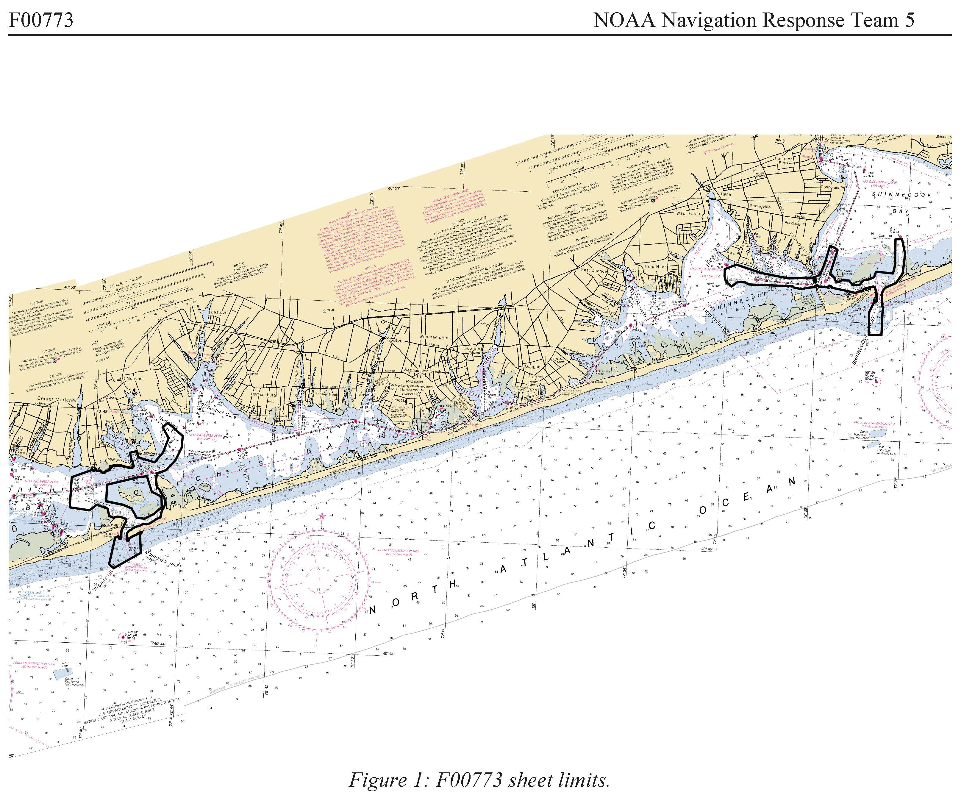
Federal
F00773: NOS Hydrographic Survey , 2019-06-07
National Oceanic and Atmospheric Administration, Department of Commerce —
The National Oceanic and Atmospheric Administration (NOAA) has the statutory mandate to collect hydrographic data in support of nautical chart compilation for safe... -
Federal
Long Island Sound 2016 NATURAL HAZARD
National Oceanic and Atmospheric Administration, Department of Commerce —
This feature class resides within the SOCECON Feature Data Set of the Long Island Sound 2016 ESI geodatabase. It contains vector polygons representing Natural Hazard... -
Federal
NOAA ESRI Shapefile - sediment composition class predictions in New York offshore planning area from Biogeography Branch
National Oceanic and Atmospheric Administration, Department of Commerce —
This dataset represents sediment composition class predictions from a sediment spatial model developed for the New York offshore spatial planning area. The predictive... -
Federal
Long Island Sound 2016 FISH
National Oceanic and Atmospheric Administration, Department of Commerce —
This feature class resides within the BIOLOGY Feature Data Set of the Long Island Sound - 2016 ESI Geodatabase. It contains vector polygons representing sensitive... -
Federal
Coastal Resources Atlas: Long Island: MGT (Management Area Polygons)
National Oceanic and Atmospheric Administration, Department of Commerce —
This data set contains human-use data for management areas, National Park Service properties, State Parks, and National Wildlife Refuges in Long Island, New York....

Official websites use .gov
A
.gov website belongs to an official government
organization in the United States.
Secure .gov websites use HTTPS
A
lock (
) or https:// means you’ve safely connected to
the .gov website. Share sensitive information only on official,
secure websites.