
-
Federal
Coastwide Reference Monitoring System (CRMS) 2021 Site 0605 land-water classification data
Department of the Interior —
Wetland restoration efforts conducted by the Coastal Wetlands Planning, Protection and Restoration Act (CWPPRA) in Louisiana rely on monitoring efforts to determine... -
Federal
Walton-Smith CTD, WS21032, WS21032_WS21032_Stn.56, 2021-02-03, 25.3495N 81.229W
National Oceanic and Atmospheric Administration, Department of Commerce —
Walton-Smith Conductivity, Temperature, Depth (CTD) - WS21032 - WS21032_WS21032_Stn.56 - 2021-02-03 - 25.3495N 81.229W. Hydrographic Measurements in the Gulf of... -
Federal
Coastwide Reference Monitoring System (CRMS) 2018 Site 2334 land-water classification data
Department of the Interior —
Wetland restoration efforts conducted by the Coastal Wetlands Planning, Protection and Restoration Act (CWPPRA) in Louisiana rely on monitoring efforts to determine... -
Federal
CRED Cumulative Map of Percent Scleractinian Coral Cover at Thirty Five Fathom Bank, Commonwealth of Northern Mariana Islands, USA
National Oceanic and Atmospheric Administration, Department of Commerce —
This map displays optical validation observation locations and percent coverage of scleractinian coral overlaid on bathymetry. -
Federal
Huron River near Hamburg, Michigan, flood-inundation model and field data
Department of the Interior —
Digital flood-inundation maps for an 8-mile (mi) reach of the Huron River from downstream of Rickett Road to Strawberry Lake, Michigan, were created by the U.S.... -
Federal
Walton-Smith CTD, WS17282, WS17282_WS17282_Stn54, 2017-10-12, 25.3432N 81.154W
National Oceanic and Atmospheric Administration, Department of Commerce —
Walton-Smith Conductivity, Temperature, Depth (CTD) - WS17282 - WS17282_WS17282_Stn54 - 2017-10-12 - 25.3432N 81.154W. Hydrographic Measurements in the Gulf of... -
Federal
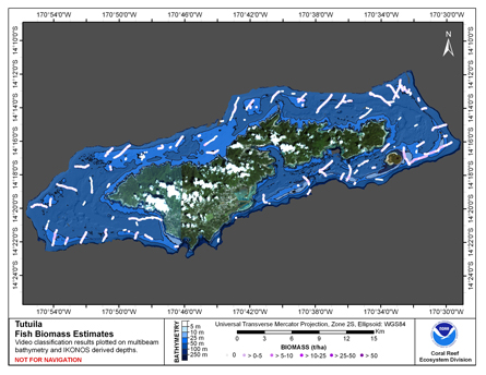
CRED Cumulative Fish Biomass map at Tutuila Island
National Oceanic and Atmospheric Administration, Department of Commerce —
This map displays fish biomass observation locations overlaid on bathymetry. -
Federal
Shoreline of Maui Derived From IKONOS and Quick Bird Satellite Imagery, 2004-2006
National Oceanic and Atmospheric Administration, Department of Commerce —
This project is a cooperative effort between the National Ocean Service, National Centers for Coastal Ocean Science, Center for Coastal Monitoring and Assessment, the... -
Federal
Coastwide Reference Monitoring System (CRMS) 2018 Site 0108 land-water classification data
Department of the Interior —
Wetland restoration efforts conducted by the Coastal Wetlands Planning, Protection and Restoration Act (CWPPRA) in Louisiana rely on monitoring efforts to determine... -
Federal
Walton-Smith CTD, WS1113, WS1113_Aug_2011_MR1, 2011-08-04, 24.143N 81.784W
National Oceanic and Atmospheric Administration, Department of Commerce —
Walton-Smith Conductivity, Temperature, Depth (CTD) - WS1113 - WS1113_Aug_2011_MR1 - 2011-08-04 - 24.143N 81.784W. Hydrographic Measurements in the Gulf of Mexico.... -
Federal
Walton-Smith CTD, WS21032, WS21032_WS21032_Stn.57, 2021-02-03, 25.351N 81.2587W
National Oceanic and Atmospheric Administration, Department of Commerce —
Walton-Smith Conductivity, Temperature, Depth (CTD) - WS21032 - WS21032_WS21032_Stn.57 - 2021-02-03 - 25.351N 81.2587W. Hydrographic Measurements in the Gulf of... -
Federal
Walton-Smith CTD, WS1207, WS1207_WS1207_0116, 2012-06-05, 24.673N 81.2027W
National Oceanic and Atmospheric Administration, Department of Commerce —
Walton-Smith Conductivity, Temperature, Depth (CTD) - WS1207 - WS1207_WS1207_0116 - 2012-06-05 - 24.673N 81.2027W. Hydrographic Measurements in the Gulf of Mexico.... -
Federal
Sebastian Pinnacles, Oculina Banks Clelia Dive 614 Narrative 2001 - Videotape and Visual Observations from Submersible Dives to the Oculina Banks Deep Sea Coral Reefs (NODC Accession 0047190)
National Oceanic and Atmospheric Administration, Department of Commerce —
These data are from one of fourteen 2001 submersible "Clelia" dives. Narratives including habitat descriptions and estimates of megafaunal species abundance were... -
Federal
Walton-Smith CTD, WS21032, WS21032_WS21032_Stn.TB4, 2021-02-05, 27.6225N 83.1343W
National Oceanic and Atmospheric Administration, Department of Commerce —
Walton-Smith Conductivity, Temperature, Depth (CTD) - WS21032 - WS21032_WS21032_Stn.TB4 - 2021-02-05 - 27.6225N 83.1343W. Hydrographic Measurements in the Gulf of... -
Federal
Coastwide Reference Monitoring System (CRMS) 2005, 2008, 2012, and 2016 Site 0157 land-water matrix
Department of the Interior —
Wetland restoration efforts conducted by the Coastal Wetlands Planning, Protection and Restoration Act (CWPPRA) in Louisiana rely on monitoring efforts to determine... -
Federal
Coastwide Reference Monitoring System (CRMS) 2021 Site BA0039-03 land-water classification data
Department of the Interior —
Wetland restoration efforts conducted by the Coastal Wetlands Planning, Protection and Restoration Act (CWPPRA) in Louisiana rely on monitoring efforts to determine... -
Federal
Savannah CTD, SAV18173, SAV18173_STA56, 2018-06-24, 25.351N 81.2283W
National Oceanic and Atmospheric Administration, Department of Commerce —
Savannah Conductivity, Temperature, Depth (CTD) - SAV18173 - SAV18173_STA56 - 2018-06-24 - 25.351N 81.2283W. Hydrographic Measurements in the Gulf of Mexico. flags: 1... -
Federal
Oceanographic data collected during the EX1503L1 (Tropical Exploration (Mapping I)) expedition on NOAA Ship OKEANOS EXPLORER in the North Atlantic Ocean from 2015-05-08 to 2015-05-13 (NCEI Accession 0129880)
National Oceanic and Atmospheric Administration, Department of Commerce —
Multibeam data was collected 24 hours a day and XBT casts were conducted at an interval defined by prevailing oceanographic conditions, not to exceed 6 hours.... -
Federal
Depth grids of flood inundation maps for Papillion Creek near Offutt Air Force Base, Nebraska
Department of the Interior —
These datasets are raster files that represent water depths associated with each flood inundation boundary for 157 flooding scenarios in an 8-mile reach of the... -
Federal
Walton-Smith CTD, WS1004, WS1004_WS1004_10, 2010-03-09, 24.7868N 80.8615W
National Oceanic and Atmospheric Administration, Department of Commerce —
Walton-Smith Conductivity, Temperature, Depth (CTD) - WS1004 - WS1004_WS1004_10 - 2010-03-09 - 24.7868N 80.8615W. Hydrographic Measurements in the Gulf of Mexico....

Official websites use .gov
A
.gov website belongs to an official government
organization in the United States.
Secure .gov websites use HTTPS
A
lock (
) or https:// means you’ve safely connected to
the .gov website. Share sensitive information only on official,
secure websites.