
-
Federal
TIGER/Line Shapefile, 2021, County, San Patricio County, TX, All Roads
U.S. Census Bureau, Department of Commerce —
The TIGER/Line shapefiles and related database files (.dbf) are an extract of selected geographic and cartographic information from the U.S. Census Bureau's Master... -
Federal
TIGER/Line Shapefile, 2021, County, Harrison County, TX, All Roads
U.S. Census Bureau, Department of Commerce —
The TIGER/Line shapefiles and related database files (.dbf) are an extract of selected geographic and cartographic information from the U.S. Census Bureau's Master... -
Federal
TIGER/Line Shapefile, 2021, County, Concho County, TX, All Roads
U.S. Census Bureau, Department of Commerce —
The TIGER/Line shapefiles and related database files (.dbf) are an extract of selected geographic and cartographic information from the U.S. Census Bureau's Master... -
Federal
H13184: NOS Hydrographic Survey , 2019-02-04
National Oceanic and Atmospheric Administration, Department of Commerce —
The National Oceanic and Atmospheric Administration (NOAA) has the statutory mandate to collect hydrographic data in support of nautical chart compilation for safe... -
Federal
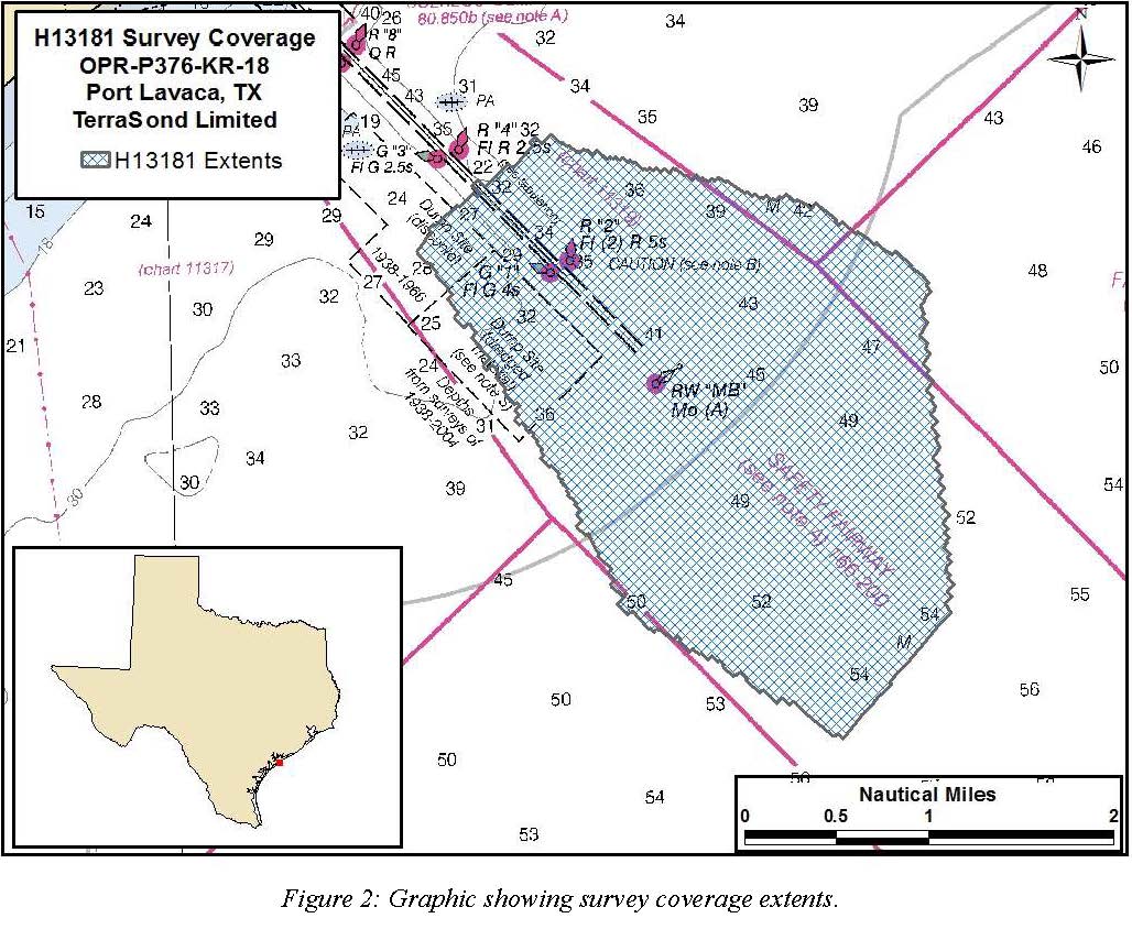
H13181: NOS Hydrographic Survey , 2018-12-12
National Oceanic and Atmospheric Administration, Department of Commerce —
The National Oceanic and Atmospheric Administration (NOAA) has the statutory mandate to collect hydrographic data in support of nautical chart compilation for safe... -
Federal
H13215: NOS Hydrographic Survey , 2019-09-28
National Oceanic and Atmospheric Administration, Department of Commerce —
The National Oceanic and Atmospheric Administration (NOAA) has the statutory mandate to collect hydrographic data in support of nautical chart compilation for safe... -
Federal
H13187: NOS Hydrographic Survey , 2018-12-13
National Oceanic and Atmospheric Administration, Department of Commerce —
The National Oceanic and Atmospheric Administration (NOAA) has the statutory mandate to collect hydrographic data in support of nautical chart compilation for safe... -
Federal
H12762: NOS Hydrographic Survey , 2015-08-11
National Oceanic and Atmospheric Administration, Department of Commerce —
The National Oceanic and Atmospheric Administration (NOAA) has the statutory mandate to collect hydrographic data in support of nautical chart compilation for safe... -
Federal
TIGER/Line Shapefile, 2021, County, San Augustine County, TX, All Roads
U.S. Census Bureau, Department of Commerce —
The TIGER/Line shapefiles and related database files (.dbf) are an extract of selected geographic and cartographic information from the U.S. Census Bureau's Master... -
Federal
Coastal Bend Texas Benthic Habitat Mapping Reprocessed DOQQ Aerial Imagery (NODC Accession 0086051)
National Oceanic and Atmospheric Administration, Department of Commerce —
In 2006 and 2007 the NOAA Coastal Services Center purchased services to reprocess existing digital multi-spectral imagery (ADS-40) and create digital benthic habitat... -
Federal
TIGER/Line Shapefile, 2021, County, Live Oak County, TX, All Roads
U.S. Census Bureau, Department of Commerce —
The TIGER/Line shapefiles and related database files (.dbf) are an extract of selected geographic and cartographic information from the U.S. Census Bureau's Master... -
Federal
Coastal Bend Texas Benthic Habitat Mapping Baffin Bay (NODC Accession 0070784)
National Oceanic and Atmospheric Administration, Department of Commerce —
In 2006 and 2007 the NOAA Coastal Services Center purchased services to process existing digital multi-spectral imagery (ADS-40) and create digital benthic habitat... -
Federal
TIGER/Line Shapefile, 2021, County, Schleicher County, TX, All Roads
U.S. Census Bureau, Department of Commerce —
The TIGER/Line shapefiles and related database files (.dbf) are an extract of selected geographic and cartographic information from the U.S. Census Bureau's Master... -
Federal
Coastal Bend Texas Benthic Habitat Mapping Aransas Bay 2004 Substrate
National Oceanic and Atmospheric Administration, Department of Commerce —
In 2006 and 2007 the NOAA Office for Coastal Management purchased services to process existing digital multi-spectral imagery (ADS-40) and create digital benthic... -
Federal
TIGER/Line Shapefile, 2024, State, Texas, TX, State Legislative District (SLD) Upper Chamber
U.S. Census Bureau, Department of Commerce —
The TIGER/Line shapefiles and related database files (.dbf) are an extract of selected geographic and cartographic information from the U.S. Census Bureau's Master... -
Federal
TIGER/Line Shapefile, 2021, County, Lamb County, TX, All Roads
U.S. Census Bureau, Department of Commerce —
The TIGER/Line shapefiles and related database files (.dbf) are an extract of selected geographic and cartographic information from the U.S. Census Bureau's Master... -
Federal
TIGER/Line Shapefile, 2021, State, Texas, Elementary School Districts
U.S. Census Bureau, Department of Commerce —
The TIGER/Line shapefiles and related database files (.dbf) are an extract of selected geographic and cartographic information from the U.S. Census Bureau's Master... -
Federal
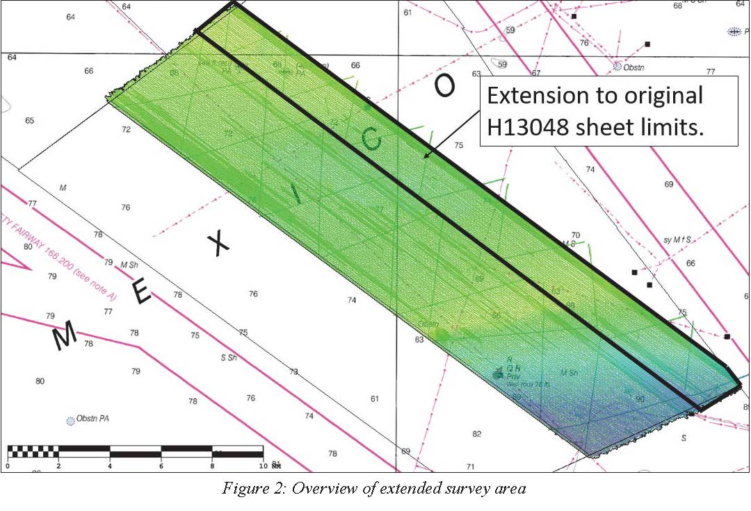
H13048: NOS Hydrographic Survey , 2018-08-07
National Oceanic and Atmospheric Administration, Department of Commerce —
The National Oceanic and Atmospheric Administration (NOAA) has the statutory mandate to collect hydrographic data in support of nautical chart compilation for safe... -
Federal
2023 Cartographic Boundary File (KML), State Legislative District (SLD) Lower Chamber for Texas, 1:500,000
U.S. Census Bureau, Department of Commerce —
The 2023 cartographic boundary KMLs are simplified representations of selected geographic areas from the U.S. Census Bureau's Master Address File / Topologically... -
Federal
TIGER/Line Shapefile, 2021, County, Hockley County, TX, All Roads
U.S. Census Bureau, Department of Commerce —
The TIGER/Line shapefiles and related database files (.dbf) are an extract of selected geographic and cartographic information from the U.S. Census Bureau's Master...

Official websites use .gov
A
.gov website belongs to an official government
organization in the United States.
Secure .gov websites use HTTPS
A
lock (
) or https:// means you’ve safely connected to
the .gov website. Share sensitive information only on official,
secure websites.