-
Federal
2023 Cartographic Boundary File (SHP), Secondary School District for California, 1:500,000
U.S. Census Bureau, Department of Commerce —
The 2023 cartographic boundary shapefiles are simplified representations of selected geographic areas from the U.S. Census Bureau's Master Address File /... -
Federal
2024 Cartographic Boundary File (SHP), Unified School District for California, 1:500,000
U.S. Census Bureau, Department of Commerce —
The 2024 cartographic boundary shapefiles are simplified representations of selected geographic areas from the U.S. Census Bureau's Master Address File /... -
Federal
Airborne geophysical survey: Salton Sea North '81, California Survey Part 2 of 2
Department of the Interior —
Aeromagnetic data were collected along flight lines by instruments in an aircraft that recorded magnetic-field values and locations. This dataset presents latitude,... -
Federal
2024 Cartographic Boundary File (SHP), Secondary School District for California, 1:500,000
U.S. Census Bureau, Department of Commerce —
The 2024 cartographic boundary shapefiles are simplified representations of selected geographic areas from the U.S. Census Bureau's Master Address File /... -
Federal
l383wf.m77t - MGD77 data file for Geophysical data from field activity L-3-83-WF in Juan de Fuca from 08/19/1983 to 09/01/1983
Department of the Interior —
Single-beam bathymetry and gravity data along with DGPS navigation data was collected as part of field activity L-3-83-WF in Juan de Fuca from 08/19/1983 to... -
Federal
Lassen Volcanic National Park Small-Scale Base GIS Data
Department of the Interior —
This data set contains small-scale base GIS data layers compiled by the National Park Service Servicewide Inventory and Monitoring Program and Water Resources... -
Federal
EnviroAtlas - Fresno, CA - Block Groups
U.S. Environmental Protection Agency —
This EnviroAtlas dataset is the base layer for the Fresno, CA EnviroAtlas area. The block groups are from the US Census Bureau and are included/excluded based on... -
Federal
EnviroAtlas - San Diego, CA - Estimated Percent Tree Cover Along Walkable Roads
U.S. Environmental Protection Agency —
This EnviroAtlas dataset estimates tree cover along walkable roads. The road width is estimated for each road and percent tree cover is calculated in a 8.5 meter... -
Federal
EnviroAtlas - Sonoma County, CA - Residents with Minimal Potential Window Views of Trees by Block Group
U.S. Environmental Protection Agency —
This EnviroAtlas dataset shows the total block group population and the percentage of the block group population that has little access to potential window views of... -
Federal
EnviroAtlas - Los Angeles, CA - Demographics by Block Group
U.S. Environmental Protection Agency —
This EnviroAtlas dataset is a summary of key demographic groups for the EnviroAtlas community. This dataset was produced by the US EPA to support research and online... -
Federal
1:6000 Scale (6K) Quadrangles developed by USEPA to Support Reconnaissance, and Tactical and Strategic Planning for Emergency Responses and Homeland Security Events (Region 9 Extract)
U.S. Environmental Protection Agency —
Reference quads for emergency response reconnaissance developed for use by the US Environmental Protection Agency. Grid cells are based on densification of the USGS... -
Federal
EnviroAtlas - Fresno, CA - Land Cover by Block Group
U.S. Environmental Protection Agency —
This EnviroAtlas dataset describes the breakdown of the land cover classes with each Census Block Group. In this community, forest is defined as Trees & Forest... -
Federal
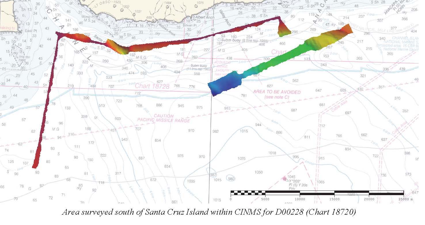
D00228: NOS Hydrographic Survey
National Oceanic and Atmospheric Administration, Department of Commerce —
The National Oceanic and Atmospheric Administration (NOAA) has the statutory mandate to collect hydrographic data in support of nautical chart compilation for safe... -
Federal
Carrying Out Climate Scenario Planning for the Kenai Peninsula, Alaska - NERRS/NSC(NERRS Science Collaborative)
National Oceanic and Atmospheric Administration, Department of Commerce —
Drawing upon experience using scenario planning to help local communities prepare for climate change in the Tijuana River Valley (Southern California), the project... -
Federal
TIGER/Line Shapefile, 2021, State, California, 2020 Census Blocks
U.S. Census Bureau, Department of Commerce —
The TIGER/Line shapefiles and related database files (.dbf) are an extract of selected geographic and cartographic information from the U.S. Census Bureau's Master... -
Federal
SECRUHAB -- Habitat polygons for Southeast Santa Cruz Island (UTM 10N, NAD83)
Department of the Interior —
Benthic habitat polygon coverages have been created for marine reserve locations surrounding the Santa Barbara Basin. Diver, ROV and submersible video transects,... -
Federal
EnviroAtlas - Los Angeles, CA - Ecosystem Services by Block Group
U.S. Environmental Protection Agency —
This EnviroAtlas dataset presents environmental benefits of the urban forest in 6421 block groups in Los Angeles County, California. Carbon attributes, temperature... -
Federal
SMIG1M.TIF - Sidescan sonar image of South San Miguel Island (UTM 10N, NAD83)
Department of the Interior —
The sidescan sonar image of the nearshore seafloor (0 to 100 m water depths) of the Big Sycamore reserve area was mosaicked from data collected in 1998. A Klein 2000... -
Federal
SCAV2OBS -- Assorted visual observations of benthic habitat from ROV and SCUBA dives in the Channel Islands National Marine Sanctuary. (UTM 10N, NAD83)
Department of the Interior —
Point based visual observations of benthic habitat from a variety of SCUBA and ROV dives. Unknown postitional accuracy. Some video data maintained by Russ Vetter,... -
Federal
Remote Sensing Shrub/Grass National Land Cover Database (NLCD) Back-in-Time (BIT) Shrub Products for the Western U.S., 1985 - 2018
Department of the Interior —
The need to monitor change in sagebrush steppe is urgent due to the increasing impacts of climate change, shifting fire regimes, and management practices on ecosystem...

Official websites use .gov
A
.gov website belongs to an official government
organization in the United States.
Secure .gov websites use HTTPS
A
lock (
) or https:// means you’ve safely connected to
the .gov website. Share sensitive information only on official,
secure websites.