
-
Federal
Shorelines of the central North Carolina (NCcentral) coastal region used in shoreline change analysis
Department of the Interior —
Sandy ocean beaches are a popular recreational destination, often surrounded by communities containing valuable real estate. Development is on the rise despite the... -
Federal
TIGER/Line Shapefile, 2022, State, North Carolina, 118th Congressional District
U.S. Census Bureau, Department of Commerce —
The TIGER/Line shapefiles and related database files (.dbf) are an extract of selected geographic and cartographic information from the U.S. Census Bureau's Master... -
Federal
TIGER/Line Shapefile, 2021, County, Surry County, NC, All Roads
U.S. Census Bureau, Department of Commerce —
The TIGER/Line shapefiles and related database files (.dbf) are an extract of selected geographic and cartographic information from the U.S. Census Bureau's Master... -
Federal
H13596: NOS Hydrographic Survey , 2022-08-13
National Oceanic and Atmospheric Administration, Department of Commerce —
The National Oceanic and Atmospheric Administration (NOAA) has the statutory mandate to collect hydrographic data in support of nautical chart compilation for safe... -
Federal
W00335: NOS Hydrographic Survey , 2014-07-20
National Oceanic and Atmospheric Administration, Department of Commerce —
The National Oceanic and Atmospheric Administration (NOAA) has the statutory mandate to collect hydrographic data in support of nautical chart compilation for safe... -
Federal
TIGER/Line Shapefile, 2020, State, North Carolina, State Legislative District (SLD) Lower Chamber
U.S. Census Bureau, Department of Commerce —
The TIGER/Line shapefiles and related database files (.dbf) are an extract of selected geographic and cartographic information from the U.S. Census Bureau's Master... -
Federal
Uncertainty table for lidar-derived shorelines used when calculating rates in the Digital Shoreline Analysis System software for northern North Carolina (NCnorth)
Department of the Interior —
Sandy ocean beaches are a popular recreational destination, often surrounded by communities containing valuable real estate. Development is on the rise despite the... -
Federal
2020 Cartographic Boundary File (KML), Current Place for North Carolina, 1:500,000
U.S. Census Bureau, Department of Commerce —
The 2020 cartographic boundary KMLs are simplified representations of selected geographic areas from the U.S. Census Bureau's Master Address File / Topologically... -
Federal
Digital Shoreline Analysis System version 4.3 Transects with Short-Term Linear Regression Rate Calculations for northern North Carolina (NCnorth)
Department of the Interior —
Sandy ocean beaches are a popular recreational destination, often surrounded by communities containing valuable real estate. Development is on the rise despite the... -
Federal
Chirp trackline navigation data from USGS cruise 2003-042-FA from Pamlico Sound, North Carolina (bbc2003042_tracklines.shp)
Department of the Interior —
The northeastern North Carolina coastal system, from False Cape, Virginia, to Cape Lookout, North Carolina, has been studied by a cooperative research program that... -
Federal
Offshore baseline for the southern North Carolina (NCsouth) coastal region generated to calculate shoreline change rates
Department of the Interior —
Sandy ocean beaches are a popular recreational destination, often surrounded by communities containing valuable real estate. Development is on the rise despite the... -
Federal
Cape Hatteras National Seashore Small-Scale Base GIS Data
Department of the Interior —
This data set contains small-scale base GIS data layers compiled by the National Park Service Servicewide Inventory and Monitoring Program and Water Resources... -
Federal
Chirp shotpoint navigation from USGS cruise 2002-015-FA from Pamlico Sound, North Carolina (bbc2002015_shots.shp)
Department of the Interior —
The northeastern North Carolina coastal system, from False Cape, Virginia, to Cape Lookout, North Carolina, has been studied by a cooperative research program that... -
Federal
30-m Average Curvature
Department of the Interior —
The lidar Average Curvature is the Average Curvature data product produced and distributed by the National Park Service, Great Smoky Mountains National Park. The... -
Federal
Offshore baseline for the western North Carolina (NCwest) coastal region generated to calculate shoreline change rates
Department of the Interior —
Sandy ocean beaches are a popular recreational destination, often surrounded by communities containing valuable real estate. Development is on the rise despite the... -
Federal
30-m Plan Curvature
Department of the Interior —
The lidar Plan Curvature is the Plan Curvature data product produced and distributed by the National Park Service, Great Smoky Mountains National Park. The primary... -
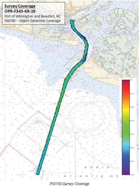
Federal
F00790: NOS Hydrographic Survey , 2019-09-08
National Oceanic and Atmospheric Administration, Department of Commerce —
The National Oceanic and Atmospheric Administration (NOAA) has the statutory mandate to collect hydrographic data in support of nautical chart compilation for safe... -
Federal
Moores Creek National Battlefield Small-Scale Base GIS Data
Department of the Interior —
This data set contains small-scale base GIS data layers compiled by the National Park Service Servicewide Inventory and Monitoring Program and Water Resources... -
Federal
Digital Shoreline Analysis System version 4.3 Transects with Short-Term End Point Rate Calculations for southern North Carolina (NCsouth)
Department of the Interior —
Sandy ocean beaches are a popular recreational destination, often surrounded by communities containing valuable real estate. Development is on the rise despite the... -
Federal
Digital Shoreline Analysis System version 4.3 Transects with Short-Term Linear Regression Rate Calculations for western North Carolina (NCwest)
Department of the Interior —
Sandy ocean beaches are a popular recreational destination, often surrounded by communities containing valuable real estate. Development is on the rise despite the...

Official websites use .gov
A
.gov website belongs to an official government
organization in the United States.
Secure .gov websites use HTTPS
A
lock (
) or https:// means you’ve safely connected to
the .gov website. Share sensitive information only on official,
secure websites.