
-
Federal
NOAA GOES-R Series Advanced Baseline Imager (ABI) Level 2 Sea Surface Temperature (SST) (Skin)
National Oceanic and Atmospheric Administration, Department of Commerce —
The GOES-R Advanced Baseline Imager (ABI) Sea Surface (Skin) Temperature product contains an image with pixel values identifying the variations in temperature of the... -
Federal
FIREX-AQ NOAA-CHEM Twin Otter Photolysis Rate (j value) Data
National Aeronautics and Space Administration —
FIREXAQ_jValue_AircraftInSitu_N48_Data are in situ photolysis rate (j value) data collected onboard the NOAA-CHEM Twin Otter aircraft during FIREX-AQ. Data collection... -
Federal
F00444: NOS Hydrographic Survey , Charleston Harbor, South Carolina and Adjoining Waterways, South Carolina, 1998-09-01
National Oceanic and Atmospheric Administration, Department of Commerce —
The National Oceanic and Atmospheric Administration (NOAA) has the statutory mandate to collect hydrographic data in support of nautical chart compilation for safe... -
Federal
GLDAS Noah Land Surface Model L4 3 hourly 0.25 x 0.25 degree V2.0 (GLDAS_NOAH025_3H) at GES DISC
National Aeronautics and Space Administration —
NASA Global Land Data Assimilation System Version 2 (GLDAS-2) has three components: GLDAS-2.0, GLDAS-2.1, and GLDAS-2.2. GLDAS-2.0 is forced entirely with the... -
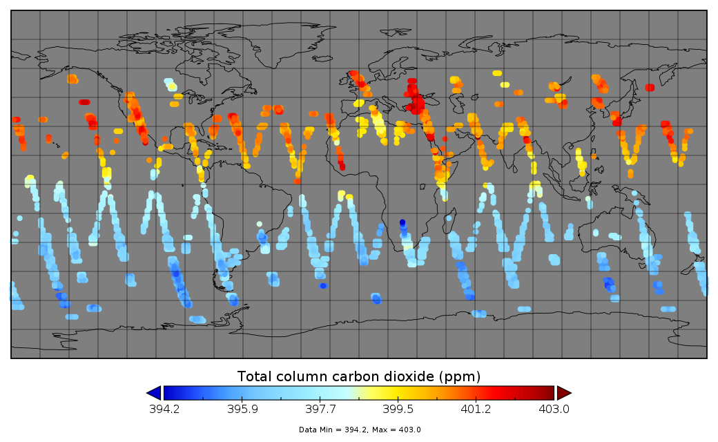
Federal
Multi-Instrument Fused bias-corrected XCO2 and other select fields aggregated as Level 4 daily files V3 (MultiInstrumentFusedXCO2)
National Aeronautics and Space Administration —
Gridded carbon dioxide mole fraction (XCO2) and other select variables created by applying local kriging (also known as optimal interpolation) to daily aggregates of... -
Federal
OPERA Land Surface Disturbance Alert from Harmonized Landsat Sentinel-2 product (Version 1)
National Aeronautics and Space Administration —
The Observational Products for End-Users from Remote Sensing Analysis (OPERA) Land Surface Disturbance Alert from... -
Federal
Coastal Mapping Program of Dog River, AL, AL2401A-CM-N NGDA
National Oceanic and Atmospheric Administration, Department of Commerce —
These data provide an accurate high-resolution shoreline compiled from imagery of Dog River, AL . This vector shoreline data is based on an office interpretation of... -
Federal
Data Files for “The 2030 National Charging Network: Estimating U.S. Light-Duty Demand for Electric Vehicle Charging Infrastructure"
Department of Energy —
This data set includes modeling results from “The 2030 National Charging Network: Estimating U.S. Light-Duty Demand for Electric Vehicle Charging Infrastructure”... -
Federal
Trajectory profile data from glider ru30, including pH, total alkalinity, and aragonite saturation state, deployed by Rutgers, the State University of New Jersey in the Mid-Atlantic Bight from 2021-07-16 to 2021-08-20 (NCEI Accession 0281781)
National Oceanic and Atmospheric Administration, Department of Commerce —
This dataset contains the trajectory profile data from glider ru30 from one seasonal deployment (2021-07-16 to 2021-08-20) to investigate carbonate chemistry and... -
Federal
NOAA Marine Debris Clearinghouse Program data on debris surveys and removal projects from 2005 to 2019 (NCEI Accession 0190414)
National Oceanic and Atmospheric Administration, Department of Commerce —
This data set contains information on historical marine debris survey and removal projects of the NOAA Marine Debris Program and its many funded partners. This data... -
Federal
PFAS measured in multiple indoor media. September 2024
U.S. Environmental Protection Agency —
Summary statistics for PFAS measured in tap water, glass slab wipes, and house dust. Associated method and QC information. This dataset is associated with the... -
Federal
Sentinel-1C Single Polarization Full Resolution Ground Range Detected Product Metadata
National Aeronautics and Space Administration —
The Sentinel-1C satellite was launched December 5, 2024. Sentinel-1C is the the latest satellite to be added to the Sentinel-1 constellation. The Sentinel-1... -
Federal
ECCO Ocean Three-Dimensional Volume Fluxes - Monthly Mean llc90 Grid (Version 4 Release 4)
National Aeronautics and Space Administration —
This dataset provides monthly-averaged ocean three-dimensional volume fluxes on the native Lat-Lon-Cap 90 (LLC90) model grid from the ECCO Version 4 Release 4 (V4r4)... -
Federal
BARREL 1G X-ray Spectrometer (FSPC) Bremsstrahlung X-ray Spectrum Fast Time Resolution, Level 2, 0.05 s Data
National Aeronautics and Space Administration —
FSPC: Four channels of fast time resolution, 50 ms, Bremsstrahlung X-ray spectra detected with a NaI Scintillator. Each channel is separated in its own variable:... -
Federal
AIS Vessel Tracks 2016
National Oceanic and Atmospheric Administration, Department of Commerce —
Vessels traveling in U.S. coastal and inland waters frequently use Automatic Identification Systems (AIS) for navigation safety. The U.S. Coast Guard collects AIS... -
Federal
Water level monitoring data at Lake Carl Blackwell, Payne County, Oklahoma
Department of Agriculture —
A radar water level sensor (Campbell Scientific ® CS475A-L) was installed on the water intake tower of Lake Carl Blackwell, Payne County, Oklahoma (36.1351 N, 97.2195... -
Federal
2014 Metro, Oregon 4-Band 8 Bit Imagery
National Oceanic and Atmospheric Administration, Department of Commerce —
These data are LiDAR orthorectified aerial photographs (8-bit GeoTIFF format) within the Oregon Lidar Consortium Portland project area. The imagery coverage is...

Official websites use .gov
A
.gov website belongs to an official government
organization in the United States.
Secure .gov websites use HTTPS
A
lock (
) or https:// means you’ve safely connected to
the .gov website. Share sensitive information only on official,
secure websites.
.jpg)