
-
Federal
Bathymetric Survey of the Nearshore from Belle Pass to Caminada Pass, Louisiana: Methods and Data Report
Department of the Interior —
The U.S. Geological Survey (USGS), in cooperation with the University of New Orleans (UNO) and the Louisiana Department of Natural Resources (LDNR), conducted a high-... -
Federal
Abundance and behavior of parrotfishes (Labridae, Scarinae) in the upper Florida Keys from 2013-06-19 to 2013-07-30 (NCEI Accession 0127525)
National Oceanic and Atmospheric Administration, Department of Commerce —
To better understand the functional roles of parrotfishes on Caribbean coral reefs we documented abundance, habitat preferences, and diets of nine species of... -
Federal
NOAA/NCEI 90-m Bathymetry: American Samoa
National Oceanic and Atmospheric Administration, Department of Commerce —
A 90-m (3 arc-second) resolution gridded digital elevation model (DEM) for the bathymetry (ocean depth) surrounding American Samoa, including the islands of Tutuila,... -
Federal
Currents, HF Radar, Puerto Rico and the US Virgin Islands, RTV, Near-Real Time, 2012-present, Hourly, 2km, Lon0360
National Oceanic and Atmospheric Administration, Department of Commerce —
Surface ocean velocities estimated from HF-Radar are representative of the upper 1.0 meters of the ocean. The main objective of near-real time processing is to... -
Federal
H04351: NOS Hydrographic Survey
National Oceanic and Atmospheric Administration, Department of Commerce —
The National Oceanic and Atmospheric Administration (NOAA) has the statutory mandate to collect hydrographic data in support of nautical chart compilation for safe... -
Federal
October 1994 Shikotan, Kuril Islands, Russia Images
National Oceanic and Atmospheric Administration, Department of Commerce —
A magnitude 8.1 earthquake occurred in the southern Kurils and on northern Hokkaido on Tuesday, October 5, 1994, (October 4 at 13:23 GMT). It was a sudden event,... -
Federal
Northern Gulf 1 arc-second NAVD 88 Coastal Digital Elevation Model
National Oceanic and Atmospheric Administration, Department of Commerce —
NOAA's National Geophysical Data Center (NGDC) is building high-resolution digital elevation models (DEMs) for select U.S. coastal regions in the Gulf of Mexico.... -
Federal
H11078: NOS Hydrographic Survey , Pollock Rip Channel, Massachusetts, 2001-09-13
National Oceanic and Atmospheric Administration, Department of Commerce —
The National Oceanic and Atmospheric Administration (NOAA) has the statutory mandate to collect hydrographic data in support of nautical chart compilation for safe... -
Federal
SanctSound Sound Propagation Models
National Oceanic and Atmospheric Administration, Department of Commerce —
The map shows the signal-to-noise ratio (SNR) calculated as the difference between predicted received level (RL) at the hydrophone and the wind-induced noise level... -
Federal
Seawater Temperature and Salinity Moored Time-Series Records, Collected During 2010 and 2011 in Vieques Sound and Virgin Passage (NODC Accession 0088063)
National Oceanic and Atmospheric Administration, Department of Commerce —
Sea-Bird SBE37SM MicroCat Conductivity/Temperature (CT) recorders were deployed between March 2010 and April 2011 on shallow water moorings located in Vieques Sound,... -
Federal
Salish Sea water level validation simulations: 2017-2020
Department of the Interior —
Simulations of water levels in the Salish Sea over the period October 1, 2016 to September 30, 2020 were conducted to validate the Salish Sea hydrodynamic model. The... -
Federal
Puget Sound 1/3 arc-second NAVD 88 Coastal Digital Elevation Model
National Oceanic and Atmospheric Administration, Department of Commerce —
NOAA's National Geophysical Data Center (NGDC) is building high-resolution digital elevation models (DEMs) for select U.S. coastal regions. These integrated... -
Federal
Mountains in the Sea - Exploring the New England Seamount Chain on RV Atlantis in North Atlantic Ocean between 20030711 and 20030719
National Oceanic and Atmospheric Administration, Department of Commerce —
This summer, an interdisciplinary scientific team spent 9 days aboard the Woods Hole Oceanographic Institution's research vessel Atlantis II and used the deep-sea... -
Federal
CMECS geoform, substrate, and biotopes offshore of Tacoma, Washington
Department of the Interior —
This part of USGS Data Series 935 (Cochrane, 2014) presents substrate, geomorphic, and biotope data in the Offshore of Tacoma, Washington, map area, a part of the... -
Federal
H12551: NOS Hydrographic Survey , Approaches to Barataria Bay, LA, 2014-01-20
National Oceanic and Atmospheric Administration, Department of Commerce —
The National Oceanic and Atmospheric Administration (NOAA) has the statutory mandate to collect hydrographic data in support of nautical chart compilation for safe... -
Federal
Time series for the central Beaufort Sea coast, Alaska
Department of the Interior —
Time series output from a spectral wave model (Simulating Waves WAves Nearshore [SWAN]; Booij and others 1999), implemented for the central Beaufort Sea coast of... -
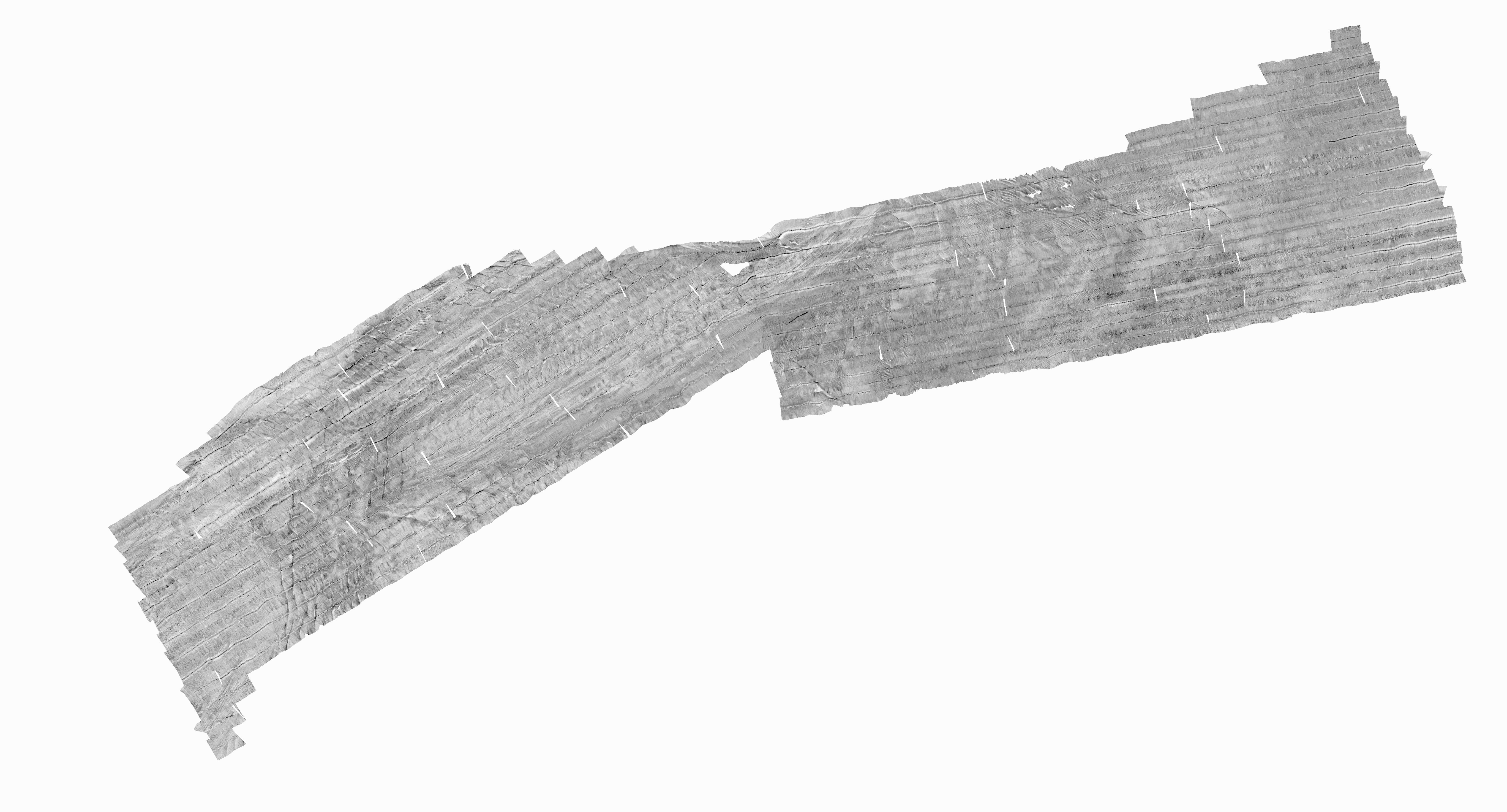
Federal
JI_Q07.TIF - Johnston Island U.S. EEZ GLORIA sidescan-sonar data mosaic (7 of 16) (LCC, 50 m, WGS84)
Department of the Interior —
In 1984, the U.S. Geological Survey (USGS), Office of Marine Geology, launched a program using the Geological LOng-Range Inclined Asdic (GLORIA) sidescan-sonar system... -
Federal
Moderate Resolution Imaging Spectroradiometer (MODIS) - Aqua NGDA
National Aeronautics and Space Administration —
This dataset represents multiple products archived at the multiple archive centers for the MODIS (Moderate Resolution Imaging Spectroradiometer) instrument aboard the... -
Federal
Multi-scale Ultra-high Resolution (MUR) SST Analysis fv04.1, Global, 0.01°, 2002-present, Daily, Lon0360
National Oceanic and Atmospheric Administration, Department of Commerce —
This is a merged, multi-sensor L4 Foundation Sea Surface Temperature (SST) analysis product from Jet Propulsion Laboratory (JPL). This daily, global, Multi-scale,... -
Federal
Hydrographic and Impairment Statistics Database: NPS-WSR Tlikakila Wild and Scenic River
Department of the Interior —
Hydrographic and Impairment Statistics (HIS) is a National Park Service (NPS) Water Resources Division (WRD) project established to track certain goals created in...

Official websites use .gov
A
.gov website belongs to an official government
organization in the United States.
Secure .gov websites use HTTPS
A
lock (
) or https:// means you’ve safely connected to
the .gov website. Share sensitive information only on official,
secure websites.