
-
Federal
TIGER/Line Shapefile, 2020, State, North Carolina, NC, 118th Congressional District
U.S. Census Bureau, Department of Commerce —
The TIGER/Line shapefiles and related database files (.dbf) are an extract of selected geographic and cartographic information from the U.S. Census Bureau's Master... -
Federal
Location of rotasonic cores from northeastern North Carolina Volumes I to IV: Cores OBX-01 through OBX-18 and MLD-01 through MLD-10 (obx_cores.shp, geographic, WGS 84)
Department of the Interior —
The northeastern North Carolina coastal system, from False Cape, Virginia, to Cape Lookout, North Carolina, has been studied by a cooperative research program that... -
Federal
EnviroAtlas - Durham, NC - Residents with Potential Window Views of Trees by Block Group
U.S. Environmental Protection Agency —
This EnviroAtlas dataset shows the total block group population and the percentage of the block group population that has little access to potential window views of... -
Federal
EnviroAtlas - Durham, NC - Greenspace Proximity Gradient
U.S. Environmental Protection Agency —
In any given 1-square meter point in this EnviroAtlas dataset, the value shown gives the percentage of square meters of greenspace within 1/4 square kilometer... -
Federal
Submerged Aquatic Vegetation of Bogue Sound, North Carolina 1992 Biotic
National Oceanic and Atmospheric Administration, Department of Commerce —
During 1992, 1:20,000 scale aerial photography for Bogue Sound, North Carolina was collected as part of an effort to map submerged aquatic vegetation (SAV) in Coastal... -
Federal
1:6000 Scale (6K) Quadrangles developed by USEPA to Support Reconnaissance, and Tactical and Strategic Planning for Emergency Responses and Homeland Security Events (Region 4 Extract)
U.S. Environmental Protection Agency —
Reference quads for emergency response reconnaissance developed for use by the US Environmental Protection Agency. Grid cells are based on densification of the USGS... -
Federal
Storm Stories: Communicating Hurricane Impacts using Monitoring Data and Visualizations - NERRS/NSC(NERRS Science Collaborative)
National Oceanic and Atmospheric Administration, Department of Commerce —
By pairing water quality and meteorological data with visible impacts, reserves can illustrate storm impacts and connect local communities to science. The project... -
Federal
TIGER/Line Shapefile, 2021, County, Union County, NC, All Roads
U.S. Census Bureau, Department of Commerce —
The TIGER/Line shapefiles and related database files (.dbf) are an extract of selected geographic and cartographic information from the U.S. Census Bureau's Master... -
Federal
TIGER/Line Shapefile, 2021, County, Alamance County, NC, All Roads
U.S. Census Bureau, Department of Commerce —
The TIGER/Line shapefiles and related database files (.dbf) are an extract of selected geographic and cartographic information from the U.S. Census Bureau's Master... -
Federal
W00332: NOS Hydrographic Survey , 2014-07-20
National Oceanic and Atmospheric Administration, Department of Commerce —
The National Oceanic and Atmospheric Administration (NOAA) has the statutory mandate to collect hydrographic data in support of nautical chart compilation for safe... -
Federal
TIGER/Line Shapefile, 2021, County, Yancey County, NC, All Roads
U.S. Census Bureau, Department of Commerce —
The TIGER/Line shapefiles and related database files (.dbf) are an extract of selected geographic and cartographic information from the U.S. Census Bureau's Master... -
Federal
TIGER/Line Shapefile, 2021, County, Ashe County, NC, All Roads
U.S. Census Bureau, Department of Commerce —
The TIGER/Line shapefiles and related database files (.dbf) are an extract of selected geographic and cartographic information from the U.S. Census Bureau's Master... -
Federal
TIGER/Line Shapefile, 2021, County, Iredell County, NC, All Roads
U.S. Census Bureau, Department of Commerce —
The TIGER/Line shapefiles and related database files (.dbf) are an extract of selected geographic and cartographic information from the U.S. Census Bureau's Master... -
Federal
2023 Cartographic Boundary File (KML), State Legislative District (SLD) Upper Chamber for North Carolina, 1:500,000
U.S. Census Bureau, Department of Commerce —
The 2023 cartographic boundary KMLs are simplified representations of selected geographic areas from the U.S. Census Bureau's Master Address File / Topologically... -
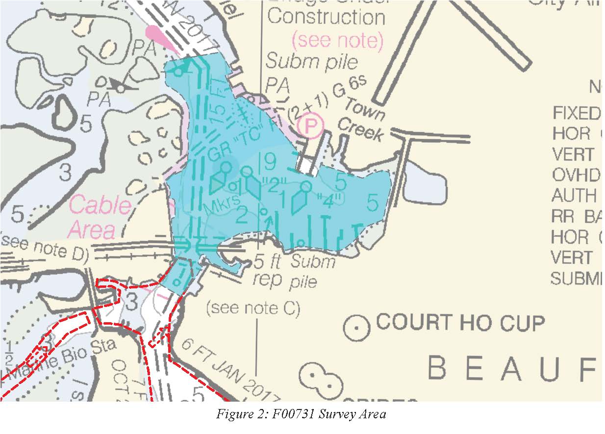
Federal
F00731: NOS Hydrographic Survey , 2018-07-11
National Oceanic and Atmospheric Administration, Department of Commerce —
The National Oceanic and Atmospheric Administration (NOAA) has the statutory mandate to collect hydrographic data in support of nautical chart compilation for safe... -
Federal
Location of MMS (Minerals Management Service) vibracores from offshore northern Dare County, North Carolina (mms_cores.shp, geographic, WGS 84)
Department of the Interior —
The northeastern North Carolina coastal system, from False Cape, Virginia, to Cape Lookout, North Carolina, has been studied by a cooperative research program that... -
Federal
Airborne geophysical survey: Near Charlotte, North Carolina
Department of the Interior —
Aeromagnetic data were collected along flight lines by instruments in an aircraft that recorded magnetic-field values and locations. This dataset presents latitude,... -
Federal
shoreline, inletLines: Shoreline polygons and tidal inlet delineations: Cape Lookout, NC, 2014
Department of the Interior —
Understanding how sea-level rise will affect coastal landforms and the species and habitats they support is critical for crafting approaches that balance the needs of... -
Federal
H13594: NOS Hydrographic Survey , 2022-03-25
National Oceanic and Atmospheric Administration, Department of Commerce —
The National Oceanic and Atmospheric Administration (NOAA) has the statutory mandate to collect hydrographic data in support of nautical chart compilation for safe...

Official websites use .gov
A
.gov website belongs to an official government
organization in the United States.
Secure .gov websites use HTTPS
A
lock (
) or https:// means you’ve safely connected to
the .gov website. Share sensitive information only on official,
secure websites.