
-
Federal
NASA 3D Models: ICESat
National Aeronautics and Space Administration —
ICESat (Ice, Cloud, and land Elevation Satellite) is the benchmark Earth Observing System mission for measuring ice sheet mass balance, cloud and aerosol heights, as... -
Federal
Decadal Land Use and Land Cover Classifications across India, 1985, 1995, 2005
National Aeronautics and Space Administration —
This data set provides land use and land cover (LULC) classification products at 100-m resolution for India at decadal intervals for 1985, 1995 and 2005. The data... -
Federal
Lynga Open Clusters Catalog
National Aeronautics and Space Administration —
This is a catalog of open cluster data, as compiled by Gosta Lynga, Lund Observatory. The aim of this catalog is to give salient data for all known open star clusters... -
Federal
COSMOS2020 Farmer Catalog
National Aeronautics and Space Administration —
In these catalogues, source detection and multi-wavelength photometry is performed for 1.7 million sources in the 2 square degree COSMOS field. Approximately 966,000... -
Federal
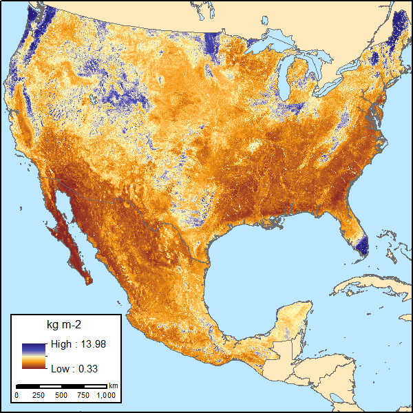
Soil Organic Carbon Estimates for 30-cm Depth, Mexico and Conterminous USA, 1991-2011
National Aeronautics and Space Administration —
This dataset provides two sets of gridded estimates of estimated soil organic carbon (SOC) and associated uncertainties for 0-30 cm topsoil layer in kg SOC/m2 at... -
Federal
Ground-Based Global Navigation Satellite System (GNSS) Observation Data (30-second sampling, daily, 24 hour files) from NASA CDDIS
National Aeronautics and Space Administration —
This dataset consists of ground-based Global Navigation Satellite System (GNSS) Observation Data (30-second sampling, daily 24 hour files) from the NASA Crustal... -
Federal
MISR Level 1B2 Terrain Data subset for the UAE region V003
National Aeronautics and Space Administration —
UAEMIB2T_003 is the Multi-angle Imaging SpectroRadiometer (MISR) Level 1B2 Terrain Data subset for the UAE region version 3 data product. It contains Terrain-... -
Federal
Catalog of Gamma-Ray Bursts
National Aeronautics and Space Administration —
This GRBs Catalog (GRBCAT) records high level information of the GRBs detected since their discovery in 1967. The catalog has been created using publications that... -
Federal
Ground-Based Global Navigation Satellite System (GNSS) Beidou Broadcast Ephemeris Data (daily files) from NASA CDDIS
National Aeronautics and Space Administration —
This dataset consists of ground-based Global Navigation Satellite System (GNSS) Beidou Broadcast Ephemeris Data (daily files) from the NASA Crustal Dynamics Data... -
Federal
Parker Solar Probe, WISPR Level 1 Data
National Aeronautics and Space Administration —
Parker Solar Probe Wide-Field (WISPR) Imager de-compressed, uncalibrated integer-value image data. The images are rectified so that the top right corner of the image... -
Federal
Global Navigation Satellite System (GNSS) IGS Decoded Clock Solution (10-second) from IGS Real-Time Product Streams from NASA CDDIS
National Aeronautics and Space Administration —
This derived product set consists of Global Navigation Satellite System satellite and receiver clock products (10-second granularity, daily files, generated daily)... -
Federal
Earth Radiation Budget Experiment (ERBE) Total Solar Irradiance (TSI) from the Earth Radiation Budget Satellite in Native Format
National Aeronautics and Space Administration —
ERBE_TSI_ERBS_NAT is the Earth Radiation Budget Experiment (ERBE) Total Solar Irradiance (TSI) from the Earth Radiation Budget Satellite in Native Format data set.... -
Federal
Faust Far-UV Point Source Catalog
National Aeronautics and Space Administration —
This catalog contains a list of the photometric measurements of point sources made by the Far Ultraviolet Space Telescope (FAUST) when it flew on the ATLAS-1 space... -
Federal
KOKX NEXRAD IMPACTS V1
National Aeronautics and Space Administration —
The KOKX NEXRAD IMPACTS dataset consists of Next Generation Weather Radar (NEXRAD) Level II surveillance data that were collected at 31 NEXRAD sites from January 1 to... -
Federal
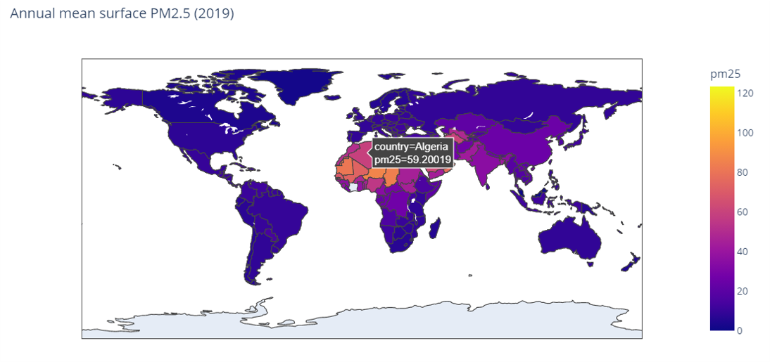
MERRA-2 avgM_2d_pm25_admin0, 2d, Single-Level, Country-Level Surface PM2.5 Monthly Mean Products V1 (M2_TMAX_PM25) at GES DISC
National Aeronautics and Space Administration —
M2_TMAX_PM25 is a value-added product derived from the MERRA-2 aerosol monthly product M2TMNXAER_5.12.4 (or tavgM_2d_aer_Nx). The surface concentration of fine... -
Federal
MERRA-2 statM_2d_edi_Nx: 2d, Single-Level, Monthly Extremes Detection Indices V1 (M2SMNXEDI) at GES DISC
National Aeronautics and Space Administration —
M2SMNXEDI (or statM_2d_edi_Nx) is a 2-dimensional monthly data collection for extreme detection indices derived from daily Modern-Era Retrospective analysis for... -
Federal
MAPSS: Mapped Atmosphere-Plant-Soil System Model, Version 1.0
National Aeronautics and Space Administration —
MAPSS (Mapped Atmosphere-Plant-Soil System) is a landscape to global vegetation distribution model that was developed to simulate the potential biosphere impacts and... -
Federal
Ultraluminous X-Ray Sources in Nearby Galaxies Catalog
National Aeronautics and Space Administration —
One hundred and seven ultraluminous X-ray sources (ULXs) with 0.3-10.0 keV luminosities in excess of 1039 erg s-1 are identified in a complete sample of 127 nearby... -
Federal
KCXX NEXRAD IMPACTS V1
National Aeronautics and Space Administration —
The KCXX NEXRAD IMPACTS dataset consists of Next Generation Weather Radar (NEXRAD) Level II surveillance data that were collected at 31 NEXRAD sites from January 1 to... -
Federal
Global Maps of Atmospheric Nitrogen Deposition, 1860, 1993, and 2050
National Aeronautics and Space Administration —
This data set provides global gridded estimates of atmospheric deposition of total inorganic nitrogen (N), NHx (NH3 and NH4+), and NOy (all oxidized forms of nitrogen...

Official websites use .gov
A
.gov website belongs to an official government
organization in the United States.
Secure .gov websites use HTTPS
A
lock (
) or https:// means you’ve safely connected to
the .gov website. Share sensitive information only on official,
secure websites.