
-
Federal
B00115: NOS Hydrographic Survey , 1987-10-09
National Oceanic and Atmospheric Administration, Department of Commerce —
The National Oceanic and Atmospheric Administration (NOAA) has the statutory mandate to collect hydrographic data in support of nautical chart compilation for safe... -
Federal
B00079: NOS Hydrographic Survey , 1986-10-22
National Oceanic and Atmospheric Administration, Department of Commerce —
The National Oceanic and Atmospheric Administration (NOAA) has the statutory mandate to collect hydrographic data in support of nautical chart compilation for safe... -
Federal
Multibeam collection for RB1201: Multibeam data collected aboard NOAA Ship RONALD H. BROWN (R104) from 18-Feb-12 to 03-Mar-12, Charleston, South Carolina to Charleston, South Carolina
National Oceanic and Atmospheric Administration, Department of Commerce —
This data set is part of a larger set of data called the Multibeam Bathymetry Database (MBBDB) where other similar data can be found -
Federal
OSU SST Climatology V2, MODIS Aqua, West US, 2002-2003, Lon0360
National Oceanic and Atmospheric Administration, Department of Commerce —
This suite of CHLA and SST climatology and anomaly data products are derived from daily, 0.0125 degree x 0.0125 degree, MODIS Aqua CHLA and SST fields that cover the... -
Federal
Wind, Metop-A ASCAT, 0.25°, Global, Near Real Time, 2009-present (14 Day), Lon+/-180
National Oceanic and Atmospheric Administration, Department of Commerce —
NOAA CoastWatch distributes near real time wind data originating with wind velocity measurements from the ASCAT instrument onboard EUMETSAT's Metop-A satellite. ASCAT... -
Federal
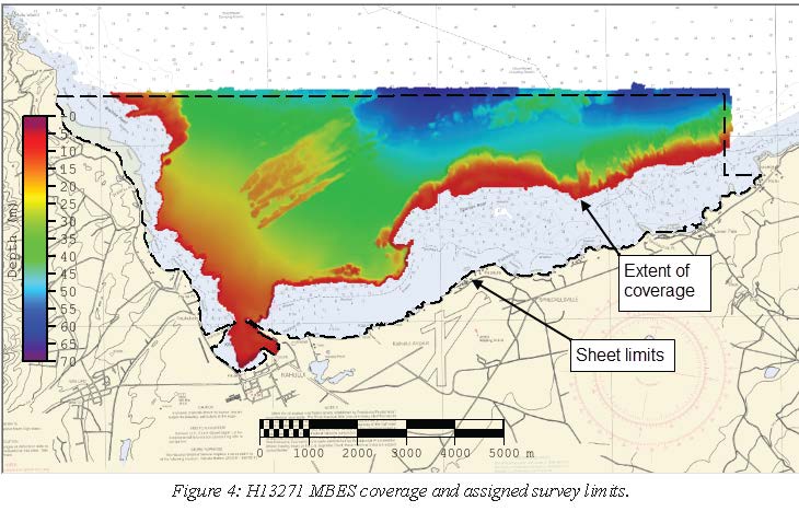
H13271: NOS Hydrographic Survey , 2019-08-08
National Oceanic and Atmospheric Administration, Department of Commerce —
The National Oceanic and Atmospheric Administration (NOAA) has the statutory mandate to collect hydrographic data in support of nautical chart compilation for safe... -
Federal
H11322: NOS Hydrographic Survey , Buzzard Bay and Rhode Island Sound, Rhode Island, 2004-07-16
National Oceanic and Atmospheric Administration, Department of Commerce —
The National Oceanic and Atmospheric Administration (NOAA) has the statutory mandate to collect hydrographic data in support of nautical chart compilation for safe... -
Federal
The NOAA and MMS Marine Minerals Bibliography
National Oceanic and Atmospheric Administration, Department of Commerce —
From 1983 through 1992, the National Oceanic and Atmospheric Administration (NOAA) National Geophysical Data Center (NGDC) compiled a comprehensive, computerized... -
Federal
Multibeam collection for HB1906L4: Multibeam data collected aboard NOAA Ship HENRY B. BIGELOW (R225) from 30-Oct-19 to 14-Nov-19, Newport, Rhode Island to Newport, RI
National Oceanic and Atmospheric Administration, Department of Commerce —
This data set is part of a larger set of data called the Multibeam Bathymetry Database (MBBDB) where other similar data can be found -
Federal
L00957: NOS Hydrographic Survey
National Oceanic and Atmospheric Administration, Department of Commerce —
The National Oceanic and Atmospheric Administration (NOAA) has the statutory mandate to collect hydrographic data in support of nautical chart compilation for safe... -
Federal
AMSR-E/Aqua Daily L3 Global Ascending/Descending .25x.25 deg Ocean Grids V002
National Aeronautics and Space Administration —
The Level-3 daily product (AE_DyOcn), weekly product (AE_WkOcn), and monthly product (AE_MoOcn) include SST, near-surface wind speed, columnar water vapor, and... -
Federal
H01511A: NOS Hydrographic Survey
National Oceanic and Atmospheric Administration, Department of Commerce —
The National Oceanic and Atmospheric Administration (NOAA) has the statutory mandate to collect hydrographic data in support of nautical chart compilation for safe... -
Federal
Hydrographic and Impairment Statistics Database: NPS-WSR Musconetcong Wild and Scenic River
Department of the Interior —
Hydrographic and Impairment Statistics (HIS) is a National Park Service (NPS) Water Resources Division (WRD) project established to track certain goals created in... -
Federal
Multibeam collection for NF2201: Multibeam data collected aboard NOAA Ship NANCY FOSTER (R352) from 14-Mar-22 to 02-Apr-22, San Juan, Puerto Rico to San Juan, Puerto Rico
National Oceanic and Atmospheric Administration, Department of Commerce —
This data set is part of a larger set of data called the Multibeam Bathymetry Database (MBBDB) where other similar data can be found -
Federal
B01 SBE16 - CTD Transmissivity
National Oceanic and Atmospheric Administration, Department of Commerce —
Ocean observation data from the Northeastern Regional Association of Coastal & Ocean Observing Systems (NERACOOS). The NERACOOS region includes the northeast... -
Federal
H06010: NOS Hydrographic Survey , 1934-01-01
National Oceanic and Atmospheric Administration, Department of Commerce —
The National Oceanic and Atmospheric Administration (NOAA) has the statutory mandate to collect hydrographic data in support of nautical chart compilation for safe... -
Federal
nokomis-20190808T1619-delayed
National Oceanic and Atmospheric Administration, Department of Commerce —
Slocum glider data were collected in western Lake Superior to examine nearshore to offshore gradients. The glider collected vertical profiles of conductivity,... -
Federal
NERACOOS Gulf of Maine Ocean Array: Realtime Buoy Observations: C05 Saco Bay
National Oceanic and Atmospheric Administration, Department of Commerce —
Ocean observation data from the Northeastern Regional Association of Coastal & Ocean Observing Systems (NERACOOS). The NERACOOS region includes the northeast... -
Federal
e640sg17-20230528T1737
National Oceanic and Atmospheric Administration, Department of Commerce —
The Predictions of AcousticS with Smart Experimental Networks of GlidERS (PASSENGERS) project is a partnership between universities and the Naval Research Laboratory... -
Federal
Brutus Current Profile Time Series
National Oceanic and Atmospheric Administration, Department of Commerce —
Current profile data from Downward-looking ADCP #00 on FPF Brutus, 2.780000e+01N, 9.067000e+01W, 2007/02/07 00:03 through 2007/09/14 07:28

Official websites use .gov
A
.gov website belongs to an official government
organization in the United States.
Secure .gov websites use HTTPS
A
lock (
) or https:// means you’ve safely connected to
the .gov website. Share sensitive information only on official,
secure websites.
.jpg)