-
Federal
National Coral Reef Monitoring Program: Coral demographic data (adult and juvenile corals, species, colony length, condition, etc.) collected during Stratified Random Surveys (StRS) across the US Pacific since 2013 derived from in-situ diver surveys and structure-from-motion imagery
National Oceanic and Atmospheric Administration, Department of Commerce —
The data described here result from benthic coral demographic surveys within belt transects of specified length and width for two life stages (juveniles and adults)... -
Federal
D00141: NOS Hydrographic Survey , Chandeleur Sound, Louisiana, 2009-01-24
National Oceanic and Atmospheric Administration, Department of Commerce —
The National Oceanic and Atmospheric Administration (NOAA) has the statutory mandate to collect hydrographic data in support of nautical chart compilation for safe... -
Federal
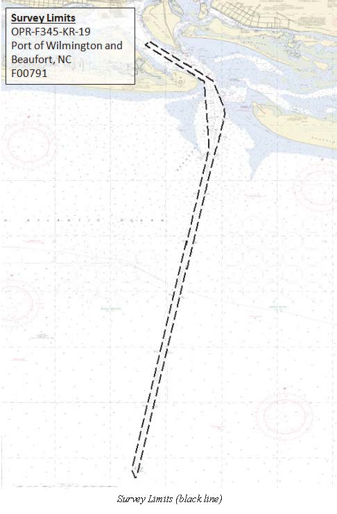
F00791: NOS Hydrographic Survey , 2019-09-09
National Oceanic and Atmospheric Administration, Department of Commerce —
The National Oceanic and Atmospheric Administration (NOAA) has the statutory mandate to collect hydrographic data in support of nautical chart compilation for safe... -
Federal
MODIS/Terra Surface Reflectance 8-Day L3 Global 500m SIN Grid V061
National Aeronautics and Space Administration —
The Moderate Resolution Imaging Spectroradiometer (MODIS) Terra MOD09A1 Version 6.1 product provides an estimate of the surface spectral reflectance of Terra MODIS... -
Federal
NOAA Digital Orthophotography for the Coasts of Massachusetts and Rhode Island
National Oceanic and Atmospheric Administration, Department of Commerce —
Project: NOAA Digital Orthophotography for the Coasts of Main/New Hampshire, Massachusetts/Rhode Island/Connecticut, and Hudson River/Long Island /NY/NJ Contract No.... -
Federal
Aquarius Official Release Level 3 Sea Surface Density Standard Mapped Image Monthly Climatology Data V5.0
National Aeronautics and Space Administration —
Aquarius Level 3 sea surface density standard mapped image data contains gridded 1 degree spatial resolution derived density averaged over daily, 7 day, monthly, and... -
Federal
CERES Monthly Daytime Mean Regionally Averaged NOAA-20 TOA Fluxes and Associated Cloud Properties Stratified by Optical Depth and Effective Pressure Edition1B
National Aeronautics and Space Administration —
CER_FluxByCldTyp-Month_NOAA20-VIIRS_Edition1B is the Clouds and the Earth's Radiant Energy System (CERES) Monthly Daytime Mean Regionally Averaged NOAA-20 Top-of-... -
Federal
GL_LAKE_ERIE_2022 ESI FISH Polygons, Points
National Oceanic and Atmospheric Administration, Department of Commerce —
These feature classes reside within the BIOLOGY Feature Data Set of the Lake Erie - 2022 ESI Geodatabase. It contains vector polygons and points representing FISH... -
Federal
2020 Cartographic Boundary File (KML), Current State Legislative District-Lower Chamber for Tennessee, 1:500,000
U.S. Census Bureau, Department of Commerce —
The 2020 cartographic boundary KMLs are simplified representations of selected geographic areas from the U.S. Census Bureau's Master Address File / Topologically... -
Federal
Aquarius Official Release Level 3 Ancillary Reynolds Sea Surface Temperature Standard Mapped Image Ascending Monthly Climatology Data V5.0
National Aeronautics and Space Administration —
Aquarius Level 3 ancillary sea surface temperature (SST) standard mapped image data are the ancillary SST data used in the Aquarius calibration for salinity... -
State
Drinking Water - Laboratory Water Quality Results
State of California —
The Division of Drinking Water requires laboratories to submit water quality data directly. The data is received, and published twice monthly on the Division's water... -
Federal
PetroQuip - Engineering Design and Specification Document for LBP and LP
Department of Energy —
This document provides the applications, specifications, testing, materials, and running methods for the engineering team at PertoQuip to design the Locking Bridge... -
Federal
IBEX High Energy Neutral Atom Imager (ENA-Lo) Data Release 10, not Compton-Getting corrected, not Survival Probability corrected, Omnidirectional, West Longitude Ecliptic Maps, Level H3 (H3), 7 year average Data
National Aeronautics and Space Administration —
The IBEX ENA-Hi and IBEX ENA-Lo data sets are from Release 10 of all-sky map data for the first seven years, 2009-2015, in the form of omni direction Hydrogen, H,... -
City
2018 Kindergarten Directory - Staten Island
City of New York —
2018 Staten Island Kindergarten Directory -
Federal
GHRSST Level 2P Regional 1m Sea Surface Temperature from the Advanced Very High Resolution Radiometer (AVHRR) on the NOAA-19 satellite produced by NAVO
National Aeronautics and Space Administration —
A regional Group for High Resolution Sea Surface Temperature (GHRSST) Level 2P dataset based on multi-channel sea surface temperature (SST) retrievals generated in... -
Federal
November 2010 Most Probable 24-Month Study
Department of the Interior —
The Most Probable 24-Month Study report describes projected operations and power generation for Colorado River system reservoirs including Fontenelle, Flaming Gorge,... -
Federal
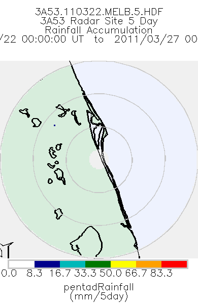
TRMM Ground Validation Radar Site Rain Totals Map L3 5 days 2 km V7 (TRMM_3A53) at GES DISC
National Aeronautics and Space Administration —
This is the 5-day accumulation of the 2A53 product, 'Radar Site Rain Map', which originally is an instantaneous surface rain rate map in Cartesian coordinates with a... -
Federal
Department of Veterans Affairs Freedom of Information Act (FOIA) Report for Fiscal Year 2005
Department of Veterans Affairs —
This is the Department of Veterans Affairs, Freedom of Information Act (FOIA) Report for Fiscal Year 2005. The report contains metrics on FOIA requests received,... -
Federal
GL_LAKE_ERIE_2022 ESI SOCECON Polygons, Points
National Oceanic and Atmospheric Administration, Department of Commerce —
These feature classes reside within the SOCECON Feature Data Set of the Lake Erie - 2022 ESI Geodatabase. They contain vector polygons and points representing...

Official websites use .gov
A
.gov website belongs to an official government
organization in the United States.
Secure .gov websites use HTTPS
A
lock (
) or https:// means you’ve safely connected to
the .gov website. Share sensitive information only on official,
secure websites.