
-
Federal
Western Arctic Shelf-Basin Interactions (SBI) experiment
National Aeronautics and Space Administration —
The Western Arctic Shelf-Basin Interactions (SBI) experiment contains measurements made in the Chukchi and Beaufort seas off the coast of northern Alaska. SBI at the... -
Federal
SMEX04 Soil Climate Analysis Network (SCAN) Data: Arizona, Version 1
National Aeronautics and Space Administration —
Notice to Data Users: The documentation for this data set was provided solely by the Principal Investigator(s) and was not further developed, thoroughly reviewed, or... -
Federal
SENTINEL-1B_DUAL_POL_METADATA_GRD_HIGH_RES
National Aeronautics and Space Administration —
Sentinel-1B Dual-pol ground projected high and full resolution metadata -
Federal
TRMM Radar Rain Distributions L3 1 month 5 degree x 5 degree V7 (TRMM_3A26) at GES DISC
National Aeronautics and Space Administration —
The new version of these data is in GPM-like format (consistent with the GPM Dual-frequency Radar data format), and can be found under the name GPM_3PR. This dataset... -
Federal
TCTE Level 3 Total Solar Irradiance Daily Means V004 (TCTE3TSID) at GES DISC
National Aeronautics and Space Administration —
TCTE3TSID Version 004 is the final version of this data product, and supersedes all previous versions. The Total Solar Irradiance (TSI) Calibration Transfer... -
Federal
Sentinel-1C Single Polarization Medium Resolution Ground Range Detected Product
National Aeronautics and Space Administration —
The Sentinel-1C satellite was launched December 5, 2024. Sentinel-1C is the the latest satellite to be added to the Sentinel-1 constellation. The Sentinel-1... -
Federal
KORUS-AQ Ozonesonde Data
National Aeronautics and Space Administration —
KORUSAQ_Sondes_Data features data collected via ozonesonde launches at Olympic Park and Taehwa during the KORUS-AQ field campaign. Data collection for this product is... -
Federal
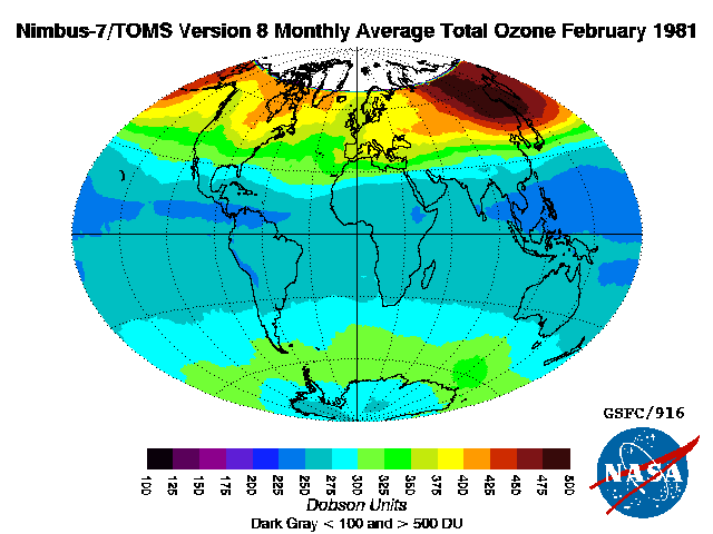
TOMS Nimbus-7 Total Column Ozone Monthly L3 Global 1 deg x 1.25 deg Lat/Lon Grid V008 (TOMSN7L3mtoz) at GES DISC
National Aeronautics and Space Administration —
This Nimbus-7 Total Ozone Mapping Spectrometer (TOMS) version 8 monthly averaged global gridded data product contains total column ozone values. The data are mapped... -
Federal
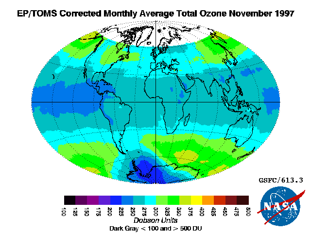
TOMS Earth Probe Total Column Ozone Monthly L3 Global 1 deg x 1.25 deg Lat/Lon Grid V008 (TOMSEPL3mtoz) at GES DISC
National Aeronautics and Space Administration —
This Earth Probe (EP) Total Ozone Mapping Spectrometer (TOMS) version 8 monthly averaged global gridded data product contains total column ozone values. The data are... -
Federal
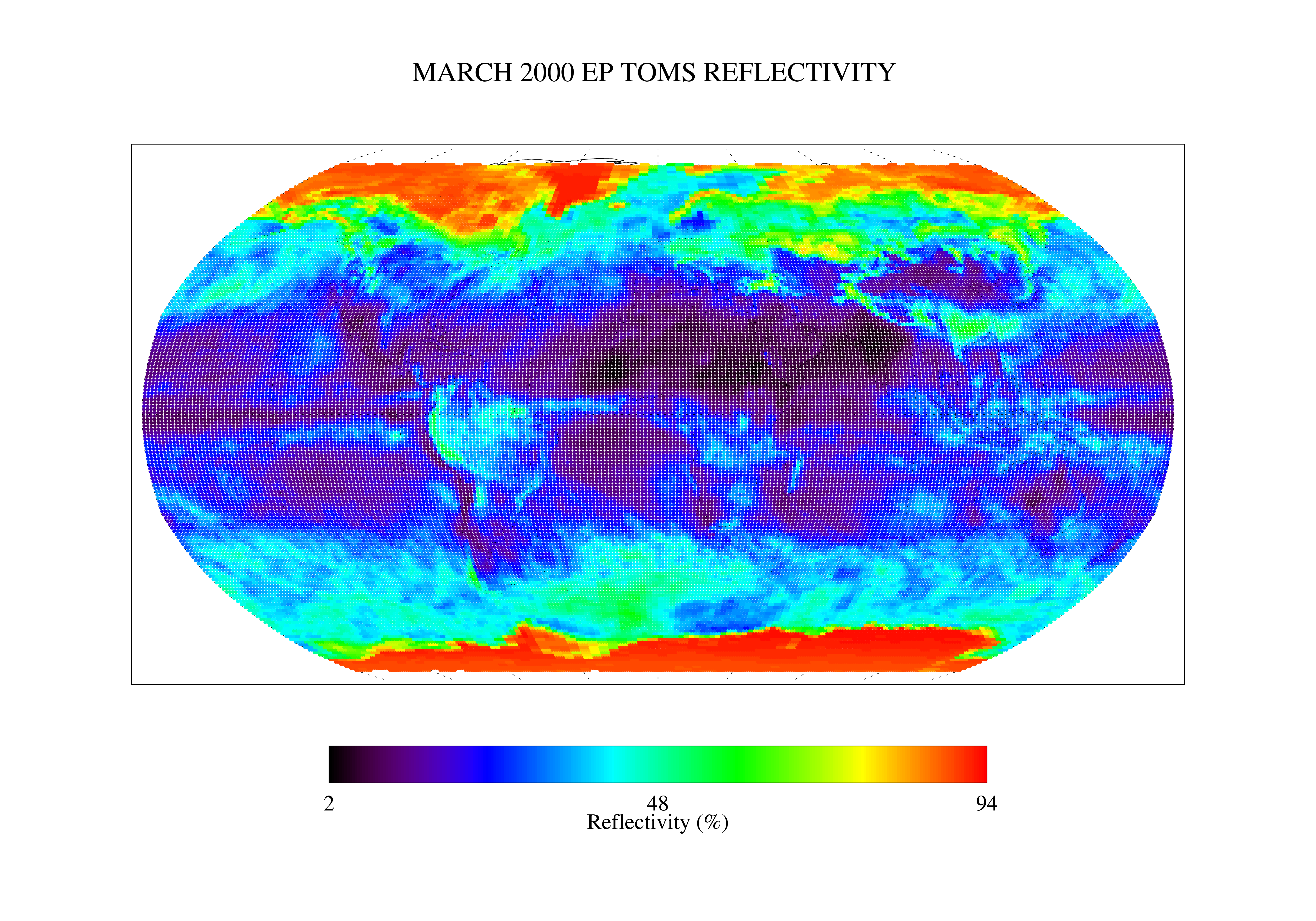
TOMS Earth Probe UV Reflectivity Monthly L3 Global 1 deg x 1.25 deg Lat/Lon Grid V008 (TOMSEPL3mref) at GES DISC
National Aeronautics and Space Administration —
This Earth Probe (EP) Total Ozone Mapping Spectrometer (TOMS) version 8 monthly averaged global gridded data product contains Lambertian effective surface... -
Federal
Tropical Ozone Transport Experiment – Vortex Ozone Transport Experiment (TOTE-VOTE) DC-8 In Situ Aerosol Data
National Aeronautics and Space Administration —
TOTE-VOTE_Aerosol_AircraftInSitu_DC8_Data_1 is the in situ collected onboard the DC-8 aircraft during the Tropical Ozone Transport Experiment – Vortex Ozone Transport... -
Federal
TRMM Ground Validation Calibrated QC Radar Reflectivity Full Volume Scan L1C 1 hour V7 (TRMM_1C51UW) at GES DISC
National Aeronautics and Space Administration —
This dataset is part of the University of Washington TRMM Ground Validation products. Files are in "Universal Format", described in BAMS, Vol 61, No 11, November... -
Federal
GEWEX SRB Integrated Product (Rel-4) Shortwave Monthly Average by Local Fluxes
National Aeronautics and Space Administration —
GEWEXSRB_Rel4-IP_Shortwave_monthly_local is the Global Energy and Water Exchanges (GEWEX) Surface Radiation Budget (SRB) Integrated Product (Rel-4) Shortwave Monthly... -
Federal
GPM SSMIS on F17 (GPROF) Radiometer Precipitation Profiling L3 1 day 0.25 degree x 0.25 degree V07 (GPM_3GPROFF17SSMIS_DAY) at GES DISC
National Aeronautics and Space Administration —
Version 07 is the current version of the data set. Older versions will no longer be available and have been superseded by Version 07. 3GPROF products provide global... -
Federal
GPM AMSUB on NOAA15 (GPROF) Climate-based Radiometer Precipitation Profiling L3 1 day 0.25 degree x 0.25 degree V07 (GPM_3GPROFNOAA15AMSUB_DAY_CLIM) at GES DISC
National Aeronautics and Space Administration —
The "CLIM" products differ from their "regular" counterparts (without the "CLIM" in the name) by the ancillary data they use. They are Climate-Reference products,... -
Federal
SEDIMENT ANALYSIS NETWORK FOR DECISION SUPPORT (SANDS) MODIS GEOLOGICAL SURVEY OF AL (GSA) ANALYSIS V1
National Aeronautics and Space Administration —
The Sediment Analysis Network for Decision Support (SANDS) MODIS Geological Survey of AL (GSA) Analysis dataset consists of geoTIFF images were analyzed for sediment... -
Federal
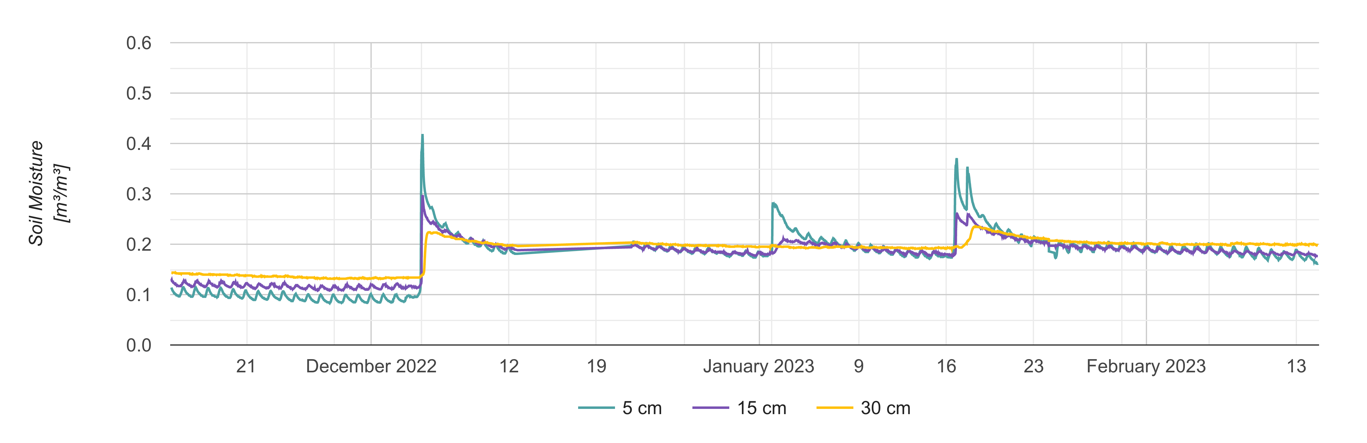
Soil Moisture Profiles and Temperature Data from SoilSCAPE Sites, Version 2
National Aeronautics and Space Administration —
This dataset contains in-situ soil moisture profile and soil temperature data collected at 30-minute intervals at SoilSCAPE (Soil moisture Sensing Controller and... -
Federal
SENTINEL-1A_RAW
National Aeronautics and Space Administration —
Sentinel-1A level zero product -
Federal
CARVE: Fire-Related Aerosol and Soil Elemental and Isotopic Composition, Alaska, 2013
National Aeronautics and Space Administration —
This data set provides measurements of the isotopic composition of black carbon and organic carbon aerosols collected at two locations in interior Alaska during the... -
Federal
ASTER L2 Surface Reflectance VNIR and Crosstalk Corrected SWIR V004
National Aeronautics and Space Administration —
The Terra Advanced Spaceborne Thermal Emission and Reflection Radiometer (ASTER) Surface Reflectance VNIR and Crosstalk Corrected SWIR (AST_07XT) dataset contains...

Official websites use .gov
A
.gov website belongs to an official government
organization in the United States.
Secure .gov websites use HTTPS
A
lock (
) or https:// means you’ve safely connected to
the .gov website. Share sensitive information only on official,
secure websites.