
-
Federal
Land Cover and Land Use Classification for the State of New Hampshire, 1996-2001
National Aeronautics and Space Administration —
The New Hampshire Geographically Referenced Analysis and Information Transfer System (GRANIT) land cover data set provides a land cover and land use product at 30-m... -
Federal
Investigaciones Mexicanas de la Corriente de California (IMECOCAL)
National Aeronautics and Space Administration —
Measurements made under the IMECOCAL program (Investigaciones Mexicanas de la Corriente de California, translated: Mexican Research of the California Current) from... -
Federal
JPSS-1 CrIS Level 1B Principal Component Analysis / Rapid Event Detection V3.0 (SNDRJ1CrISL1BPCARED) at GES DISC
National Aeronautics and Space Administration —
This sample data collection contains L1B radiance values that are compressed and denoised via Principal Component Analysis (PCA). Additionally it contains a new Rapid... -
Federal
KORUS-AQ Miscellaneous Data
National Aeronautics and Space Administration —
KORUSAQ_Miscellaneous_Data are miscellaneous ancillary files collected during the KORUS-AQ field campaign. This product includes data collected onboard the UMD Cessna... -
Federal
International Satellite Cloud Climatology Project (ISCCP) Stage D2 Monthly Cloud Products - Revised Algorithm in Hierarchical Data Format
National Aeronautics and Space Administration —
The ISCCP_D2 data set contains monthly, 280 KM equal-area grid data from various polar and geostationary satellites. Climatological Summary Product contents contain... -
Federal
Electromagnetic Interference Measurements from Tungsten Inert Gas (TIG) Arc Welding
National Institute of Standards and Technology —
The 2.4 GHz ISM band is shared by Wi-Fi, Bluetooth, Wireless HART, ISA100.11a, and several other industrial wireless systems. Our dataset contains comprehensive... -
Federal
OMG Narwhals Shipboard Conductivity, Temperature, and Depth (CTD) profiles, 2018-2020
National Aeronautics and Space Administration —
This OMG Narwhals dataset contains measurements from the ship based full water column CTD profiles that were obtained during summer mooring deployment/recovery... -
Federal
SEAC4RS DC-8 Aircraft In-Situ Aerosol Data
National Aeronautics and Space Administration —
SEAC4RS_Aerosol_AircraftInSitu_DC8_Data are in-situ aerosol data collected onboard the DC8 aircraft during the Studies of Emissions and Atmospheric Composition,... -
Federal
OMI/Aura Near UV Aerosol Optical Depth and Single Scattering Albedo 1-orbit L2 Swath 13x24 km V004 (OMAERUV) at GES DISC
National Aeronautics and Space Administration —
The Aura Ozone Monitoring Instrument level-2 near UV Aerosol data product OMAERUV (Version 004) is available from the NASA Goddard Earth Sciences Data and Information... -
Federal
Sentinel-1 Interferograms
National Aeronautics and Space Administration —
Sentinel-1 SLC interferometric products generated by JPL using ISCE v2.0.0, delivered by ASF -
Federal
SEAC4RS Merge Data Files
National Aeronautics and Space Administration —
SEAC4RS_Merge_Data are pre-generated merge data files collected during the Studies of Emissions and Atmospheric Composition, Clouds and Climate Coupling by Regional... -
Federal
MODIS/Terra Vegetation Indices 16-Day L3 Global 250m SIN Grid V006
National Aeronautics and Space Administration —
The MOD13Q1 Version 6 data product was decommissioned on July 31, 2023. Users are encouraged to use the MOD13Q1... -
Federal
MuSLI Multi-Source Land Surface Phenology Yearly North America 30 m V011
National Aeronautics and Space Administration —
The Multi-Source Land Surface Phenology (LSP) Yearly North America 30 meter (m) Version 1.1 product (MSLSP) provides a Land Surface Phenology product for North... -
Federal
MISR Derived Case Study Data for Iceland Volcanic Eruptions (Eyjafjallajokull, Grimsvotn, Holuhraun) Including Geometric Plume Height and Qualitative Radiometric Particle Property Information
National Aeronautics and Space Administration —
This dataset comprises MISR-derived output from a comprehensive analysis of Icelandic volcano eruptions (Eyjafjallajokull 2010, Grimsvotn 2011, Holuhraun 2014-2015).... -
Federal
NOAA-20 VIIRS Level-3 Global Mapped 11µm Nighttime Sea Surface Temperature (NSST) Data, version R2024.0
National Aeronautics and Space Administration —
The Visible and Infrared Imager/Radiometer Suite (VIIRS) is a multi-disciplinary instrument that is being flown on the Joint Polar Satellite System (JPSS) series of... -
Federal
NPP Grassland: Shortandy, Kazakhstan, 1977-1980, R1
National Aeronautics and Space Administration —
This data set provides two data files in text format (.txt). One file contains biomass measurements and cumulative ANPP calculations made between 1977 and 1980 on a... -
Federal
MODIS/Terra Land Surface Temperature/Emissivity Monthly L3 Global 0.05Deg CMG V061
National Aeronautics and Space Administration —
The Terra Moderate Resolution Imaging Spectroradiometer (MODIS) Land Surface Temperature/Emissivity Monthly(MOD11C3) Version 6.1 product provides monthly Land Surface... -
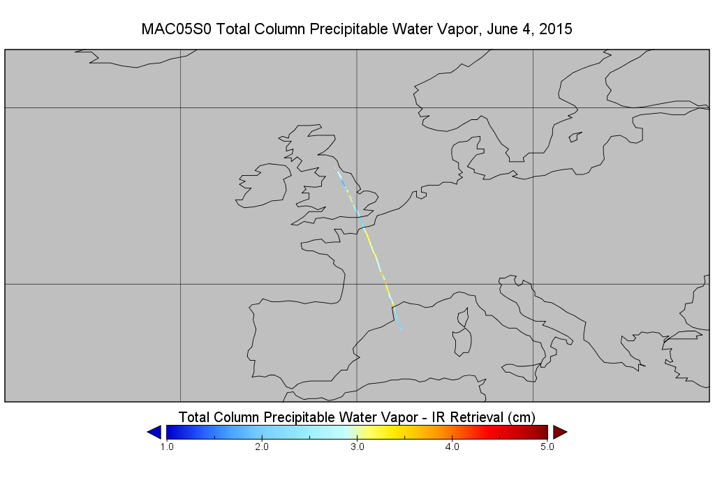
Federal
MODIS/Aqua Total Precip Water Vapor 1km and 5km 5-Min L2 Narrow Swath Subset along CloudSat V002 (MAC05S0) at GES DISC
National Aeronautics and Space Administration —
This is the narrow-swath MODIS/Aqua subset along CloudSat field of view track. The goal of the narrow-swath subset is to select and return MODIS data that are within... -
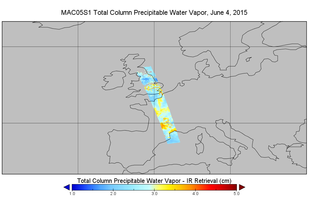
Federal
MODIS/Aqua Total Precip Water Vapor 1km and 5km 5-Min L2 Wide Swath Subset along CloudSat V002 (MAC05S1) at GES DISC
National Aeronautics and Space Administration —
This is the wide-swath MODIS/Aqua subset along CloudSat field of view track. The goal of the wide-swath subset is to select and return MODIS data that are within...

Official websites use .gov
A
.gov website belongs to an official government
organization in the United States.
Secure .gov websites use HTTPS
A
lock (
) or https:// means you’ve safely connected to
the .gov website. Share sensitive information only on official,
secure websites.