
-
State
Geology of Kasatochi volcano, Aleutian Islands, Alaska
State of Alaska —
Kasatochi is a small, isolated island volcano in the center of the Aleutian Island chain. It consists of a roughly circular cone approximately 3 km in diameter with a... -
Federal
Aquarius L3 Gridded 1-Degree Seasonal Soil Moisture Climatology V005
National Aeronautics and Space Administration —
This data set contains Level-3 gridded seasonal global soil moisture climatology estimates derived from the NASA Aquarius passive microwave radiometer on the Satélite... -
Federal
SnowEx Meteorological Station Measurements from Grand Mesa, CO V001
National Aeronautics and Space Administration —
This dataset contains meteorological data collected as part of the ongoing the NASA SnowEx mission, from five meteorological stations installed between 2016-2017 in... -
Federal
SMAP L4 Global 9 km EASE-Grid Surface and Root Zone Soil Moisture Land Model Constants V007
National Aeronautics and Space Administration —
SMAP Level-4 (L4) surface and root zone soil moisture data are provided in three products: * SMAP L4 Global 3-hourly 9 km EASE-Grid Surface and Root Zone Soil... -
University
Soil Survey Geographic (SSURGO) database for Cabezon Area, New Mexico (Sandoval County, New Mexico)
Earth Data Analysis Center, University of New Mexico —
This data set is a digital soil survey and generally is the most detailed level of soil geographic data developed by the National Cooperative Soil Survey. The... -
Federal
Jornada Basin LTER: Wireless meteorological station at NPP G-BASN site: 30-minute soil volumetric water content data: 2013 - ongoing
Department of Agriculture —
30-minute Soil Moisture data at NPP G-BASN met station. Collection of soil volumetric water content data at Jornada LTER NPP sites, New Mexico, supports the... -
Federal
SMAPVEX19-22 Massachusetts Vegetation Optical Depth V001
National Aeronautics and Space Administration —
As part of the SMAPVEX19-22 campaign, an L-band radiometer was deployed on top of a tower at Harvard Forest,Massachusetts, looking down at a stand of red oak forest.... -
Federal
SMAPVEX16 Manitoba Station Soil Moisture Data V001
National Aeronautics and Space Administration —
This data set contains soil moisture, temperature, and precipitation data collected at temporary soil stations and the Real-time In-Situ Soil Monitoring for... -
Federal
R-Factor for the Island of Puerto Rico
National Oceanic and Atmospheric Administration, Department of Commerce —
The rainfall-runoff erosivity factor (R-Factor) quantifies the effects of raindrop impacts and reflects the amount and rate of runoff associated with the rain. The... -
Federal
SMAPVEX16 Iowa PALS Brightness Temperature and Soil Moisture Data V001
National Aeronautics and Space Administration —
This product contains data derived from permanent in situ soil stations and observations by the Passive Active L-band System (PALS) microwave aircraft instrument. The... -
Federal
SMAPVEX16 Manitoba Core-Based In Situ Soil Moisture Data V001
National Aeronautics and Space Administration —
This data set contains in situ measurements of soil moisture and bulk density collected for the Soil Moisture Active Passive Validation Experiment 2016 Manitoba... -
Federal
NLCD 1992/2001 Retrofit Land Cover Change Product
National Aeronautics and Space Administration —
Developments in mapping methodology, new sources of input data, and changes in the mapping legend for the 2001 National Land Cover Database (NLCD2001) will confound... -
University
Soil Survey Geographic (SSURGO) database for Jicarilla Apache Nation, Parts of Rio Arriba and Sandoval Counties, New Mexico
Earth Data Analysis Center, University of New Mexico —
This data set is a digital soil survey and generally is the most detailed level of soil geographic data developed by the National Cooperative Soil Survey. The... -
University
Soil Survey Geographic (SSURGO) database for Fort Bliss Military Reservation, New Mexico and Texas
Earth Data Analysis Center, University of New Mexico —
This data set is a digital soil survey and generally is the most detailed level of soil geographic data developed by the National Cooperative Soil Survey. The... -
Federal
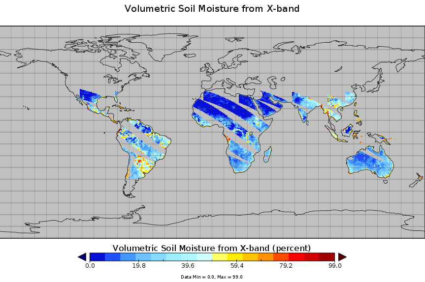
TMI/TRMM surface soil moisture (LPRM) L3 1 day 25 km x 25 km nighttime V001 (LPRM_TMI_NT_SOILM3) at GES DISC
National Aeronautics and Space Administration —
TMI/TRMM surface soil moisture (LPRM) L3 1 day 25 km x 25 km nighttime V001 is Level 3 (gridded) data set. Its land surface parameters, surface soil moisture, land... -
Federal
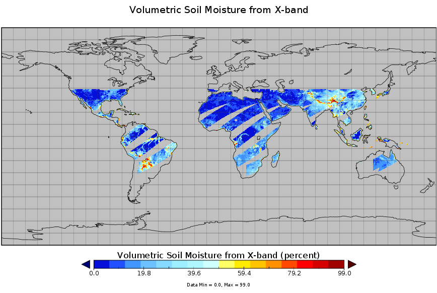
TMI/TRMM surface soil moisture (LPRM) L3 1 day 25 km x 25 km daytime V001 (LPRM_TMI_DY_SOILM3) at GES DISC
National Aeronautics and Space Administration —
TMI/TRMM surface soil moisture (LPRM) L3 1 day 25 km x 25 km daytime V001 is a Level 3 (gridded) data set. Its land surface parameters, surface soil moisture, land... -
Federal
Water Availability Tool for Environmental Resources for the Commonwealth of Kentucky updated for 2019 - Land-Cover, Waterbodies and Topography
Department of the Interior —
These data include land-cover, water bodies, and topographic data. -
Federal
Aquarius L3 Gridded 1-Degree Monthly Soil Moisture V005
National Aeronautics and Space Administration —
This data set contains Level-3 gridded monthly global soil moisture estimates derived from the NASA Aquarius passive microwave radiometer on the Satélite de... -
Federal
SMAPVEX19-22 Millbrook Temporary Soil Moisture Network V001
National Aeronautics and Space Administration —
These data consist of soil moisture sensor, soil temperature and air temperature measurements recorded by 25 temporary stations in the Millbrook (MB) experiment... -
University
Soil Survey Geographic (SSURGO) database for Sandoval County Area, New Mexico (Parts of Los Alamos, Sandoval and Rio Arriba Counties)
Earth Data Analysis Center, University of New Mexico —
This data set is a digital soil survey and generally is the most detailed level of soil geographic data developed by the National Cooperative Soil Survey. The...

Official websites use .gov
A
.gov website belongs to an official government
organization in the United States.
Secure .gov websites use HTTPS
A
lock (
) or https:// means you’ve safely connected to
the .gov website. Share sensitive information only on official,
secure websites.