

119 datasets found
-
Federal
International Space Station SERVIR Environmental Research and Visualization System V1
National Aeronautics and Space Administration —
Abstract: The ISS SERVIR Environmental Research and Visualization System (ISERV) acquired images of the Earth's surface from the International Space Station (ISS).... -
Federal
Landsat 8 Collection 1 Level-2 Scene Products (Surface Reflectance)
Department of the Interior —
The USGS Earth Resources Observation and Science (EROS) Center archive holds data collected by the Landsat suite of satellites, beginning with Landsat 1 in 1972. All... -
Federal
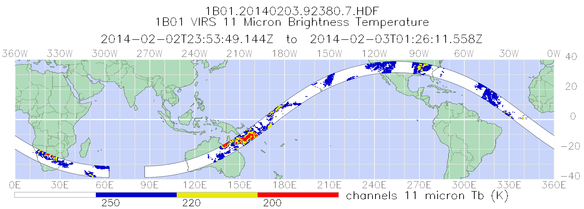
TRMM Visible and Infrared Scanner Calibrated Radiances L1B 1.5 hours V7 (TRMM_1B01) at GES DISC
National Aeronautics and Space Administration —
This TRMM Visible and Infrared Scanner (VIRS) Level 1B Calibrated Radiance Product (1B01) contains calibrated radiances and auxiliary geolocation information from the... -
Federal
IceBridge LVIS L1A Geotagged Images V001
National Aeronautics and Space Administration —
This data set contains geotagged images taken over Greenland and Antarctica by the NASA Digital Mapping Camera paired with the Land, Vegetation, and Ice Sensor... -
Federal
Landsat 4-5 Thematic Mapper Collection 1 Level-1
Department of the Interior —
The USGS Earth Resources Observation and Science (EROS) Center archive holds data collected by the Landsat suite of satellites, beginning with Landsat 1 in 1972. All... -
Federal
TRMM Visible and Infrared Scanner Calibrated Radiances L1B 1.5 hours V7 (TRMM_1B01) at GES DISC
National Aeronautics and Space Administration —
This TRMM Visible and Infrared Scanner (VIRS) Level 1B Calibrated Radiance Product (1B01) contains calibrated radiances and auxiliary geolocation information from the... -
Federal
Landsat 7 Enhanced Thematic Mapper Plus Collection 1 Level-1
Department of the Interior —
The USGS Earth Resources Observation and Science (EROS) Center archive holds data collected by the Landsat suite of satellites, beginning with Landsat 1 in 1972. All... -
Federal
Landsat 4-5 Thematic Mapper Film Only: 1982-1988
Department of the Interior —
'The USGS Earth Resources Observation and Science (EROS) Center archive holds data collected by the Landsat suite of satellites. The Landsat Thematic Mapper (TM), a... -
Federal
Landsat 4-5 Collection 1 Level-2 Scene Products (Surface Reflectance)
Department of the Interior —
The USGS Earth Resources Observation and Science (EROS) Center archive holds data collected by Landsat 4 and 5. All Landsat data held in the USGS EROS archive are... -
Federal
Multi-Resolution Land Characteristics
National Aeronautics and Space Administration —
The Multi-Resolution Land Characteristics (MRLC) project was established to provide multi-resolution land cover data of the conterminous United States from local to... -
Federal
Landsat 7 Collection 1 Level-2 Scene Products (Surface Reflectance)
Department of the Interior —
The USGS Earth Resources Observation and Science (EROS) Center archive holds data collected by the Landsat suite of satellites, beginning with Landsat 1 in 1972. All... -
Federal
Advanced Spaceborne Thermal Emission and Reflection Radiometer (ASTER) NGDA
National Aeronautics and Space Administration —
This dataset represents multiple products archived at the Land Processes DAAC for ASTER (Advanced Spaceborne Thermal Emission and Reflection Radiometer) aboard the... -
Federal
OLCI+SLSTR/Sentinel-3A L2 Surface Reflectance and Aerosol parameters over Land
National Aeronautics and Space Administration —
The OLCI+SLSTR/Sentinel-3A L2 Surface Reflectance and Aerosol parameters over Land product with shortname S3A_SY_2_SYN, is generated by combining data acquired by the... -
Federal
OLCI/Sentinel-3B L1 Full Resolution Top of Atmosphere Reflectance
National Aeronautics and Space Administration —
The OLCI/Sentinel-3B L1 Full Resolution Top of Atmosphere Reflectance product, S3B_OL_1_EFR is generated from the data aquired by the Ocean and Land Colour Instrument... -
Federal
MASTER: BP Oil Spill Mapping, Louisiana-Gulf of Mexico-Wisconsin, Fall, 2010
National Aeronautics and Space Administration —
This dataset includes Level 1B (L1B) and Level 2 (L2) data products from the MODIS/ASTER Airborne Simulator (MASTER) instrument. The raw data were collected during 9... -
Federal
GPM GROUND VALIDATION DC-8 CAMERA NADIR GCPEX V1
National Aeronautics and Space Administration —
The GPM Ground Validation DC-8 Camera Nadir GCPEx dataset contains geo-located, visible-wavelength imagery of the ground obtained from the nadir camera aboard the... -
Federal
AVHRR 1-km Global Land 10-Day Composites
National Aeronautics and Space Administration —
The Advanced Very High Resolution Radiometer (AVHRR) 1-km Global Land 10-Day Composites data set project is a component of the National Aeronautics and Space... -
Federal
IceBridge DMS L3 Photogrammetric DEM V001
National Aeronautics and Space Administration —
The IceBridge DMS L3 Photogrammetric DEM (IODMS3) data set contains gridded digital elevation models and orthorectified images of Greenland and Antarctica derived...
119 datasets found