
-
Federal
Visible Infrared Imaging Radiometer Suite (VIIRS) Global Area Coverage (VGAC), Version 1
National Oceanic and Atmospheric Administration, Department of Commerce —
The Visible Infrared Imaging Radiometer Suite (VIIRS) instrument represents a significant change from the historical weather satellite observations. For example,... -
Federal
Coking coal of the United States: Modern and historical locations of coking coal mining locations and chemical, rheological, petrographic, and other data from modern samples
Department of the Interior —
For the open-file report we collected new coking coal samples from Alabama, Kentucky, Oklahoma and Arkansas and analyzed them for proximate and ultimate analyses;... -
Federal
NOAA Climate Data Record (CDR) of AVHRR Surface Reflectance, Version 5
National Oceanic and Atmospheric Administration, Department of Commerce —
This dataset contains gridded daily surface reflectance and brightness temperatures derived from the Advanced Very High Resolution Radiometer (AVHRR) sensors onboard... -
Federal
Remote Sensing Reflectance at 667 nm, Aqua MODIS, NPP, Gulf of Mexico, 2002-2012 (3 Day Composite), Lon0360
National Oceanic and Atmospheric Administration, Department of Commerce —
MODIS measures the remote sensing reflectance (Rrs) at 667nm. This can be used to view very high concentrations of phytoplankton in the very surface of the water. -
Federal
VIIRSN, Suomi-NPP, Level-3 SMI, NASA, Global, 4km, Reflectance at 671 nm, R2018, 2012-present, 8-Day, Lon0360
National Oceanic and Atmospheric Administration, Department of Commerce —
R2018 of Level-3 Standard Mapped Image (SMI), Global, 4km, Remote Sensing Reflectance at 671 nm, 8-Day composite data from the Visible and Infrared Imager/Radiometer... -
Federal
VIIRSN, Suomi-NPP, Level-3 SMI, NASA, Global, 4km, Reflectance at 671 nm, v2016, 2012-2017, Monthly, DEPRECATED, Lon0360
National Oceanic and Atmospheric Administration, Department of Commerce —
THIS VERSION WAS DISCONTINUED on 2017-12-01. SEE THE NEW erdVH2018 DATASETS. Level-3 Standard Mapped Image (SMI), Global, 4km, Remote Sensing Reflectance at 671 nm,... -
Federal
VIIRSN, Suomi-NPP, Level-3 SMI, NASA, Global, 4km, Reflectance at 671 nm, R2018, 2012-present, Daily
National Oceanic and Atmospheric Administration, Department of Commerce —
R2018 of Level-3 Standard Mapped Image (SMI), Global, 4km, Remote Sensing Reflectance at 671 nm, Daily composite data from the Visible and Infrared Imager/Radiometer... -
Federal
Remote Sensing Reflectance at 667 nm, Aqua MODIS, NPP, Gulf of Mexico, 2002-2012 (14 Day Composite), Lon0360
National Oceanic and Atmospheric Administration, Department of Commerce —
MODIS measures the remote sensing reflectance (Rrs) at 667nm. This can be used to view very high concentrations of phytoplankton in the very surface of the water. -
Federal
Multispectral structure-from-motion digital elevation and reflectance orthomosaic data products from Uncrewed Aircraft System (UAS) surveys of dryland sites 40 km south of Moab, Utah in May 2023
Department of the Interior —
In support of U.S. Geological Survey (USGS) Southwest Biological Science Center researchers, and in coordination with the Bureau of Land Management (BLM) and National... -
Federal
Jornada Basin LTER: Wireless meteorological station at NPP C-SAND site: Daily summary data: 2013 - ongoing
Department of Agriculture —
Daily summary data at NPP C-SAND met station. Average/maximum/minimum air temperature; average/maximum relative humidity and wind speed and average wind direction;... -
Federal
Remote Sensing Reflectance at 667 nm, Terra MODIS, NPP, Global, 2000-2013, Science Quality (8 Day Composite), Lon+/-180
National Oceanic and Atmospheric Administration, Department of Commerce —
MODIS measures the remote sensing reflectance (Rrs) at 667nm. This can be used to view very high concentrations of phytoplankton in the very surface of the water. -
Federal
VIIRSN, Suomi-NPP, Level-3 SMI, NASA, Global, 4km, Reflectance at 671 nm, R2018, 2012-present, 8-Day
National Oceanic and Atmospheric Administration, Department of Commerce —
R2018 of Level-3 Standard Mapped Image (SMI), Global, 4km, Remote Sensing Reflectance at 671 nm, 8-Day composite data from the Visible and Infrared Imager/Radiometer... -
Federal
NOAA Climate Data Record (CDR) of Gridded Satellite Data from ISCCP B1 (GridSat-B1) Infrared Channel Brightness Temperature, Version 2
National Oceanic and Atmospheric Administration, Department of Commerce —
The Gridded Satellite (GridSat-B1) data provides a uniform set of quality controlled geostationary satellite observations for the visible, infrared window and... -
Federal
C-HARM v2 2-Day Forecast, Pseudo-nitzschia, cellular domoic acid, and particular domoic acid probability, California and Southern Oregon coast, 2022-present, Lon+/-180
National Oceanic and Atmospheric Administration, Department of Commerce —
The C-HARM model generates nowcast and forecasts of the probability of Pseudo-nitzschia concentrations of in excess of 10,000 cells/L, the probability of particulate... -
Federal
Field spectra from the Snake River in Grand Teton National Park, WY, August 23, 2015
Department of the Interior —
Field spectra were collected from the Snake River in Grand Teton National Park, WY, August 23, 2015, to support research on remote sensing of rivers. Reflectance... -
Federal
C-HARM v2 3-Day Forecast, Pseudo-nitzschia, cellular domoic acid, and particular domoic acid probability, California and Southern Oregon coast, 2022-present
National Oceanic and Atmospheric Administration, Department of Commerce —
The C-HARM model generates nowcast and forecasts of the probability of Pseudo-nitzschia concentrations of in excess of 10,000 cells/L, the probability of particulate... -
Federal
VIIRSN, Suomi-NPP, Level-3 SMI, Global, 4km, Reflectance at 671 nm, 2012-2014, DEPRECATED OLDER VERSION, Daily
National Oceanic and Atmospheric Administration, Department of Commerce —
THIS VERSION IS DEPRECATED. (Dec 2014) SEE THE NEW erdVH2018 VERSION. VIIRSN Level-3 Standard Mapped Image (SMI), Global, 4km, Remote Sensing Reflectance at 671 nm,... -
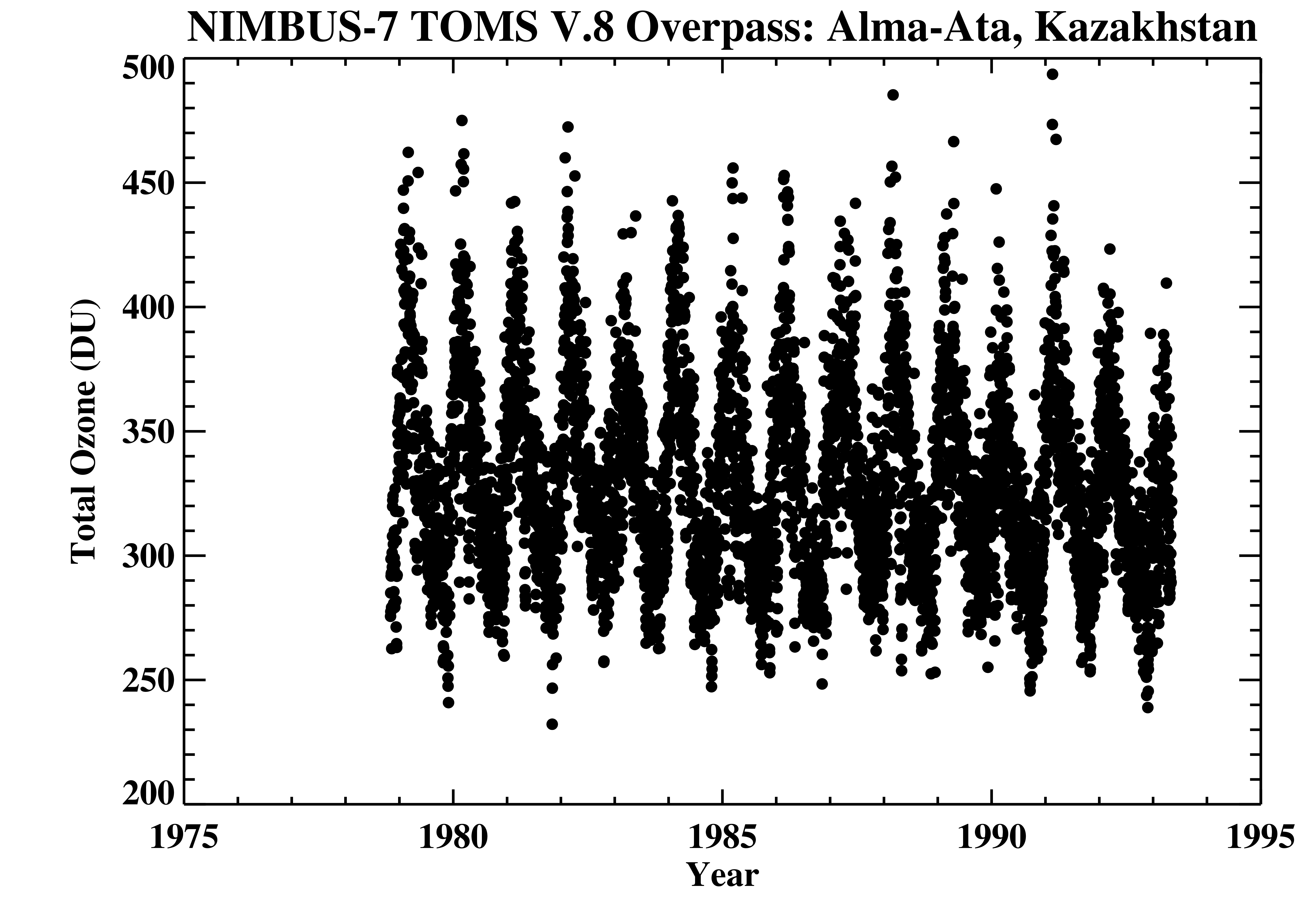
Federal
TOMS Nimbus-7 Ground Station Overpass Data V008 (TOMSN7OVP) at GES DISC
National Aeronautics and Space Administration —
The Nimbus-7 Total Ozone Mapping Spectrometer (TOMS) version 8 daily ground station overpass data product contains total column ozone, UV aerosol index, Lambertian... -
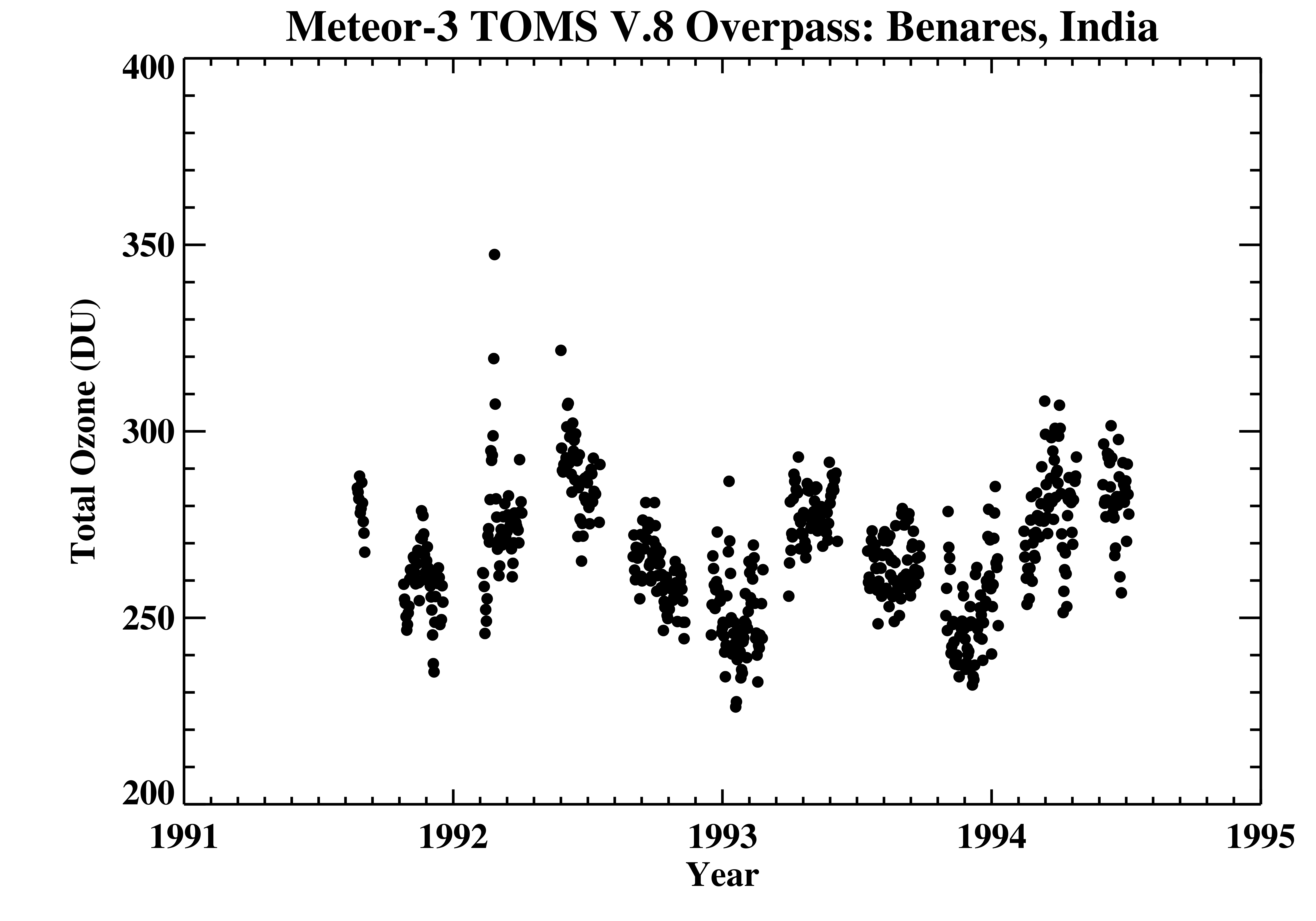
Federal
TOMS Meteor-3 Ground Station Overpass Data V008 (TOMSM3OVP) at GES DISC
National Aeronautics and Space Administration —
The Meteor-3 Total Ozone Mapping Spectrometer (TOMS) version 8 daily ground station overpass data product contains total column ozone, UV aerosol index, Lambertian... -
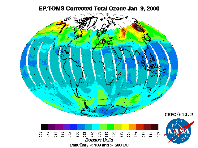
Federal
TOMS Earth-Probe Total Ozone (O3) Aerosol Index UV-Reflectivity UV-B Erythemal Irradiances Daily L3 Global 1 deg x 1.25 deg V008 (TOMSEPL3) at GES DISC
National Aeronautics and Space Administration —
The Earth Probe (EP) Total Ozone Mapping Spectrometer (TOMS) version 8 daily global gridded data product contains total column ozone, UV aerosol index, Lambertian...

Official websites use .gov
A
.gov website belongs to an official government
organization in the United States.
Secure .gov websites use HTTPS
A
lock (
) or https:// means you’ve safely connected to
the .gov website. Share sensitive information only on official,
secure websites.