
-
Federal
Archive of NOAA Continuously Operating Reference Stations (CORS) Network (NCN)
National Oceanic and Atmospheric Administration, Department of Commerce —
The National Geodetic Survey's (NGS) NOAA Continuously Operating Reference Stations (CORS) Network (NCN) provides Global Navigation Satellite System (GNSS) data... -
Federal
Multibeam collection for RP15SU83: Multibeam data collected aboard Surveyor from 05-May-83 to 03-Sep-83, None to None
National Oceanic and Atmospheric Administration, Department of Commerce —
This data set is part of a larger set of data called the Multibeam Bathymetry Database (MBBDB) where other similar data can be found -
Federal
F00929: NOS Hydrographic Survey , 2026-01-22
National Oceanic and Atmospheric Administration, Department of Commerce —
The National Oceanic and Atmospheric Administration (NOAA) has the statutory mandate to collect hydrographic data in support of nautical chart compilation for safe... -
Federal
Multibeam collection for MV1309: Multibeam data collected aboard Melville from 15-Jul-13 to 30-Jul-13, Seattle, Washington to Seattle
National Oceanic and Atmospheric Administration, Department of Commerce —
This data set is part of a larger set of data called the Multibeam Bathymetry Database (MBBDB) where other similar data can be found -
Federal
Multibeam collection for OXMZ01MV: Multibeam data collected aboard Melville from 29-Oct-99 to 22-Nov-99, San Diego, California to San Diego, California
National Oceanic and Atmospheric Administration, Department of Commerce —
This data set is part of a larger set of data called the Multibeam Bathymetry Database (MBBDB) where other similar data can be found -
Federal
Multibeam collection for KN147L2: Multibeam data collected aboard Knorr from 02-Nov-96 to 04-Dec-96, Ponta Delgada, Azores to Southampton, England
National Oceanic and Atmospheric Administration, Department of Commerce —
This data set is part of a larger set of data called the Multibeam Bathymetry Database (MBBDB) where other similar data can be found -
Federal
H13979: NOS Hydrographic Survey , 2025-01-25
National Oceanic and Atmospheric Administration, Department of Commerce —
The National Oceanic and Atmospheric Administration (NOAA) has the statutory mandate to collect hydrographic data in support of nautical chart compilation for safe... -
Federal
GOES-R SERIES Advanced Baseline Imager (ABI) Instrument Calibration Data
National Oceanic and Atmospheric Administration, Department of Commerce —
The ABI Instrument Engineering Telemetry Data file contains data used to support the generation of ABI Level 1b products, and monitor and evaluate the health and... -
Federal
F00443: NOS Hydrographic Survey , Charleston Harbor, South Carolina and Adjoining Waterways, South Carolina, 1998-07-29
National Oceanic and Atmospheric Administration, Department of Commerce —
The National Oceanic and Atmospheric Administration (NOAA) has the statutory mandate to collect hydrographic data in support of nautical chart compilation for safe... -
Federal
F00757: NOS Hydrographic Survey , 2018-11-01
National Oceanic and Atmospheric Administration, Department of Commerce —
The National Oceanic and Atmospheric Administration (NOAA) has the statutory mandate to collect hydrographic data in support of nautical chart compilation for safe... -
Federal
D00239: NOS Hydrographic Survey , 2017-09-15
National Oceanic and Atmospheric Administration, Department of Commerce —
The National Oceanic and Atmospheric Administration (NOAA) has the statutory mandate to collect hydrographic data in support of nautical chart compilation for safe... -
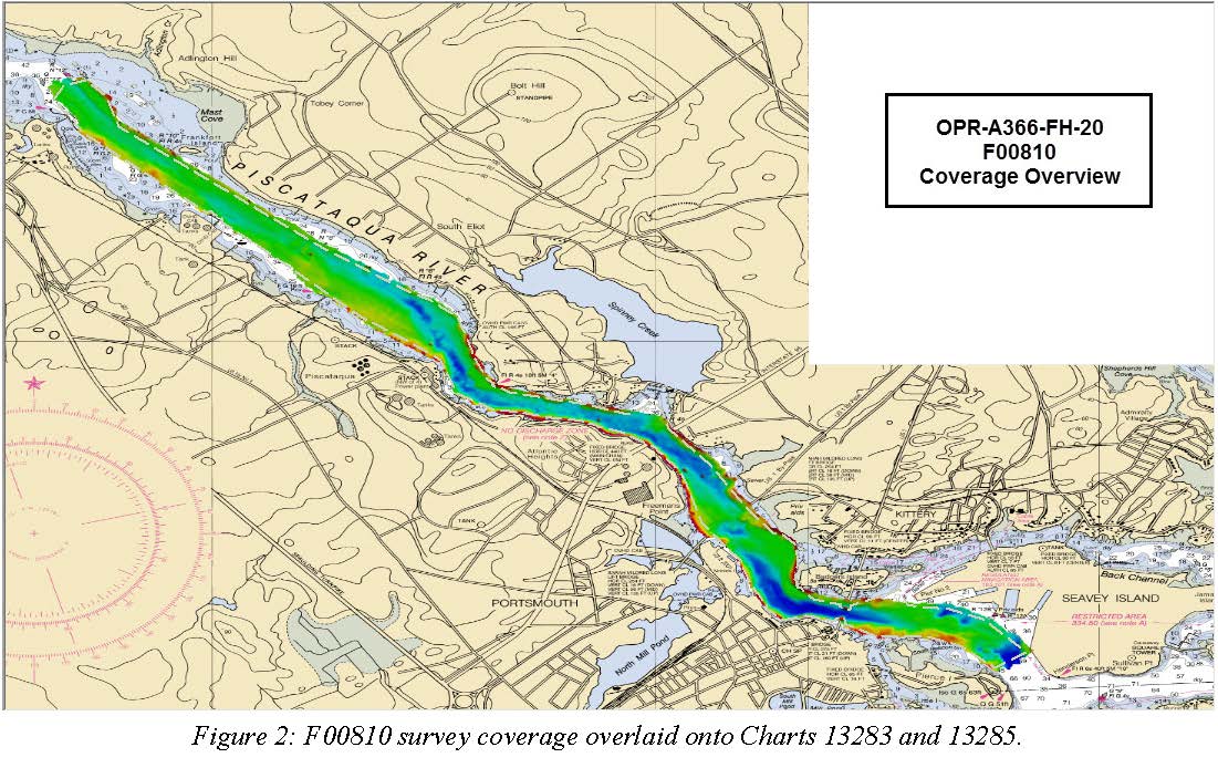
Federal
F00810: NOS Hydrographic Survey , 2020-08-05
National Oceanic and Atmospheric Administration, Department of Commerce —
The National Oceanic and Atmospheric Administration (NOAA) has the statutory mandate to collect hydrographic data in support of nautical chart compilation for safe... -
Federal
Multibeam collection for SKQ201701S: Multibeam data collected aboard Sikuliaq from 19-Jan-17 to 15-Feb-17, Manzanillo, Mexico to San Diego, California
National Oceanic and Atmospheric Administration, Department of Commerce —
This data set is part of a larger set of data called the Multibeam Bathymetry Database (MBBDB) where other similar data can be found -
Federal
Multibeam collection for PD20T401: Multibeam data collected aboard Pressure Drop from 20-Aug-20 to 30-Aug-20, None to Honolulu, Hawaii
National Oceanic and Atmospheric Administration, Department of Commerce —
This data set is part of a larger set of data called the Multibeam Bathymetry Database (MBBDB) where other similar data can be found -
Federal
Multibeam collection for SKQ201507T: Multibeam data collected aboard Sikuliaq from 24-Jun-15 to 07-Jul-15, Seward, Alaska to Dutch Harbor, Alaska
National Oceanic and Atmospheric Administration, Department of Commerce —
This data set is part of a larger set of data called the Multibeam Bathymetry Database (MBBDB) where other similar data can be found -
Federal
Multibeam collection for KM1115: Multibeam data collected aboard Kilo Moana from 26-Apr-11 to 14-May-11, Honolulu, Hawaii to Honolulu, Hawaii
National Oceanic and Atmospheric Administration, Department of Commerce —
This data set is part of a larger set of data called the Multibeam Bathymetry Database (MBBDB) where other similar data can be found -
Federal
D00281: NOS Hydrographic Survey , 2023-07-01
National Oceanic and Atmospheric Administration, Department of Commerce —
The National Oceanic and Atmospheric Administration (NOAA) has the statutory mandate to collect hydrographic data in support of nautical chart compilation for safe... -
Federal
H13977: NOS Hydrographic Survey , 2025-01-25
National Oceanic and Atmospheric Administration, Department of Commerce —
The National Oceanic and Atmospheric Administration (NOAA) has the statutory mandate to collect hydrographic data in support of nautical chart compilation for safe... -
Federal
NOAA/PIBHMC 5-m Bathymetry: CNMI: Saipan
National Oceanic and Atmospheric Administration, Department of Commerce —
A 5-m resolution gridded digital elevation model (DEM) for the bathymetry (ocean depth) surrounding the island of Saipan in the Commonwealth of the Northern Mariana... -
Federal
Integrated Global Radiosonde Archive (IGRA), Version 2
National Oceanic and Atmospheric Administration, Department of Commerce —
Integrated Global Radiosonde Archive (IGRA) Version 2 consists of quality-controlled radiosonde observations of temperature, humidity, and wind at stations across all...

Official websites use .gov
A
.gov website belongs to an official government
organization in the United States.
Secure .gov websites use HTTPS
A
lock (
) or https:// means you’ve safely connected to
the .gov website. Share sensitive information only on official,
secure websites.
.jpg)