
-
Federal
H03218: NOS Hydrographic Survey
National Oceanic and Atmospheric Administration, Department of Commerce —
The National Oceanic and Atmospheric Administration (NOAA) has the statutory mandate to collect hydrographic data in support of nautical chart compilation for safe... -
Federal
Airborne magnetic flight line data, Charleston, South Carolina and surrounds, 2019
Department of the Interior —
Airborne magnetic gradiometry data are provided here as part of the data release, "Airborne magnetic and radiometric survey, Charleston, South Carolina and surrounds,... -
Federal
H03943: NOS Hydrographic Survey
National Oceanic and Atmospheric Administration, Department of Commerce —
The National Oceanic and Atmospheric Administration (NOAA) has the statutory mandate to collect hydrographic data in support of nautical chart compilation for safe... -
Federal
Monthly and annual mean seawater temperature, salinity and density from 26 tide gauge sites during 1855-1993 (NCEI Accession 0000817)
National Oceanic and Atmospheric Administration, Department of Commerce —
Tidal observers at primary tide gauges of the United States Coast and Geodetic Survey (now the NOAA National Ocean Service) routinely measured seawater temperature... -
Federal
H03549B: NOS Hydrographic Survey
National Oceanic and Atmospheric Administration, Department of Commerce —
The National Oceanic and Atmospheric Administration (NOAA) has the statutory mandate to collect hydrographic data in support of nautical chart compilation for safe... -
Federal
F00551: NOS Hydrographic Survey , Charleston Harbor, South Carolina, 2007-02-11
National Oceanic and Atmospheric Administration, Department of Commerce —
The National Oceanic and Atmospheric Administration (NOAA) has the statutory mandate to collect hydrographic data in support of nautical chart compilation for safe... -
Federal
USGS Cruise 97009 Sidescan Sonar Data Files
Department of the Interior —
This CD-ROM contains digital high resolution sidescan sonar data collected during the USGS Cruise 97009 aboard the R/V MS MS Coastal. This CD-ROM (Compact Disc-Read... -
Federal
TIGER/Line Shapefile, Current, County, Charleston County, SC, All Lines
U.S. Census Bureau, Department of Commerce —
The TIGER/Line shapefiles and related database files (.dbf) are an extract of selected geographic and cartographic information from the U.S. Census Bureau's Master... -
Federal
Subbottom Profile Data Collection for EX1202_1: Gulf of Mexico Exploration
National Oceanic and Atmospheric Administration, Department of Commerce —
Profile data files: Subbottom Profiler -
Federal
TIGER/Line Shapefile, 2023, County, Charleston County, SC, Address Ranges Relationship File
U.S. Census Bureau, Department of Commerce —
The TIGER/Line shapefiles and related database files (.dbf) are an extract of selected geographic and cartographic information from the U.S. Census Bureau's Master... -
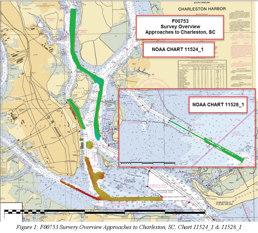
Federal
F00753: NOS Hydrographic Survey , 2018-10-23
National Oceanic and Atmospheric Administration, Department of Commerce —
The National Oceanic and Atmospheric Administration (NOAA) has the statutory mandate to collect hydrographic data in support of nautical chart compilation for safe... -
Federal
TIGER/Line Shapefile, 2022, County, Charleston County, SC, Address Range-Feature
U.S. Census Bureau, Department of Commerce —
The TIGER/Line shapefiles and related database files (.dbf) are an extract of selected geographic and cartographic information from the U.S. Census Bureau's Master... -
Federal
TIGER/Line Shapefile, 2024, County, Charleston County, SC, Feature Names Relationship File
U.S. Census Bureau, Department of Commerce —
The TIGER/Line shapefiles and related database files (.dbf) are an extract of selected geographic and cartographic information from the U.S. Census Bureau's Master... -
Federal
TIGER/Line Shapefile, 2022, County, Charleston County, SC, Topological Faces (Polygons With All Geocodes)
U.S. Census Bureau, Department of Commerce —
The TIGER/Line shapefiles and related database files (.dbf) are an extract of selected geographic and cartographic information from the U.S. Census Bureau's Master... -
Federal
TIGER/Line Shapefile, 2022, County, Charleston County, SC, Topological Faces-Area Hydrography Relationship File
U.S. Census Bureau, Department of Commerce —
The TIGER/Line shapefiles and related database files (.dbf) are an extract of selected geographic and cartographic information from the U.S. Census Bureau's Master... -
Federal
USGS Cruise 95009 Sidescan Sonar Data Files
Department of the Interior —
SIDESCAN SONAR AND NAVIGATION FIELD DATA COLLECTED DURING MS MS Coastal 95009 (1 - 14 August, 1995). This CD-ROM (Compact Disc-Read Only Memory) has been produced in... -
Federal
H11863: NOS Hydrographic Survey , Charleston Harbor, South Carolina, 2009-09-02
National Oceanic and Atmospheric Administration, Department of Commerce —
The National Oceanic and Atmospheric Administration (NOAA) has the statutory mandate to collect hydrographic data in support of nautical chart compilation for safe... -
Federal
TIGER/Line Shapefile, Current, County, Charleston County, SC, Address Range-Feature Name Relationship File
U.S. Census Bureau, Department of Commerce —
The TIGER/Line shapefiles and related database files (.dbf) are an extract of selected geographic and cartographic information from the U.S. Census Bureau's Master... -
Federal
TIGER/Line Shapefile, 2022, County, Charleston County, SC, Feature Names Relationship File
U.S. Census Bureau, Department of Commerce —
The TIGER/Line shapefiles and related database files (.dbf) are an extract of selected geographic and cartographic information from the U.S. Census Bureau's Master... -
Federal
H04906: NOS Hydrographic Survey
National Oceanic and Atmospheric Administration, Department of Commerce —
The National Oceanic and Atmospheric Administration (NOAA) has the statutory mandate to collect hydrographic data in support of nautical chart compilation for safe...

Official websites use .gov
A
.gov website belongs to an official government
organization in the United States.
Secure .gov websites use HTTPS
A
lock (
) or https:// means you’ve safely connected to
the .gov website. Share sensitive information only on official,
secure websites.
.jpg)
.jpg)