
-
Federal
EnviroAtlas - Baltimore, MD - 15m Riparian Buffer Vegetated Cover
U.S. Environmental Protection Agency —
This EnviroAtlas dataset describes the percentage of a 15-m riparian buffer that is vegetated. In this community, vegetated land is defined as Trees & Forest,... -
Federal
EnviroAtlas Estimated Percent Tree Cover Along Walkable Roads Web Service
U.S. Environmental Protection Agency —
This EnviroAtlas dataset estimates tree cover along walkable roads. The road width is estimated for each road and percent tree cover is calculated in a 8.5 meter... -
City
Subsidized Housing - Six Metro Areas - 2017
City of Ferndale, Michigan —
Subsidized Housing Unit data was downloaded from the National Housing Preservation Database for Atlanta, Baltimore, Detroit, New Orleans, Pittsburgh, and Oakland, CA... -
Federal
Embedded Fragments Registry (EFR)
Department of Veterans Affairs —
In 2009, the Department of Defense estimated that approximately 40,000 service members who served in OEF/OIF may have embedded fragment wounds as the result of small... -
Federal
EnviroAtlas - Baltimore, MD - Residents with Potential Window Views of Water by Block Group
U.S. Environmental Protection Agency —
This EnviroAtlas dataset describes the block group population and the percentage of the block group population that has potential views of water bodies. A potential... -
Federal
TIGER/Line Shapefile, 2023, County, Baltimore County, MD, Topological Faces-Area Hydrography Relationship File
U.S. Census Bureau, Department of Commerce —
The TIGER/Line shapefiles and related database files (.dbf) are an extract of selected geographic and cartographic information from the U.S. Census Bureau's Master... -
Federal
F00656: NOS Hydrographic Survey , 2015-04-02
National Oceanic and Atmospheric Administration, Department of Commerce —
The National Oceanic and Atmospheric Administration (NOAA) has the statutory mandate to collect hydrographic data in support of nautical chart compilation for safe... -
Federal
TIGER/Line Shapefile, 2022, County, Baltimore city, MD, All Lines
U.S. Census Bureau, Department of Commerce —
The TIGER/Line shapefiles and related database files (.dbf) are an extract of selected geographic and cartographic information from the U.S. Census Bureau's Master... -
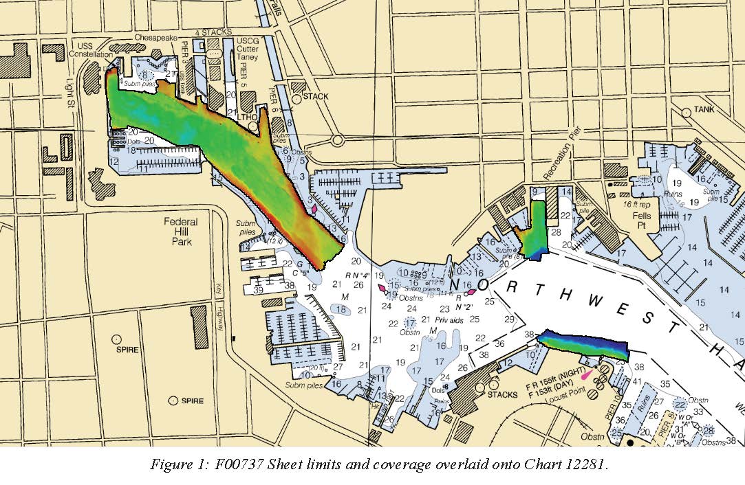
Federal
F00737: NOS Hydrographic Survey , 2018-08-08
National Oceanic and Atmospheric Administration, Department of Commerce —
The National Oceanic and Atmospheric Administration (NOAA) has the statutory mandate to collect hydrographic data in support of nautical chart compilation for safe... -
Federal
W00738: NOS Hydrographic Survey , External Source Data 2024, 2014-07-16
National Oceanic and Atmospheric Administration, Department of Commerce —
The National Oceanic and Atmospheric Administration (NOAA) has the statutory mandate to collect hydrographic data in support of nautical chart compilation for safe... -
Federal
EnviroAtlas 15m Riparian Buffer Vegetated Cover Web Service
U.S. Environmental Protection Agency —
This EnviroAtlas web service supports research and online mapping activities related to EnviroAtlas (https://www.epa.gov/enviroatlas). This EnviroAtlas dataset... -
Federal
TIGER/Line Shapefile, 2023, County, Baltimore County, MD, Topological Faces (Polygons With All Geocodes)
U.S. Census Bureau, Department of Commerce —
The TIGER/Line shapefiles and related database files (.dbf) are an extract of selected geographic and cartographic information from the U.S. Census Bureau's Master... -
Federal
TIGER/Line Shapefile, Current, County, Baltimore County, MD, Address Range-Feature
U.S. Census Bureau, Department of Commerce —
The TIGER/Line shapefiles and related database files (.dbf) are an extract of selected geographic and cartographic information from the U.S. Census Bureau's Master... -
State
Choose Maryland: Compare Metros - Demographics
State of Maryland —
Population and income profile - totals, median household. -
Federal
EnviroAtlas - Baltimore, MD - Historic Places by Census Block Group
U.S. Environmental Protection Agency —
This EnviroAtlas dataset portrays the total number of historic places located within each Census Block Group (CBG). The historic places data were compiled from the... -
Federal
TIGER/Line Shapefile, Current, County, Baltimore city, MD, Area Hydrography
U.S. Census Bureau, Department of Commerce —
The TIGER/Line shapefiles and related database files (.dbf) are an extract of selected geographic and cartographic information from the U.S. Census Bureau's Master... -
Federal
Visible and near-infrared spectroscopy for sediment samples collected across North-eastern U.S.
Department of the Interior —
This data record contains a CSV file with spectral reflectance (420-2114 nm) for sediment samples collected from each of four source locations (cropland, stream bank,... -
Federal
EnviroAtlas - Baltimore, MD - Estimated Tree Cover Along Busy Roads
U.S. Environmental Protection Agency —
'This EnviroAtlas dataset addresses the tree buffer along heavily traveled roads. The roads are interstates, arterials, and collectors within the EnviroAtlas... -
Federal
TIGER/Line Shapefile, 2023, County, Baltimore County, MD, Address Ranges Relationship File
U.S. Census Bureau, Department of Commerce —
The TIGER/Line shapefiles and related database files (.dbf) are an extract of selected geographic and cartographic information from the U.S. Census Bureau's Master... -
Federal
The database for the isopach map of the Brightseat Formation and structure contour map of the Cretaceous-Paleogene boundary, in Maryland and Virginia
Department of the Interior —
The goal of the Atlantic Subsurface Stratigraphic Initiative (ASSI) is to create isopach and structural contour maps for all Coastal Plain formations within the...

Official websites use .gov
A
.gov website belongs to an official government
organization in the United States.
Secure .gov websites use HTTPS
A
lock (
) or https:// means you’ve safely connected to
the .gov website. Share sensitive information only on official,
secure websites.