
-
Federal
TOLNet NASA Langley Research Center Data
National Aeronautics and Space Administration —
TOLNet_LaRC_Data is the lidar data collected by the Langley Mobile Ozone Lidar (LMOL) at NASA Langley Research Center (LaRC) as part of the Tropospheric Ozone Lidar... -
Federal
UARS Wind Imaging Interferometer (WINDII) Level 3AL V011 (UARWI3AL) at GES DISC
National Aeronautics and Space Administration —
The Wind Imaging Interferometer (WINDII) Level 3AL data product consists of daily, 4 degree increment latitude-ordered vertical profiles of meridional and zonal wind... -
Federal
ATTREX-Aircraft_navigational_and_meteorological_Measurements
National Aeronautics and Space Administration —
ATTREX-Aircraft_navigational_meteorological_Measurements are in-situ navigational and meteorological measurements collected onboard the Global Hawk Unihabited Aerial... -
Federal
SWOT Level 2 Radiometer Brightness Temperatures and Troposphere Interim Data Product, Version 2.0
National Aeronautics and Space Administration —
The SWOT Level 2 Radiometer Brightness Temperatures and Troposphere Interim Geophysical Data Record (IGDR) Version 1.0 dataset produced by the Surface Water and Ocean... -
Federal
GPM Ground Validation Duke Microwave Radiometer (MWR) IPHEx V1
National Aeronautics and Space Administration —
The GPM Ground Validation Duke Microwave Radiometer (MWR) IPHEx dataset consists of data collected by the MWR, which is a sensitive microwave radiometer that detects... -
Federal
SnowEx Meteorological Station Measurements from Grand Mesa, CO Raw V001
National Aeronautics and Space Administration —
This dataset contains raw meteorological data collected as part of the ongoing the NASA SnowEx mission, from five meteorological stations installed between 2016-2017... -
Federal
High Mountain Asia COAWST 6-Hourly 4km Regional Climate Model Simulations V001
National Aeronautics and Space Administration —
This data product contains either 6-hourly accumulated or 6-hourly snapshots of modeled data in the High Mountain Asia region, generated by the Coupled-Ocean-... -
Federal
GPM GROUND VALIDATION DC-8 NAVIGATION AND HOUSEKEEPING DATA GCPEX V1
National Aeronautics and Space Administration —
The GPM Ground Validation DC-8 Navigation and Housekeeping Data GCPEx dataset, which is composed of two types of files. GCPEx addressed shortcomings in the GPM... -
Federal
UARS Correlative NMC Daily Gridded Stratospheric Assimilated Data V001 (UARZCNMC) at GES DISC
National Aeronautics and Space Administration —
The UARS Correlative assimilation data from NOAA's National Meteorological Center (NMC) consists of daily model runs at 12 GMT as a means of providing an independent... -
Federal
SnowEx21 Prairie Station Hourly Meteorological Data V001
National Aeronautics and Space Administration —
This data set contains observations from a meteorological station installed at the Central Agricultural Research Center in Moccasin Montana as part of the NASA SnowEx... -
Federal
Automated Surface Observing System (ASOS) IMPACTS V1
National Aeronautics and Space Administration —
The Automated Surface Observing Systems (ASOS) IMPACTS dataset consists of a variety of ground-based observations during the Investigation of Microphysics and... -
Federal
CERES Clouds and Radiative Swath Aqua FM3 MODIS Edition2C
National Aeronautics and Space Administration —
CER_CRS_Aqua-FM3-MODIS_Edition2c is the Clouds and the Earth's Radiant Energy System (CERES) Clouds and Radiative Swath (CRS) Aqua-Flight Model 3 (FM3) Moderate-... -
Federal
GPM GROUND VALIDATION OKLAHOMA CLIMATOLOGICAL SURVEY MESONET MC3E V1
National Aeronautics and Space Administration —
The GPM Ground Validation Oklahoma Climatological Survey Mesonet MC3E data were collected during the Midlatitude Continental Convective Clouds Experiment (MC3E) in... -
Federal
GPM Ground Validation NASA ER-2 Navigation Data IPHEx V1
National Aeronautics and Space Administration —
The GPM Ground Validation NASA ER-2 Navigation Data IPHEx dataset was gathered during the GPM Ground Validation Integrated Precipitation and Hydrology Experiment... -
Federal
High Mountain Asia Langtang Automatic Weather Station Measurements V001
National Aeronautics and Space Administration —
This data set contains meteorological data, such as air temperature, pressure, rainfall intensity, relative humidity, and wind direction/speed measured by the... -
Federal
UARS Wind Imaging Interferometer (WINDII) Level 3AT V011 (UARWI3AT) at GES DISC
National Aeronautics and Space Administration —
The Wind Imaging Interferometer (WINDII) Level 3AT data product consists of daily, 65.536 second interval time-ordered vertical profiles of meridional and zonal wind... -
Federal
SnowEx Meteorological Station Measurements from Grand Mesa, CO V001
National Aeronautics and Space Administration —
This dataset contains meteorological data collected as part of the ongoing the NASA SnowEx mission, from five meteorological stations installed between 2016-2017 in... -
Federal
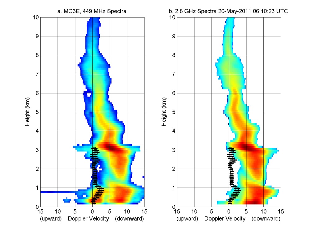
GPM GROUND VALIDATION NOAA UHF 449 PROFILER MC3E V1
National Aeronautics and Space Administration —
The GPM Ground Validation NOAA UHF 449 Profiler MC3E dataset was collected during the NASA supported Midlatitude Continental Convective Clouds Experiment (MC3E). The... -
Federal
New York State Mesonet IMPACTS V1
National Aeronautics and Space Administration —
The New York State Mesonet IMPACTS dataset is a browse-only dataset and consists of temperature, wind, wind direction, mean sea level pressure, precipitation, and...

Official websites use .gov
A
.gov website belongs to an official government
organization in the United States.
Secure .gov websites use HTTPS
A
lock (
) or https:// means you’ve safely connected to
the .gov website. Share sensitive information only on official,
secure websites.