

94 datasets found
-
State
Southern Dishna River electromagnetic and magnetic airborne geophysical survey data compilation
State of Alaska —
The Southern Dishna River survey is one of several geophysical surveys, collectively known as the Five Spot project (Southern Dishna River, Beaver Creek, and Fox... -
Federal
LiDAR as an Exploration Tool
Department of Energy —
Using LiDAR to identify structural and volcanic evolution of a Miocene-Pleistocene age bimodal volcanic complex and implications for geothermal potential. The file... -
State
Ketchikan electromagnetic and magnetic airborne geophysical survey data compilation
State of Alaska —
The Ketchikan geophysical survey is located in southeast Alaska in the Ketchikan area, about 350 kilometers south of Juneau, Alaska. Frequency domain electromagnetic... -
State
East Styx electromagnetic, magnetic, and radiometric airborne geophysical survey data compilation
State of Alaska —
The East Styx electromagnetic, magnetic, and radiometric airborne geophysical survey is located about 150 kilometers northwest of Anchorage, Alaska in the upper... -
State
Southern Delta River electromagnetic and magnetic airborne geophysical survey data compilation
State of Alaska —
The Southern Delta River electromagnetic and magnetic airborne geophysical survey is located in interior Alaska in the Delta River mining district, about 200... -
Federal
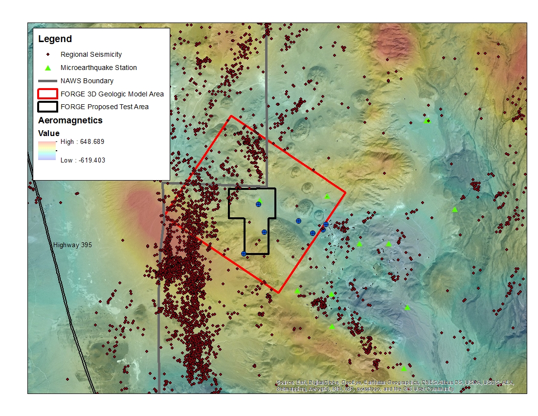
West Flank Coso, CA FORGE Test Area
Department of Energy —
A map with the Coso West Flank FORGE test area outlined, along with regional seismicity, the aeromagnetic data set and the area currently being utilized for the... -
State
Liscum electromagnetic and magnetic airborne geophysical survey data compilation
State of Alaska —
The Liscum electromagnetic and magnetic airborne geophysical survey is located in interior Alaska in the Goodpaster mining district, about 120 kilometers southeast of... -
State
White Mountains airborne magnetic and radiometric geophysical survey
State of Alaska —
White Mountains airborne magnetic and radiometric geophysical survey, Geophysical Report 2021-3 v. 2, covers parts of Livengood, Circle, and Fairbanks quadrangles 25... -
State
Nikolai electromagnetic and magnetic airborne geophysical survey data compilation
State of Alaska —
The Nikolai electromagnetic and magnetic airborne geophysical survey is located in interior Alaska in the Delta River mining district, about 200 kilometers southeast... -
State
Alaska Highway corridor electromagnetic and magnetic airborne geophysical survey data compilation
State of Alaska —
The Alaska Highway corridor electromagnetic and magnetic airborne geophysical survey is located in interior Alaska along the Alaska Highway corridor, from Delta... -
State
Electromagnetic and magnetic airborne-geophysical survey of the Liberty Bell area, western Bonnifield mining district, Alaska (data compilation)
State of Alaska —
The Liberty Bell geophysical survey was originally flown in 2001 and published in 2002 (Alaska Division of Geological & Geophysical Surveys and others, 2002) as a... -
Federal
Geothermal Data Gap Analysis Over the Western US
Department of Energy —
NREL, as part of the Play Fairway Analysis Retrospective, compiled and mapped publicly available geologic and geophysical data in relation to the 2008 USGS geothermal... -
Federal
Airborne Magnetic Geophysical Survey of the Porcupine River Area, Alaska
Department of the Interior —
The Porcupine River fixed wing aeromagnetic geophysical survey is located in eastern Alaska, along the Canadian border, in the Sheenjek and Black mining districts.... -
Federal
Kuskokwim Airborne Magnetic and Radiometric Survey, Sischu Mountains
Department of the Interior —
Kuskokwim airborne magnetic and radiometric survey, Sischu Mountains, Geophysical Report 2024-1, covers parts of the Ruby, Kantishna River, Mt. McKinley, Medfra, and... -
State
Airborne magnetic geophysical survey of the lower Yukon Delta, Alaska, data compilation
State of Alaska —
This airborne magnetic geophysical survey of the lower Yukon Delta, Alaska is in the St Michael, Kwiguk, and Black 1:250,000-scale USGS quadrangles on the Yukon River... -
Federal
Kuskokwim Airborne Magnetic and Radiometric Geophysical Survey, Northern Kuskokwim Mountains
Department of the Interior —
Kuskokwim airborne magnetic and radiometric geophysical survey, northern Kuskokwim Mountains, Geophysical Report 2023-1, covers parts of the Tanana, Norton Bay,... -
State
Fairbanks electromagnetic and magnetic airborne geophysical survey data compilation
State of Alaska —
The Fairbanks electromagnetic and magnetic airborne geophysical survey is located in interior Alaska in the Fairbanks mining district, which includes the city of... -
State
Eagle airborne magnetic and radiometric geophysical survey
State of Alaska —
The Eagle airborne magnetic and radiometric geophysical survey covers parts of the Charley River, Eagle, and Tanacross quadrangles near Eagle, Alaska (fig. 1).... -
State
Farewell electromagnetic, magnetic, and radiometric airborne geophysical survey data compilation
State of Alaska —
The Farewell geophysical survey is located in the Alaska Range of southcentral Alaska in the Yentna and McGrath mining districts, about 150 kilometers northwest of... -
State
Headwaters of the Little Chena River electromagnetic and magnetic airborne geophysical survey data compilation
State of Alaska —
The Headwaters of the Little Chena River electromagnetic and magnetic airborne geophysical survey is located in interior Alaska in the Fairbanks mining district,...
94 datasets found