
-
Federal
NOAA/WDS Paleoclimatology - Kyoto, Japan 1,200 Year Cherry Tree Flowering Dates and March Temperature Reconstructions
National Oceanic and Atmospheric Administration, Department of Commerce —
This archived Paleoclimatology Study is available from the NOAA National Centers for Environmental Information (NCEI), under the World Data Service (WDS) for... -
Federal
Reefs for the future: Resilience of coral reefs in the main Hawaiian Islands
National Oceanic and Atmospheric Administration, Department of Commerce —
Declining health of coral reef ecosystems led scientists to search for factors that support reef resilience: the ability of reefs to resist and recover from... -
Federal
Washington Volcanic Ash Advisory Center Volcanic Ash Advisories and Volcanic Ash Graphics from 2007 to 2025
National Oceanic and Atmospheric Administration, Department of Commerce —
The Washington Volcanic Ash Advisory Center is a 365/24/7 operational group that is part of the NOAA/National Environmental Satellite, Data, and Information Service... -
Federal
Digital Elevation Model of the Gulf of Mexico, Integrating Bathymetric and Topographic Datasets
National Oceanic and Atmospheric Administration, Department of Commerce —
Modeling and mapping of coastal processes (e.g. tsunamis, hurricane storm-surge, and sea-level rise) requires digital representations of Earth's solid surface,... -
Federal
Solar Indices - Solar Radio Flux
National Oceanic and Atmospheric Administration, Department of Commerce —
Collection includes a variety of indices related to solar activity contributed by a number of national and private solar observatories located worldwide. This... -
Federal
NOAA/WDS Paleoclimatology - Northern Hemisphere 1000 Year Multiproxy Temperature Reconstruction
National Oceanic and Atmospheric Administration, Department of Commerce —
This archived Paleoclimatology Study is available from the NOAA National Centers for Environmental Information (NCEI), under the World Data Service (WDS) for... -
Federal
NOAA/WDS Paleoclimatology - Globally Resolved Surface Temperatures Since the Last Glacial Maximum
National Oceanic and Atmospheric Administration, Department of Commerce —
This archived Paleoclimatology Study is available from the NOAA National Centers for Environmental Information (NCEI), under the World Data Service (WDS) for... -
Federal
Hurricane Hugo Poster (September 21, 1989)
National Oceanic and Atmospheric Administration, Department of Commerce —
Hurricane Hugo poster. Multi-spectral image from NOAA-11 captures Hurricane Hugo slamming into South Carolina coast on September 21, 1989. Poster size is 36"x36". -
Federal
F00757: NOS Hydrographic Survey , 2018-11-01
National Oceanic and Atmospheric Administration, Department of Commerce —
The National Oceanic and Atmospheric Administration (NOAA) has the statutory mandate to collect hydrographic data in support of nautical chart compilation for safe... -
Federal
Kawaihae, Hawaii Tsunami Forecast Grids for MOST Model
National Oceanic and Atmospheric Administration, Department of Commerce —
The Kawaihae, Hawaii Forecast Model Grids provides bathymetric data strictly for tsunami inundation modeling with the Method of Splitting Tsunami (MOST) model. MOST... -
Federal
D00239: NOS Hydrographic Survey , 2017-09-15
National Oceanic and Atmospheric Administration, Department of Commerce —
The National Oceanic and Atmospheric Administration (NOAA) has the statutory mandate to collect hydrographic data in support of nautical chart compilation for safe... -
Federal
2016 NOAA NGS Ortho-rectified Near-Infrared Mosaic of Muskegon, Grand Haven,and Holland, Michigan
National Oceanic and Atmospheric Administration, Department of Commerce —
This data set contains ortho-rectified mosaic tiles, created as a product from the NOAA Integrated Ocean and Coastal Mapping (IOCM) initiative. The source imagery was... -
Federal
Continuously Updated Digital Elevation Model (CUDEM) - 1/3 Arc-Second Resolution Bathymetric-Topographic Tiles NGDA
National Oceanic and Atmospheric Administration, Department of Commerce —
NOAA's National Centers for Environmental Information (NCEI) is developing a suite of digital elevation models (DEMs) for the U.S. coast to support a variety of NOAA... -
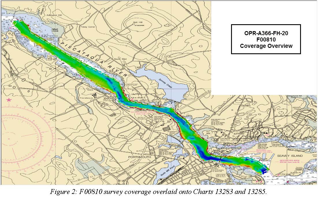
Federal
F00810: NOS Hydrographic Survey , 2020-08-05
National Oceanic and Atmospheric Administration, Department of Commerce —
The National Oceanic and Atmospheric Administration (NOAA) has the statutory mandate to collect hydrographic data in support of nautical chart compilation for safe... -
Federal
Coastal Mapping Program of Port of Everett, WA, WA2503-CS-N NGDA
National Oceanic and Atmospheric Administration, Department of Commerce —
These data provide an accurate high-resolution shoreline compiled from imagery of Port of Everett, WA . This vector shoreline data is based on an office... -
Federal
2025 SCDVA Lidar: Charleston County, SC
National Oceanic and Atmospheric Administration, Department of Commerce —
BERKELEY, CHARLESTON, ORANGEBURG LIDAR DATA COLLECTION Lidar Data Acquisition and Processing Production Task - Charleston County Contract Number: 6004 RFQ Number:... -
Federal
NOAA/WDS Paleoclimatology - Holmes - Frederick Butte - JUOC - OR015, PAGES North America 2K Version
National Oceanic and Atmospheric Administration, Department of Commerce —
This archived Paleoclimatology Study is available from the NOAA National Centers for Environmental Information (NCEI), under the World Data Service (WDS) for... -
Federal
Mount Pinatubo Revisited; A Study of Lahar Erosion
National Oceanic and Atmospheric Administration, Department of Commerce —
At dawn on June 15, 1991, a cataclysmic eruption began with a tremendous explosion that destroyed ten deserted villages. This eruption deposited approximately 5 to 7...

Official websites use .gov
A
.gov website belongs to an official government
organization in the United States.
Secure .gov websites use HTTPS
A
lock (
) or https:// means you’ve safely connected to
the .gov website. Share sensitive information only on official,
secure websites.