
-
Federal
TIGER/Line Shapefile, 2023, County, Washington County, NY, Linear Hydrography
U.S. Census Bureau, Department of Commerce —
The TIGER/Line shapefiles and related database files (.dbf) are an extract of selected geographic and cartographic information from the U.S. Census Bureau's Master... -
Federal
Current linear fuel breaks in the sagebrush biome of the western United States (2020) attributed with relevant environmental variables
Department of the Interior —
Unprecedented wildfire frequency fueled by invasive annual grasses threatens sagebrush habitats. To suppress fire and conserve sagebrush, land management agencies... -
Federal
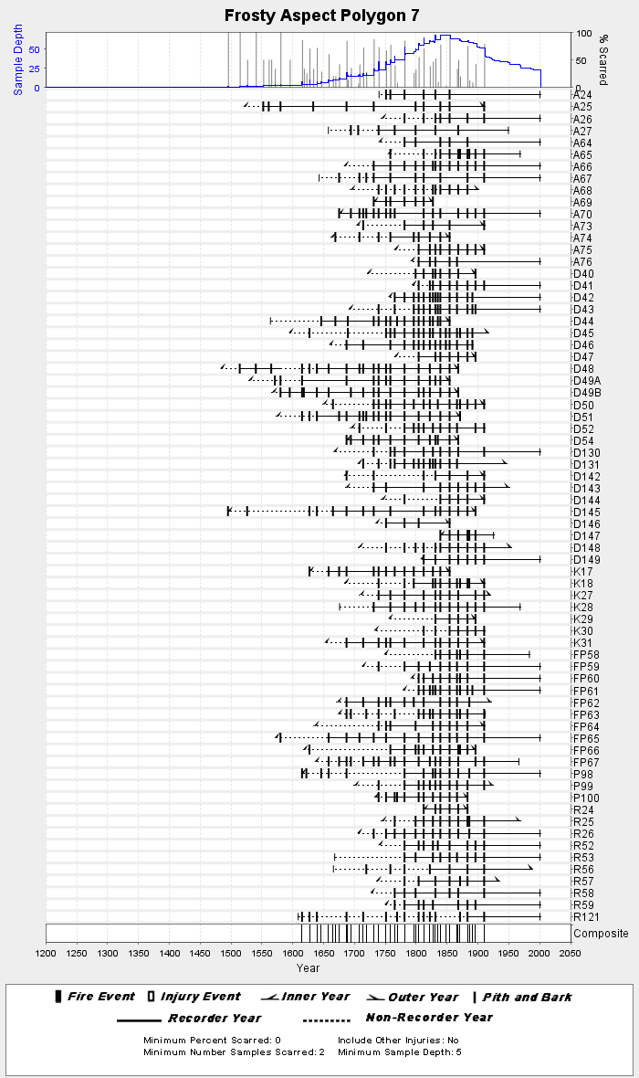
NOAA/WDS Paleoclimatology - Everett fire data from Frosty Aspect Polygon 7 - IMPD USFRS007
National Oceanic and Atmospheric Administration, Department of Commerce —
This archived Paleoclimatology Study is available from the NOAA National Centers for Environmental Information (NCEI), under the World Data Service (WDS) for... -
Federal
EnviroAtlas - Commute Modes and Working from Home by Block Group for the Conterminous United States
U.S. Environmental Protection Agency —
This EnviroAtlas dataset portrays the percent of workers who commute to work using various modes, and the percent who work from home within each Census Block Group... -
Federal
TIGER/Line Shapefile, 2021, County, Columbia County, WA, All Roads
U.S. Census Bureau, Department of Commerce —
The TIGER/Line shapefiles and related database files (.dbf) are an extract of selected geographic and cartographic information from the U.S. Census Bureau's Master... -
Federal
BLM OR Aerial Photography Flightlines Line Hub
Department of the Interior —
AP_FLIGHT_LINE: Line data depicting aerial photography flight lines over BLM lands in Oregon and Washington. -
Federal
C-CAP Land Cover, New Orleans Area Parishes, Louisiana, 2017
National Oceanic and Atmospheric Administration, Department of Commerce —
The NOAA Coastal Change Analysis Program (C-CAP) produces national standardized land cover and change products for the coastal regions of the U.S. C-CAP products... -
Federal
Washington Mule Deer Wenatchee Mountains Winter Range
Department of the Interior —
Along the eastern slope of the Cascade Mountains in Chelan and Kittitas counties, the Wenatchee Mountains mule deer herd inhabits a matrix of private and public... -
Federal
Lakes within the North Cascades National Park Service Complex and surrounding areas, nlakesg1.shp
Department of the Interior —
ArcGIS shapefile of lake polygons. This data set shows where lakes are located within the North Cascades National Park Service Complex and vicinity. -
Federal
TIGER/Line Shapefile, Current, County, Washington County, KY, Address Range-Feature Name Relationship File
U.S. Census Bureau, Department of Commerce —
The TIGER/Line shapefiles and related database files (.dbf) are an extract of selected geographic and cartographic information from the U.S. Census Bureau's Master... -
Federal
BLM OR Forest Operations Inventory Vegetation Publication Hub
Department of the Interior —
FOIVEG_PUB_POLY: Forest Operations Vegetation Inventory Polygon feature class is a forest centric classification of vegetation with polygons that cover 100 % of... -
Federal
TIGER/Line Shapefile, 2023, County, Washington County, VA, All Lines
U.S. Census Bureau, Department of Commerce —
The TIGER/Line shapefiles and related database files (.dbf) are an extract of selected geographic and cartographic information from the U.S. Census Bureau's Master... -
Federal
TIGER/Line Shapefile, 2020, County, Washington County, MS, Topological Faces (Polygons With All Geocodes)
U.S. Census Bureau, Department of Commerce —
The TIGER/Line shapefiles and related database files (.dbf) are an extract of selected geographic and cartographic information from the U.S. Census Bureau's Master... -
Federal
Shoreline Mapping Program of STRAWBERRY POINT, WA, WA1101B NGDA
National Oceanic and Atmospheric Administration, Department of Commerce —
These data provide an accurate high-resolution shoreline compiled from imagery of STRAWBERRY POINT, WA . This vector shoreline data is based on an office... -
Federal
Shoreline Data Rescue Project of Whidbey Island, WA, WA1940B NGDA
National Oceanic and Atmospheric Administration, Department of Commerce —
These data were automated to provide an accurate high-resolution historical shoreline of Whidbey Island, WA suitable as a geographic information system (GIS) data... -
City
Average Maximum Afternoon Temperature (F)
City of Seattle —
This data layer references data from a high-resolution tree canopy change-detection layer for Seattle, Washington. Tree canopy change was mapped by using remotely... -
Federal
TIGER/Line Shapefile, 2022, County, Washington County, OK, Area Hydrography
U.S. Census Bureau, Department of Commerce —
The TIGER/Line shapefiles and related database files (.dbf) are an extract of selected geographic and cartographic information from the U.S. Census Bureau's Master... -
Federal
TIGER/Line Shapefile, 2024, County, Washington County, MO, Address Ranges Relationship File
U.S. Census Bureau, Department of Commerce —
The TIGER/Line shapefiles and related database files (.dbf) are an extract of selected geographic and cartographic information from the U.S. Census Bureau's Master... -
Federal
H04743B: NOS Hydrographic Survey
National Oceanic and Atmospheric Administration, Department of Commerce —
The National Oceanic and Atmospheric Administration (NOAA) has the statutory mandate to collect hydrographic data in support of nautical chart compilation for safe... -
Federal
The StreamCat Dataset: Accumulated Attributes for NHDPlusV2 (Version 2.1) Catchments for the Conterminous United States: State Soil Geographic Database (STATSGO) (KFFACT)
U.S. Environmental Protection Agency —
This dataset represents the soil characteristic within individual, local NHDPlusV2 catchments and upstream, contributing watersheds based on the STATSGO landscape...

Official websites use .gov
A
.gov website belongs to an official government
organization in the United States.
Secure .gov websites use HTTPS
A
lock (
) or https:// means you’ve safely connected to
the .gov website. Share sensitive information only on official,
secure websites.