

382 datasets found
-
Federal
RES2DINV format continuous resistivity profile data collected by the U.S. Geological Survey in Great South Bay on Long Island, New York, on May 20, 2008
Department of the Interior —
An investigation of submarine aquifers adjacent to the Fire Island National Seashore and Long Island, New York, was conducted to assess the importance of submarine... -
Federal
Lidar - ESRL WindCube 200s, Arlington Airport - Processed Data
Department of Energy —
Overview The available "readme" file introduces the basics of the Doppler lidar data and offers a detailed description of the variables present in... -
Federal
Modified Processed Continous Resistivity Profile Data Collected in the Corsica River Estuary, Maryland on May 15 and May 16 on USGS Cruise 07005
Department of the Interior —
Submarine groundwater discharge (SGD) into Maryland's Corsica River Estuary was investigated as part of a larger study to determine the importance of nutrient... -
Federal
Processed continuous resistivity profile data collected by the U.S. Geological Survey in Great South Bay on Long Island, New York, on May 21, 2008
Department of the Interior —
An investigation of submarine aquifers adjacent to the Fire Island National Seashore and Long Island, New York, was conducted to assess the importance of submarine... -
Federal
TEAMER: Two Stage Ocean Current Turbine Reduced Order Modeling
Department of Energy —
The Equinox Ocean Current turbine is a groundbreaking new two-stage turbine design, enabling cost effective power generation at low water velocities. The data... -
Federal
TEAMER - AquaHarmonics High Fidelity WEC Sim PTO and Control Model Validation, Test Logs and Results
Department of Energy —
Collaborative effort between AquaHarmonics, Sandia National Laboratories (SNL), and the National Renewable Energy Laboratory (NREL) to revise and validate... -
Federal
Demand-Side Grid Model (dsgrid) Data from the Electrification Futures Project (EFS)
Department of Energy —
This data set contains the full-resolution and state-level data described in the linked technical report (https://www.nrel.gov/docs/fy18osti/71492.pdf). It can be... -
Federal
PacWave Site Observations
Department of Energy —
The PacWave Site Observations submission contains raw and near-real-time meteorological and oceanic measurements at the PacWave wave energy test site. PacWave is an... -
Federal
Utah FORGE: TEM and Gravity Data
Department of Energy —
This submission includes a gravity data in text format and as a GIS point shapefile and transient electromagnetic (TEM) raw data. Each text file additionally contains... -
Federal
Utah FORGE: GES Well 16A(78)-32 and Well 16B(78)-32 Stimulation Seismic Event Catalogs
Department of Energy —
This dataset contains seismic event catalogs from the hydraulic stimulation of wells 16A(78)-32 and 16B(78)-32 at the Utah FORGE site in April 2024. The data was... -
Federal
DEEPEN Leapfrog Geodata Model Cleaned and Reformatted Exploration Datasets from Newberry Volcano
Department of Energy —
DEEPEN stands for DE-risking Exploration of geothermal Plays in magmatic ENvironments. As part of the DEEPEN 3D play fairway analysis (PFA) conducted at Newberry... -
Federal
Geogenic Helium Release from Rock Fracture
Department of Energy —
In this project 38 uniaxial compaction tests were conducted at Sandia National Laboratories with 7 different rock types. During these tests, we created a vacuum... -
Federal
Wind and Structural Loads on Heliostats
Department of Energy —
Wind loading is a main contributor to structural design costs of Concentrating Solar Power (CSP) collectors, such as heliostats. These structures must resist the... -
Federal
Commercial Reference Building: Small Hotel
Department of Energy —
Commercial reference buildings provide complete descriptions for whole building energy analysis using EnergyPlus (see "About EnergyPlus" resource link) simulation... -
Federal
Utah FORGE: Well 16B(78)-32 Reinterpretation of Thrubit FMI Log
Department of Energy —
This dataset contains a reinterpretation of the trip 3, Thrubit FMI log from Utah FORGE well 16B(78)-32, covering measured depths from 6,254 to 10,839 feet. Acquired... -
Federal
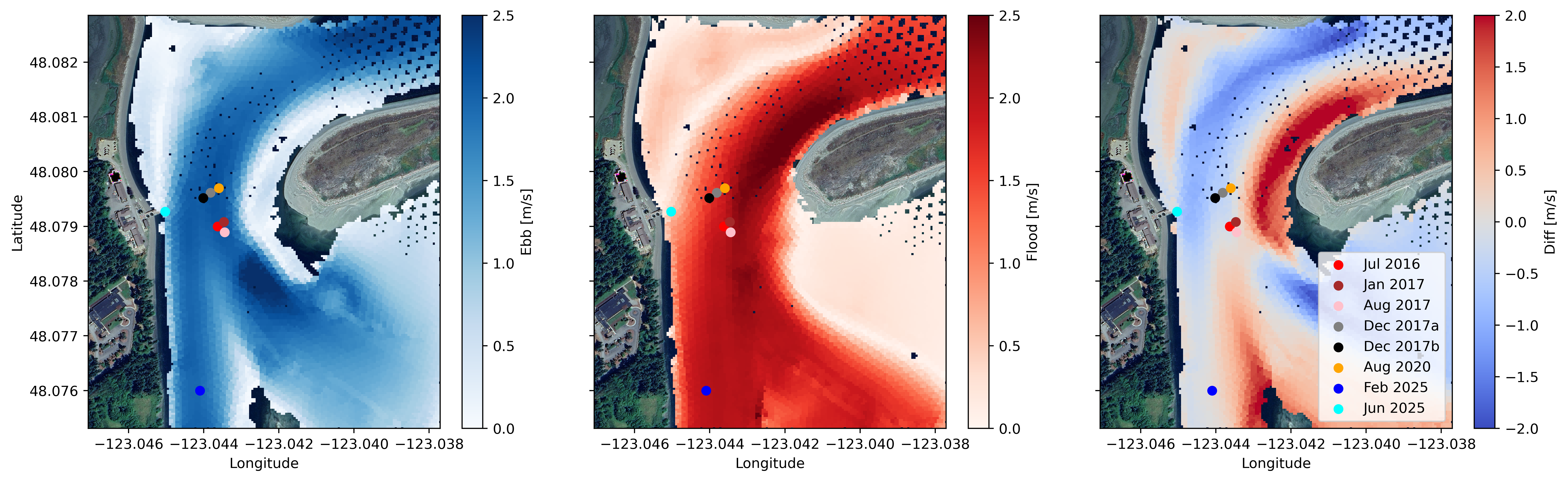
Water Velocity and Turbulence Data from Sequim Bay, WA, 2016 - 2025
Department of Energy —
Collection of publishable datasets from bottom-lander deployments of acoustic Doppler instrumentation in Sequim Bay, WA measured between 2016 and 2025. These data... -
Federal
TEAMER: Initial Testing of Wave Energy-Powered UV-C LED Anti-Biofouling System, Post-Access Report, 3newable LLC
Department of Energy —
Biofouling severely limits the quality of data coming from buoy-mounted sensors. 3newable is co-developing a unique solution to the biofouling problem together with... -
Federal
DCIF Westerly Granite AE Stress Effect Test (Task 3-1)
Department of Energy —
Directional Cooling-Induced Fracturing (DCIF) experiments were conducted on rectangular Westerly granite blocks (width=depth=4.0", height=2.0"). Liquid nitrogen was... -
Federal
Utah FORGE: InSAR Data 2019
Department of Energy —
This dataset contains Interferometric Synthetic Aperture Radar (InSAR) data used for ground deformation monitoring during Phase 2C of the Utah FORGE project. The...
382 datasets found