
-
Federal
EnviroAtlas - Tampa, FL - Estimated Intersection Density of Walkable Roads
U.S. Environmental Protection Agency —
This EnviroAtlas dataset estimates the intersection density of walkable roads within a 750 meter radius of any given 10 meter pixel in the community. Intersections... -
Federal
2023 Cartographic Boundary File (KML), Census Tract for Florida, 1:500,000
U.S. Census Bureau, Department of Commerce —
The 2023 cartographic boundary KMLs are simplified representations of selected geographic areas from the U.S. Census Bureau's Master Address File / Topologically... -
Federal
EnviroAtlas - Tampa, FL - Demographics by Block Group
U.S. Environmental Protection Agency —
This EnviroAtlas dataset is a summary of key demographic groups for the EnviroAtlas community. This dataset was produced by the US EPA to support research and online... -
Federal
EnviroAtlas - Tampa, FL - Potential Window Views of Water by Block Group
U.S. Environmental Protection Agency —
This EnviroAtlas dataset describes the block group population and the percentage of the block group population that has potential views of waterbodies. A potential... -
Federal
TIGER/Line Shapefile, Current, State, Florida, 2020 Census Blocks with Suffixes
U.S. Census Bureau, Department of Commerce —
The TIGER/Line shapefiles and related database files (.dbf) are an extract of selected geographic and cartographic information from the U.S. Census Bureau's Master... -
Federal
Canaveral National Seashore Small-Scale Base GIS Data
Department of the Interior —
This data set contains small-scale base GIS data layers compiled by the National Park Service Servicewide Inventory and Monitoring Program and Water Resources... -
Federal
Single-Beam Bathymetry Sounding Data Offshore from Wiggins Pass to Cape Romano, Florida (2005) in XYZ format
Department of the Interior —
During the last few decades, the coastal environments of south Florida have shown signs of ecological deterioration that has been attributed to changes in freshwater... -
Federal
TIGER/Line Shapefile, 2021, County, Gilchrist County, FL, All Roads
U.S. Census Bureau, Department of Commerce —
The TIGER/Line shapefiles and related database files (.dbf) are an extract of selected geographic and cartographic information from the U.S. Census Bureau's Master... -
Federal
2024 Cartographic Boundary File (KML), County Subdivision for Florida, 1:500,000
U.S. Census Bureau, Department of Commerce —
The 2024 cartographic boundary KMLs are simplified representations of selected geographic areas from the U.S. Census Bureau's Master Address File / Topologically... -
Federal
TIGER/Line Shapefile, 2021, County, Liberty County, FL, All Roads
U.S. Census Bureau, Department of Commerce —
The TIGER/Line shapefiles and related database files (.dbf) are an extract of selected geographic and cartographic information from the U.S. Census Bureau's Master... -
Federal
TIGER/Line Shapefile, 2021, County, Polk County, FL, All Roads
U.S. Census Bureau, Department of Commerce —
The TIGER/Line shapefiles and related database files (.dbf) are an extract of selected geographic and cartographic information from the U.S. Census Bureau's Master... -
Federal
Oceanographic data collected from non-federal stations assembled by the Gulf of America Coastal Ocean Observing System (GCOOS)
National Oceanic and Atmospheric Administration, Department of Commerce —
This dataset contains oceanographic and surface meteorological data collected from non-Federal stations throughout the Gulf of America region of the United States.... -
Federal
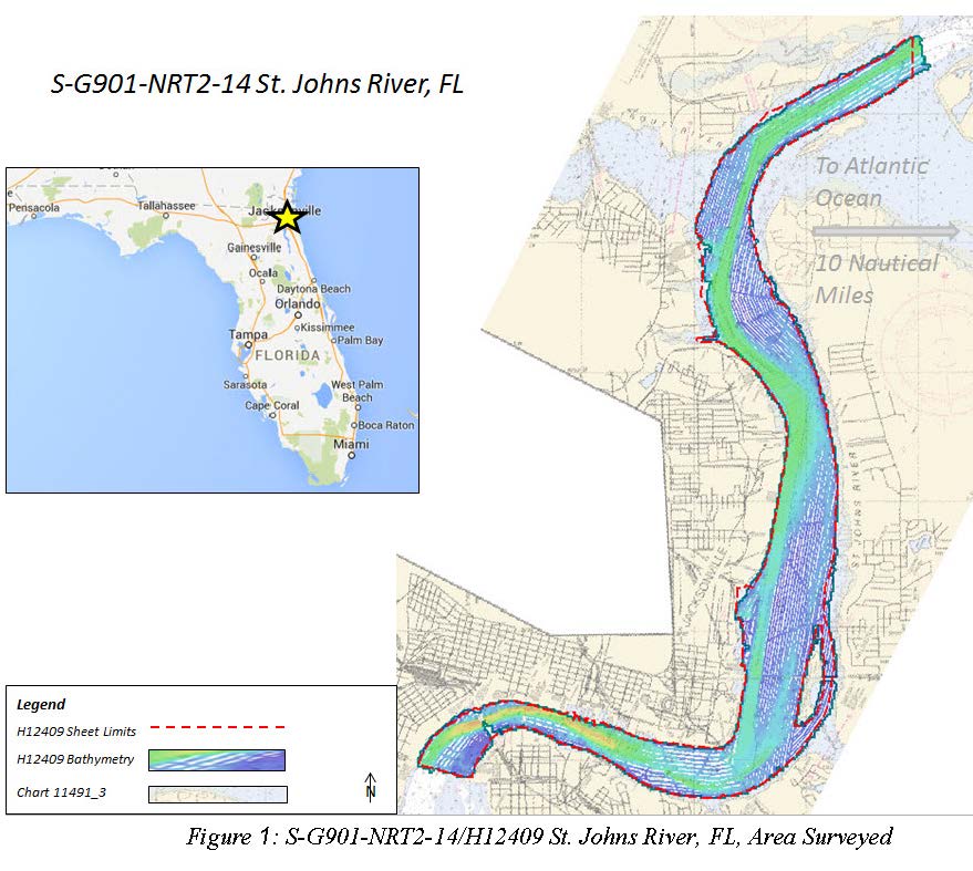
H12409: NOS Hydrographic Survey , 2014-12-03
National Oceanic and Atmospheric Administration, Department of Commerce —
The National Oceanic and Atmospheric Administration (NOAA) has the statutory mandate to collect hydrographic data in support of nautical chart compilation for safe... -
Federal
TIGER/Line Shapefile, 2021, State, Florida, State Legislative Districts Upper Chamber
U.S. Census Bureau, Department of Commerce —
The TIGER/Line shapefiles and related database files (.dbf) are an extract of selected geographic and cartographic information from the U.S. Census Bureau's Master... -
Federal
Uncertainty table for lidar-derived shorelines used when calculating rates in the Digital Shoreline Analysis System software for southeastern Florida (FLse)
Department of the Interior —
Sandy ocean beaches are a popular recreational destination, often surrounded by communities containing valuable real estate. Development is on the rise despite the... -
Federal
TIGER/Line Shapefile, 2024, State, Florida, Topological Faces-Area Landmark Relationship File
U.S. Census Bureau, Department of Commerce —
The TIGER/Line shapefiles and related database files (.dbf) are an extract of selected geographic and cartographic information from the U.S. Census Bureau's Master... -
Federal
Shorelines of the Florida west (FLwest) coastal region used in shoreline change analysis
Department of the Interior —
Sandy ocean beaches are a popular recreational destination, often surrounded by communities containing valuable real estate. Development is on the rise despite the... -
Federal
W00424: NOS Hydrographic Survey , Outside Source Data Surveys - 2017, 2011-09-30
National Oceanic and Atmospheric Administration, Department of Commerce —
The National Oceanic and Atmospheric Administration (NOAA) has the statutory mandate to collect hydrographic data in support of nautical chart compilation for safe... -
Federal
Digital Shoreline Analysis System version 4.3 Transects with Short-Term End Point Rate Calculations for southeastern Florida (FLse)
Department of the Interior —
Sandy ocean beaches are a popular recreational destination, often surrounded by communities containing valuable real estate. Development is on the rise despite the... -
Federal
Fish Inventory at Fort Matanzas National Monument in 2004 - Raw Data
Department of the Interior —
The current dataset provides the raw data results of fish inventory surveys conducted in Fort Matanzas National Monument from 2004. Various trapping/survey methods...

Official websites use .gov
A
.gov website belongs to an official government
organization in the United States.
Secure .gov websites use HTTPS
A
lock (
) or https:// means you’ve safely connected to
the .gov website. Share sensitive information only on official,
secure websites.