
-
Federal
Faults of the Caribbean Region (flt6bg)
Department of the Interior —
This dataset describes faults and structural features of the Caribbean region (Anguilla, Antigua and Barbuda, Aruba, Bahamas, Barbados, Belize, British Virgin... -
Federal
Salt Diapirs in the Gulf Coast [gcdiapirg]
Department of the Interior —
Locations and shapes of salt diapirs were modified after the New Orleans Geological Society map, Salt tectonism of the U.S. Gulf Coast Basin (compiled by J.A. Lopez,... -
Federal
Gridded Population of the World, Version 3 (GPWv3): Land and Geographic Unit Area Grids
National Aeronautics and Space Administration —
The Gridded Population of the World, Version 3 (GPWv3): Land and Geographic Unit Area Grids measure land areas in square kilometers and the mean Unit size... -
Federal
Inventory of landslides triggered by the 2020 Puerto Rico earthquake sequence
Department of the Interior —
Here we present an inventory of remotely and field-observed landslides triggered by 2019-2020 Puerto Rico earthquake sequence. The inventory was mapped using pre- and... -
Federal
Archive of Census Related Products (ACRP): 1990 Census Block Statistics
National Aeronautics and Space Administration —
The 1990 Census Block Statistics portion of the Archive of Census Related Products (ACRP) contains population and housing data from the U.S. Census Bureau's 1990... -
Federal
Global Fertilizer and Manure, Version 1: Phosphorus in Manure Production
National Aeronautics and Space Administration —
The Phosphorus in Manure Production data set of the Global Fertilizer and Manure, Version 1 Data Collection represents the amount of phosphorous in manure produced... -
Federal
SnowEx Mores Creek Summit (MCS) Airborne LiDAR Survey V001
National Aeronautics and Space Administration —
The data set provides digital terrain models (DTM), digital surface models (DSM) snow depth models, and canopy height models (CHM), derived from point cloud data... -
Federal
Ground-Based Global Navigation Satellite System (GNSS) Observation Data (1-second sampling, sub-hourly files) from NASA CDDIS
National Aeronautics and Space Administration —
This dataset consists of ground-based Global Navigation Satellite System (GNSS) Observation Data (1-second sampling, sub-hourly files) from the NASA Crustal Dynamics... -
Federal
GOES-R Geostationary Lightning Mapper (GLM) Gridded Data Products V1
National Aeronautics and Space Administration —
The GOES-R Geostationary Lightning Mapper (GLM) Gridded Data Products consist of full disk extent gridded lightning flash data collected by the Geostationary... -
Federal
OMI/Aura Level 2 Sulphur Dioxide (SO2) Trace Gas Column Data 1-Orbit Subset and Collocated Swath along CloudSat V003 (OMSO2_CPR) at GES DISC
National Aeronautics and Space Administration —
This is a CloudSat-collocated subset of the original product OMSO2, for the purposes of the A-Train mission. The goal of the subset is to select and return OMI data... -
Federal
Level 1.5 Almucantar Inversion Products (except phase functions)
National Aeronautics and Space Administration —
AERONET inversion code provides aerosoloptical properties in the total atmospheric column derived from the direct and diffuse radiation measured byAERONETCimel... -
Federal
MODIS/Terra Global Annual 0.01Deg CMG Snow Cover Climatology V001 NGDA
National Aeronautics and Space Administration —
This data set presents new global snow cover classification regimes derived from the MODIS Terra cloud gap-filled NDSI data (MOD10A1F), elevation, and temperature... -
Federal
ALOS_PALSAR_RTC_HIGH_RES
National Aeronautics and Space Administration —
PALSAR_Radiometric_Terrain_Corrected_high_res -
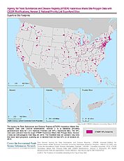
Federal
ATSDR Hazardous Waste Site Polygon Data with CIESIN Modifications, Version 2
National Aeronautics and Space Administration —
The Agency for Toxic Substances and Disease Registry (ATSDR) Hazardous Waste Site Polygon Data with CIESIN Modifications, Version 2 is a database providing... -
Federal
Wilcox Group Apparent Thickness, Gulf Coast (wlcxthkg)
Department of the Interior —
The Apparent Wilcox Group thickness maps are contoured from location and top information derived from the Petroleum Information (PI) Wells database. The Wilcox... -
Federal
DMSP SSM/I-SSMIS Daily Polar Gridded Brightness Temperatures V006
National Aeronautics and Space Administration —
This data set provides daily gridded brightness temperatures derived from passive microwave sensors and distributed in a polar stereographic projection. NSIDC... -
Federal
TOVS GLA 5 DAY GRIDS from NOAA-12 V01 (TOVSA5ND) at GES DISC
National Aeronautics and Space Administration —
This dataset (TOVSA5ND) contains the TIROS Operational Vertical Sounder (TOVS) level 3 geophysical parameters derived using data from NOAA-12 and the physical... -
Federal
Multilayer Greenland Ice Surface Temperature, Surface Albedo, and Water Vapor from MODIS V001 NGDA
National Aeronautics and Space Administration —
This multilayer data set includes standard MODIS Collection 6.1 ice surface temperature (IST) and derived melt map, as well as MODIS Collection 6.0 albedo and water... -
Federal
IceBridge ATM L1B Near-Infrared Waveforms V001
National Aeronautics and Space Administration —
This data set contains geolocated waveforms of Greenland, Arctic, and Antarctic sea ice measured by the Airborne Topographic Mapper (ATM) near-infrared (NIR) lidar....

Official websites use .gov
A
.gov website belongs to an official government
organization in the United States.
Secure .gov websites use HTTPS
A
lock (
) or https:// means you’ve safely connected to
the .gov website. Share sensitive information only on official,
secure websites.