
-
Federal
MODIS/Terra Vegetation Indices Monthly L3 Global 1km SIN Grid V006
National Aeronautics and Space Administration —
The MOD13A3 Version 6 data product was decommissioned on July 31, 2023. Users are encouraged to use the MOD13A3... -
Federal
VIIRS/SNPP Deep Blue Aerosol L2 6-Min Swath 6 km (v2.0)
National Aeronautics and Space Administration —
The Suomi National Polar-orbiting Partnership (SNPP) Visible Infrared Imaging Radiometer Suite (VIIRS) NASA standard Level-2 (L2) deep blue aerosol product provides... -
Federal
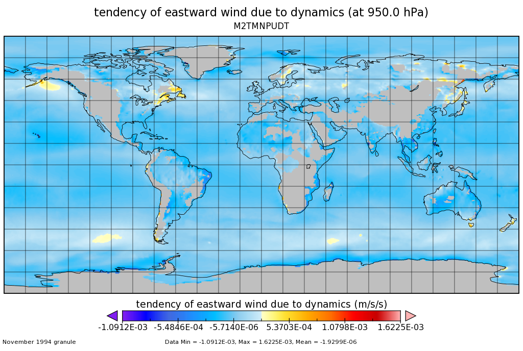
MERRA-2 tavgM_3d_udt_Np: 3d,Monthly mean,Time-Averaged,Pressure-Level,Assimilation,Wind Tendencies 0.625 x 0.5 degree V5.12.4 (M2TMNPUDT) at GES DISC
National Aeronautics and Space Administration —
M2TMNPUDT (or tavgM_3d_udt_Np) is a 3-dimensional monthly mean data collection in Modern-Era Retrospective analysis for Research and Applications version 2 (MERRA-2).... -
Federal
MODIS/Terra+Aqua Land Cover Type Yearly L3 Global 0.05Deg CMG V061
National Aeronautics and Space Administration —
The Terra and Aqua combined Moderate Resolution Imaging Spectroradiometer (MODIS) Land Cover Climate Modeling Grid (CMG) (MCD12C1) Version 6.1 data product provides a... -
Federal
FIREX-AQ DC-8 High-Spectral Resolution Lidar (HSRL) Remotely Sensed Data
National Aeronautics and Space Administration —
FIREXAQ_HSRL_AircraftRemoteSensing_DC8_Data are remotely sensed data collected by the High-Spectral Resolution Lidar (HSRL) onboard the DC-8 aircraft during FIREX-AQ.... -
Federal
Modeled Daily Thaw Depth and Frozen Ground Depth, Version 1
National Aeronautics and Space Administration —
This data set contains modeled daily thaw depth and freezing depth for the Arctic terrestrial drainage basin. Thaw and freezing depths were calculated over the study... -
Federal
AHI/Himawari-09 Dark Target Aerosol 10-Min L2 Full Disk 10 km
National Aeronautics and Space Administration —
The AHI/Himawari-09 Dark Target Aerosol 10-Min L2 Full Disk 10 km product, short-name XAERDT_L2_AHI_H09 is provided at 10-km spatial resolution (at-nadir) and a... -
Federal
Aquarius CAP Level 3 Sea Surface Salinity Standard Mapped Image 7-Day Data V5.0
National Aeronautics and Space Administration —
Version 5.0 Aquarius CAP Level 3 products are the fourth release of the AQUARIUS/SAC-D mapped salinity and wind speed data based on the Combined Active Passive (CAP)... -
Federal
CLPX-Ground: Ground-Based Frequency Modulated Continuous Wave (FMCW) Radar, Version 1
National Aeronautics and Space Administration —
This data set is comprised of FMCW radar measurements, which are sensitive to electromagnetic discontinuities in the snowpack made during the 2002 and 2003 Cold Land... -
Federal
CPEX-AW HALO Aerosol and Water Vapor Profiles and Images
National Aeronautics and Space Administration —
CPEXAW-HALO_DC8_1 is the High Altitude Lidar Observatory (HALO) image and h5 data files collected during the Convective Processes Experiment - Aerosols & Winds... -
Federal
Antarctic 1 km Digital Elevation Model (DEM) from Combined ERS-1 Radar and ICESat Laser Satellite Altimetry, Version 1
National Aeronautics and Space Administration —
This data set provides a 1 km resolution Digital Elevation Model (DEM) of Antarctica. The DEM combines measurements from the European Remote Sensing Satellite-1... -
Federal
Arctic Boreal Annual Burned Area, Circumpolar Boreal Forest and Tundra, V2, 2002-2022
National Aeronautics and Space Administration —
This dataset provides annual cumulative end-of-season burned area in circumpolar boreal forests and tundra for the years 2002-2022. The data were generated using the... -
Federal
LBA-ECO LC-14 Specific Leaf Area and Phenology, km 67 Site, Para, Brazil: 2001-2006
National Aeronautics and Space Administration —
This data set provides measurements of specific leaf area and monthly phenological observations for selected tree and vine species at the km 67 Seca Floresta site,... -
Federal
JPL SMAP Level 2B Near Real-time CAP Sea Surface Salinity V5.0 Validated Dataset
National Aeronautics and Space Administration —
This is the PI-produced JPL SMAP-SSS V5.0, level 2B NRT CAP, validated sea surface salinity (SSS) and extreme winds orbital/swath product from the NASA Soil Moisture... -
Federal
Global Navigation Satellite System (GNSS) IGS Combined Final Clock Solution Comparison Summary Product from NASA CDDIS
National Aeronautics and Space Administration —
This derived product set consists of Global Navigation Satellite System Final Clock Product Summary from the NASA Crustal Dynamics Data Information System (CDDIS).... -
Federal
Multi-Satellite Air Quality Sulfur Dioxide (SO2) Database Long-Term L4 Global V2 (MSAQSO2L4) at GES DISC
National Aeronautics and Space Administration —
These data are a part of Multi-Decadal Sulfur Dioxide (SO2) Climatology from Satellite Instruments (MEaSUREs-12-0022 project). Version 2 of the global catalogue of... -
Federal
Global Monthly EASE-Grid Snow Water Equivalent Climatology, Version 1
National Aeronautics and Space Administration —
This data set comprises global, monthly satellite-derived Snow Water Equivalent (SWE) climatologies from November 1978 through May 2007, with periodic updates... -
Federal
VIIRS/NPP Moderate Resolution Bands L1B 6-Min Swath 750m NRT
National Aeronautics and Space Administration —
The VIIRS Level 1 and Level 2 swath products are generated from the processing of 6 minutes of VIIRS data acquired during the S-NPP satellite overpass. The VIIRS... -
Federal
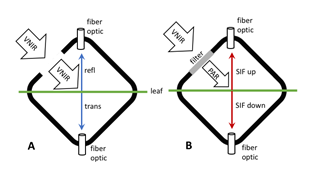
Tundra Plant Leaf-level Spectral Reflectance and Chlorophyll Fluorescence, 2019-2021
National Aeronautics and Space Administration —
This dataset provides leaf-level visible-near infrared spectral reflectance, chlorophyll fluorescence spectra, species, plant functional type (PFT), and chlorophyll...

Official websites use .gov
A
.gov website belongs to an official government
organization in the United States.
Secure .gov websites use HTTPS
A
lock (
) or https:// means you’ve safely connected to
the .gov website. Share sensitive information only on official,
secure websites.