
-
Federal
National Assessment of Oil and Gas Project - Appalachian Basin Province (067) Total Petroleum Systems
Department of the Interior —
The Total Petroleum System is used in the National Assessment Project and incorporates the Assessment Unit, which is the fundamental geologic unit used for the... -
Federal
IVR EFP Database
National Oceanic and Atmospheric Administration, Department of Commerce —
This database contains trip-level reports submitted by vessels participating in Exempted Fishery projects with IVR reporting requirements. -
Federal
VA Use Of SSA Earnings Data (VA-EARN)
Social Security Administration —
The purpose of this matching program is to provide the Department of Veterans Affairs (VA), both the Veterans Benefit Administration (VBA) and Veterans Health... -
Federal
Real Property Project Tracking System (RPPTS)
Department of Veterans Affairs —
The Real Property Project Tracking System (RPPTS), formerly known as the Lease/Project Tracking (LEASE) database, contains information about lease and land projects... -
Federal
points, transects, beach width: Barrier island geomorphology and shorebird habitat metrics at 50-m alongshore transects and 5-m cross-shore points: Cobb Island, VA, 2014
Department of the Interior —
Understanding how sea-level rise will affect coastal landforms and the species and habitats they support is critical for crafting approaches that balance the needs of... -
Federal
2 Observations: Deep learning approaches for improving prediction of daily stream temperature in data-scarce, unmonitored, and dammed basins
Department of the Interior —
This data release component contains mean daily stream water temperature observations, retrieved from the USGS National Water Information System (NWIS) and used to... -
Federal
Vessel Logbook Database
National Oceanic and Atmospheric Administration, Department of Commerce —
This database contains the primary data reported on the vessel trip reports by vessel operators. -
Federal
Suicide Among Veterans and Other Americans 2001–2014 Report
Department of Veterans Affairs —
This report provides information regarding suicide mortality for the years 2001–2014. It incorporates the most recent mortality data from the VA/Department of Defense... -
Federal
TIGER/Line Shapefile, Current, State, Virginia, Topological Faces-Area Landmark Relationship File
U.S. Census Bureau, Department of Commerce —
The TIGER/Line shapefiles and related database files (.dbf) are an extract of selected geographic and cartographic information from the U.S. Census Bureau's Master... -
Federal
2023 Cartographic Boundary File (SHP), State Legislative District (SLD) Upper Chamber for Virginia, 1:500,000
U.S. Census Bureau, Department of Commerce —
The 2023 cartographic boundary shapefiles are simplified representations of selected geographic areas from the U.S. Census Bureau's Master Address File /... -
Federal
Aerial Photography 2004, Color Infrared Harpers Ferry National Historical Park
Department of the Interior —
This color infrared imagery covers the area in and around the Harpers Ferry National Historical Park (HAFE). The photographs were taken in 2004 and published in 2006.... -
Federal
ElevMHW: Elevation adjusted to local mean high water: Cedar Island, VA, 2010
Department of the Interior —
Understanding how sea-level rise will affect coastal landforms and the species and habitats they support is critical for crafting approaches that balance the needs of... -
County
Census 2020 Block
Fairfax County, Virginia —
The 2020 decennial census blocks within Fairfax County. This data was acquired from the US Census Bureau, with fields slightly customized by Fairfax County... -
Federal
National Assessment of Oil and Gas Project - Appalachian Basin Province (067) Assessment Units
Department of the Interior —
The Assessment Unit is the fundamental unit used in the National Assessment Project for the assessment of undiscovered oil and gas resources. The Assessment Unit is... -
Federal
2023 Cartographic Boundary File (SHP), Census Tract for Virginia, 1:500,000
U.S. Census Bureau, Department of Commerce —
The 2023 cartographic boundary shapefiles are simplified representations of selected geographic areas from the U.S. Census Bureau's Master Address File /... -
Federal
George Washington Memorial Parkway Small-Scale Base GIS Data
Department of the Interior —
This data set contains small-scale base GIS data layers compiled by the National Park Service Servicewide Inventory and Monitoring Program and Water Resources... -
Federal
Aerial Photography 2004, Color Infrared Wolf Trap National Park for the Performing Arts
Department of the Interior —
This color infrared imagery covers the area in and around the Wolf Trap National Park for the Performing Arts (WOTR). The photographs were taken in 2004 and published... -
Federal
DCpts, DTpts, SLpts: Dune crest, dune toe, and mean high water shoreline positions: Smith Island, VA, 2014
Department of the Interior —
Understanding how sea-level rise will affect coastal landforms and the species and habitats they support is critical for crafting approaches that balance the needs of... -
Federal
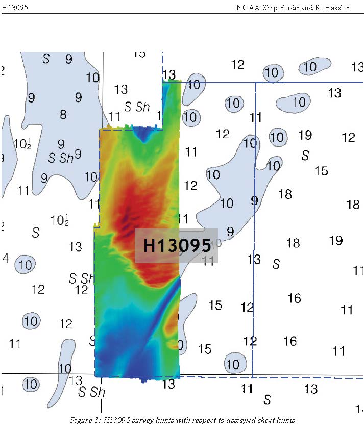
H13095: NOS Hydrographic Survey , 2018-11-01
National Oceanic and Atmospheric Administration, Department of Commerce —
The National Oceanic and Atmospheric Administration (NOAA) has the statutory mandate to collect hydrographic data in support of nautical chart compilation for safe... -
Federal
2020 Cartographic Boundary File (KML), Current Census Tract for Virginia, 1:500,000
U.S. Census Bureau, Department of Commerce —
The 2020 cartographic boundary KMLs are simplified representations of selected geographic areas from the U.S. Census Bureau's Master Address File / Topologically...

Official websites use .gov
A
.gov website belongs to an official government
organization in the United States.
Secure .gov websites use HTTPS
A
lock (
) or https:// means you’ve safely connected to
the .gov website. Share sensitive information only on official,
secure websites.