
-
Federal
W00379: NOS Hydrographic Survey , 2014-06-27
National Oceanic and Atmospheric Administration, Department of Commerce —
The National Oceanic and Atmospheric Administration (NOAA) has the statutory mandate to collect hydrographic data in support of nautical chart compilation for safe... -
Federal
H13349: NOS Hydrographic Survey , 2021-07-01
National Oceanic and Atmospheric Administration, Department of Commerce —
The National Oceanic and Atmospheric Administration (NOAA) has the statutory mandate to collect hydrographic data in support of nautical chart compilation for safe... -
Federal
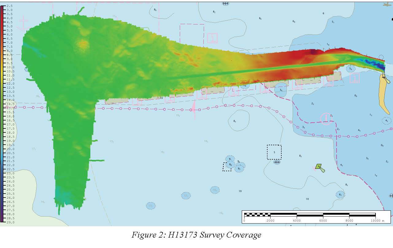
H13173: NOS Hydrographic Survey , 2019-07-21
National Oceanic and Atmospheric Administration, Department of Commerce —
The National Oceanic and Atmospheric Administration (NOAA) has the statutory mandate to collect hydrographic data in support of nautical chart compilation for safe... -
Federal
H12984: NOS Hydrographic Survey , 2017-10-15
National Oceanic and Atmospheric Administration, Department of Commerce —
The National Oceanic and Atmospheric Administration (NOAA) has the statutory mandate to collect hydrographic data in support of nautical chart compilation for safe... -
Federal
H13175: NOS Hydrographic Survey , 2019-06-18
National Oceanic and Atmospheric Administration, Department of Commerce —
The National Oceanic and Atmospheric Administration (NOAA) has the statutory mandate to collect hydrographic data in support of nautical chart compilation for safe... -
Federal
TIGER/Line Shapefile, 2021, County, Monroe County, FL, All Roads
U.S. Census Bureau, Department of Commerce —
The TIGER/Line shapefiles and related database files (.dbf) are an extract of selected geographic and cartographic information from the U.S. Census Bureau's Master... -
Federal
2020 Cartographic Boundary File (SHP), Current Block Group for Florida, 1:500,000
U.S. Census Bureau, Department of Commerce —
The 2020 cartographic boundary shapefiles are simplified representations of selected geographic areas from the U.S. Census Bureau's Master Address File /... -
Federal
H12978: NOS Hydrographic Survey , 2017-11-01
National Oceanic and Atmospheric Administration, Department of Commerce —
The National Oceanic and Atmospheric Administration (NOAA) has the statutory mandate to collect hydrographic data in support of nautical chart compilation for safe... -
Federal
H12717: NOS Hydrographic Survey , 2015-02-20
National Oceanic and Atmospheric Administration, Department of Commerce —
The National Oceanic and Atmospheric Administration (NOAA) has the statutory mandate to collect hydrographic data in support of nautical chart compilation for safe... -
Federal
TIGER/Line Shapefile, 2021, County, Flagler County, FL, All Roads
U.S. Census Bureau, Department of Commerce —
The TIGER/Line shapefiles and related database files (.dbf) are an extract of selected geographic and cartographic information from the U.S. Census Bureau's Master... -
Federal
Province Boundaries for the National Assessment of Oil and Gas - Gulf Coast Region
Department of the Interior —
The USGS Central Region Energy Team assesses oil and gas resources of the United States. The onshore and State water areas of the United States comprise 71 provinces.... -
Federal
Metabolism estimates for 356 U.S. rivers (2007-2017): 1. Site data
Department of the Interior —
This dataset provides site identifiers, details, and quality indicators. The format is a table with 1 row per site (tab-delimited file). This dataset is part of a... -
Federal
2024 Cartographic Boundary File (KML), State Legislative District (SLD) Lower Chamber for Florida, 1:500,000
U.S. Census Bureau, Department of Commerce —
The 2024 cartographic boundary KMLs are simplified representations of selected geographic areas from the U.S. Census Bureau's Master Address File / Topologically... -
Federal
2022 Cartographic Boundary File (SHP), Current Block Group for Florida, 1:500,000
U.S. Census Bureau, Department of Commerce —
The 2022 cartographic boundary shapefiles are simplified representations of selected geographic areas from the U.S. Census Bureau's Master Address File /... -
Federal
TIGER/Line Shapefile, 2021, County, Calhoun County, FL, All Roads
U.S. Census Bureau, Department of Commerce —
The TIGER/Line shapefiles and related database files (.dbf) are an extract of selected geographic and cartographic information from the U.S. Census Bureau's Master... -
Federal
BLM ES SO National Recreation Site Polygons
Department of the Interior —
This polygon feature class represents the boundaries of the Bureau of Land Management (BLM) Eastern States (ES) recreation sites. Recreation sites can include parking... -
Federal
EnviroAtlas - Tampa, FL - Park Access by Block Group
U.S. Environmental Protection Agency —
This EnviroAtlas dataset shows the block group population that is within and beyond an easy walking distance (500m) of a park entrance. Park entrances were included... -
Federal
BLM ES SO National Recreation Site Points
Department of the Interior —
This point feature class represents the Bureau of Land Management (BLM) Eastern States (ES) recreation sites. Recreation sites can include parking areas, campgrounds,... -
Federal
Single-Beam Bathymetry Sounding Data of Shark River and Trout Creek, Florida (2004) in XYZ file format
Department of the Interior —
During the past century, river and tidal creeks through the coastal wetlands of the Everglades have filled with sediment and vegetation of surrounding landscapes to... -
Federal
2024 Cartographic Boundary File (KML), State Legislative District (SLD) Upper Chamber for Florida, 1:500,000
U.S. Census Bureau, Department of Commerce —
The 2024 cartographic boundary KMLs are simplified representations of selected geographic areas from the U.S. Census Bureau's Master Address File / Topologically...

Official websites use .gov
A
.gov website belongs to an official government
organization in the United States.
Secure .gov websites use HTTPS
A
lock (
) or https:// means you’ve safely connected to
the .gov website. Share sensitive information only on official,
secure websites.