
-
Federal
SMAP_L1A_RADAR_RECEIVE_ONLY_METADATA_V001
National Aeronautics and Space Administration —
SMAP Level 1A Radar Receive Only Product Metadata Version 1 -
Federal
USGS Global Forest Observations Initiative (GFOI) Cameroon
National Aeronautics and Space Administration —
The Global Forest Observations Initiative (GFOI) is an initiative of the inter-governmental Group on Earth Observations (GEO) that aims to: foster the sustained... -
Federal
CLASIC07 In Situ Vegetation Data V001
National Aeronautics and Space Administration —
This data set includes in situ vegetation data collected during the Cloud and Land Surface Interaction Campaign 2007 (CLASIC07) campaign. Sampling was designed to... -
Federal
National Assessment of Oil and Gas in Jurassis-Cretaceous Strata Gulf Coast, 2010 (Provinces 047, 048 and 049) Assessment Units
Department of the Interior —
The Assessment Unit is the fundamental unit used in the National Assessment Project for the assessment of undiscovered oil and gas resources. The Assessment Unit is... -
Federal
Global Grid of Probabilities of Urban Expansion to 2030
National Aeronautics and Space Administration —
The Global Grid of Probabilities of Urban Expansion to 2030 presents spatially explicit probabilistic forecasts of global urban land cover change from 2000 to 2030 at... -
Federal
GHRSST L2P NOAA/ACSPO GOES-18/ABI America Region Sea Surface Temperature v2.90 dataset
National Aeronautics and Space Administration —
The G18-ABI-L2P-ACSPO-v2.90 dataset produced by the NOAA Advanced Clear Sky Processor for Ocean (ACSPO) system is used to derive Sea Surface Skin Temperature (SST)... -
Federal
OCO-3 Level 2 meteorological parameters interpolated from global assimilation model for each sounding, Forward Processing V10 (OCO3_L2_Met) at GES DISC
National Aeronautics and Space Administration —
Version 10 is the current version of the data set. Older versions will no longer be available and are superseded by Version 10. The Orbiting Carbon Observatory -3... -
Federal
USGS Global Forest Observations Initiative (GFOI) Guatemala
National Aeronautics and Space Administration —
The Global Forest Observations Initiative (GFOI) is an initiative of the inter-governmental Group on Earth Observations (GEO) that aims to: foster the sustained... -
Federal
Shaded Relief Image of the Caribbean Region (shadedrelief.jpg)
Department of the Interior —
This composite shaded relief image dataset depicts generalized bathymetry and topography of the Caribbean region. -
Federal
SMAPVEX12 Soil Texture Map V001
National Aeronautics and Space Administration —
This data set consists of soil texture classification data derived from field surveys as part of the Soil Moisture Active Passive Validation Experiment 2012... -
Federal
Inventory Data of Lowland-Breeding Birds and Associated Vegetation Types on the Alaska Peninsula, 2004-2007 - Raw Data
Department of the Interior —
These are raw field data from a stratified random survey to inventory the birds breeding in lowlands (elevation below 100m) of the Alaska Peninsula, during summers... -
Federal
Gridded Data from Multibeam Bathymetric Surveys of Eklutna, Kenai, and Skilak Lakes, Alaska
Department of the Interior —
This dataset contains bathymetric depth values for three lakes in southcentral Alaska: Eklutna Lake near the city of Anchorage, Kenai Lake near the city of Cooper... -
Federal
2014 Environmental Performance Index (EPI)
National Aeronautics and Space Administration —
The 2014 Environmental Performance Index (EPI) ranks 178 countries on 20 performance indicators in the following 9 policy categories: health impacts, air quality,... -
Federal
An Updated Vs30 Map for California with Geologic and Topographic Constraints (ver. 1.1, July 2022)
Department of the Interior —
This data release provides a map of the time-averaged shear-wave velocity in the upper 30 m (Vs30) for California using the method described by Thompson and others... -
Federal
ER-2 Navigation Data IMPACTS V1
National Aeronautics and Space Administration —
The NASA ER-2 Navigation Data IMPACTS dataset contains information recorded by the on-board navigation and data collection systems of the NASA ER-2 high-altitude... -
Federal
MODIS/Terra Snow Cover Daily L3 Global 500m SIN Grid V061 NGDA
National Aeronautics and Space Administration —
This global Level-3 (L3) data set provides a daily composite of snow cover and albedo derived from the 'MODIS/Terra Snow Cover 5-Min L2 Swath 500m' data set... -
Federal
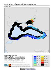
Indicators of Coastal Water Quality: Change in Chlorophyll-a Concentration 1998-2007
National Aeronautics and Space Administration —
The Change in Chlorophyll-a Concentrations 1998-2007 component of the Indicators of Coastal Water Quality Collection represents a tabular time series of the... -
Federal
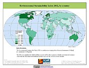
2002 Environmental Sustainability Index (ESI)
National Aeronautics and Space Administration —
The 2002 Environmental Sustainability Index (ESI) measures overall progress toward environmental sustainability for 142 countries based on environmental systems,... -
Federal
Sentinel-5P TROPOMI Near-Real-Time (NRT) Total Ozone Column 1-Orbit L2 5.5km x 3.5km V2 (S5P_L2__O3_TOT_HiR_NRT) at GES DISC
National Aeronautics and Space Administration —
The Sentinel-5P TROPOMI Near Real Time (NRT) Total Ozone Column 1-Orbit L2 5.5km x 3.5km V2 (S5P_L2__O3_TOT_HiR_NRT) at GES DISC is the near real time version of the...

Official websites use .gov
A
.gov website belongs to an official government
organization in the United States.
Secure .gov websites use HTTPS
A
lock (
) or https:// means you’ve safely connected to
the .gov website. Share sensitive information only on official,
secure websites.