
-
Federal
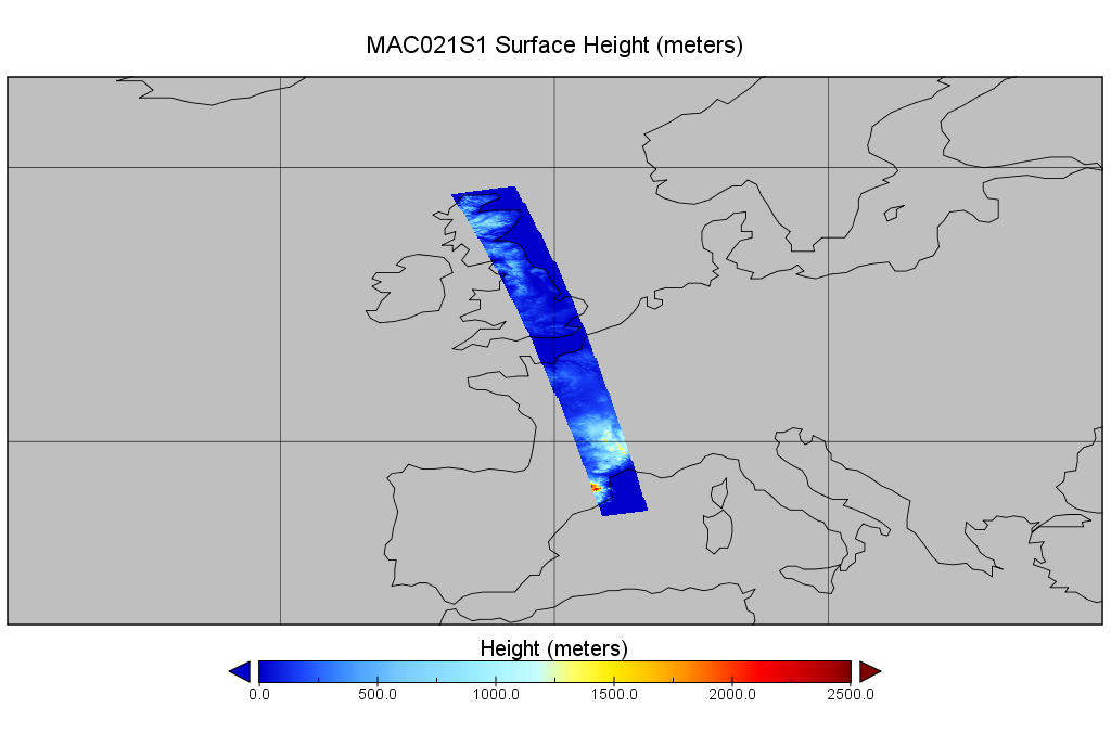
MODIS/Aqua Calibrated Radiances 250m 5-Min L1B Wide Swath Subset along CloudSat V002 (MAC02QS1) at GES DISC
National Aeronautics and Space Administration —
This is the wide-swath MODIS/Aqua subset along CloudSat field of view track. The goal of the wide-swath subset is to select and return MODIS data that are within... -
Federal
MMS 4 Magnetic Ephemeris and Coordinates (MEC) and Support (Tsyganenko 1989 model, Dynamic conditions), Level 2 (L2), Burst Mode, 30 ms Data
National Aeronautics and Space Administration —
Magnetospheric Multiscale 4 (MMS 4) spacecraft position, velocity, attitude, angular momentum vector, and magnetic ephemeris and coordinates (MEC), Level-2 science... -
Federal
MERRA-2 tavgU_2d_lnd_Nx: 2d,diurnal,Time-Averaged,Single-Level,Assimilation,Land Surface Diagnostics 0.625 x 0.5 degree V5.12.4 (M2TUNXLND) at GES DISC
National Aeronautics and Space Administration —
M2TUNXLND (or tavgU_2d_lnd_Nx) is a time-averaged 2-dimensional monthly diurnal means data collection in Modern-Era Retrospective analysis for Research and... -
Federal
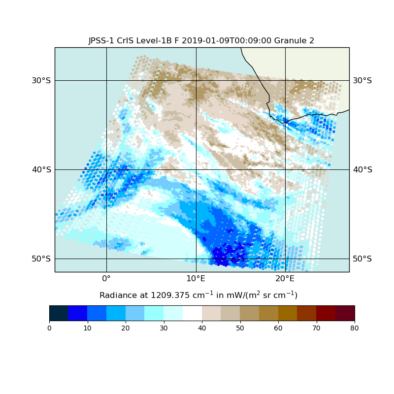
JPSS-1 CrIS Level 1B Full Spectral Resolution V2 (SNDRJ1CrISL1B) at GES DISC
National Aeronautics and Space Administration —
The Cross-track Infrared Sounder (CrIS) Level 1B Full Spectral Resolution (FSR) data files contain radiance measurements along with ancillary spacecraft, instrument,... -
Federal
Big Box Retail Grocery Store and Electric Vehicle Station Load Profiles
Department of Energy —
This dataset includes yearlong, one-minute resolution time series profiles for the big box retail grocery stores stores simulated in Phoenix, Houston, Denver, and... -
Federal
Effect of microgravity on an animal-bacteria symbiosis
National Aeronautics and Space Administration —
Spaceflight imposes numerous adaptive challenges for terrestrial life. The reduction in gravity, or microgravity, represents a novel environment that can disrupt... -
Federal
Astrographic Catalog of Reference Stars
National Aeronautics and Space Administration —
For a number of years there has been a great demand for a high-density catalog of accurate stellar positions and proper motions that maintains a consistent system of... -
Federal
Global Vegetation Height Metrics from GEDI and ICESat2
National Aeronautics and Space Administration —
This dataset provides global rasters of relative height metrics for vegetation from Global Ecosystem Dynamics Investigation (GEDI) L2A data and Ice, Cloud, and Land... -
Federal
CloudCV 10-Second Sky Images and Irradiance Dataset
Department of Energy —
The CloudCV 10-Second Sky Image and Irradiance Dataset contains sky images and irradiance measurements recorded every 10 seconds during daylight hours for 90 days... -
Federal
VIIRS/NPP Active Fires 6-Min L2 Swath 375m - NRT
National Aeronautics and Space Administration —
The VNP14IMG_NRT is a Near Real Time (NRT) S-NPP/VIIRS 375 m active fire detection data product (Schroeder 2014). The product is built on the EOS/MODIS fire product... -
Federal
Land Resources of Russia -- Maps of Soil Characteristics, Version 1
National Aeronautics and Space Administration —
This data set consists of maps of various soil characteristics for all of Russia. The maps are available as ESRI Shapefiles and they are accompanied by databases of... -
Federal
IceBridge Sea Ice Freeboard, Snow Depth, and Thickness Quick Look, Version 1
National Aeronautics and Space Administration —
This data set is an evaluation product containing derived geophysical data products retrieved over the Arctic sea ice cover, using the IceBridge Airborne Topographic... -
Federal
U.S. Solar Photovoltaic System and Energy Storage Cost Benchmarks: Q1 2021
Department of Energy —
NREL has been modeling U.S. solar photovoltaic (PV) system costs since 2009. This year, our report benchmarks costs of U.S. PV for residential, commercial, and... -
Federal
GPM IMERG Final Precipitation L3 1 month 0.1 degree x 0.1 degree V07 (GPM_3IMERGM) at GES DISC
National Aeronautics and Space Administration —
Version 07B is the current version of the IMERG data sets. Older versions will no longer be available and have been superseded by Version 07. The Integrated Multi-... -
Federal
Experimental data sets for viscosity and surface tension of binary mixtures at the temperatures (293.15 to 323.15) K and the pressures (99.325 to 103.325) kPa
National Institute of Standards and Technology —
This is a research data set extracted from NIST Standard Reference Database 103b and contains raw experimental data for viscosity and surface tension of binary mixtures. -
Federal
AHI/Himawari-08 Dark Target Aerosol 10-Min L2 Full Disk 10 km
National Aeronautics and Space Administration —
The AHI/Himawari-08 Dark Target Aerosol 10-Min L2 Full Disk 10 km product, short-name XAERDT_L2_AHI_H08 is provided at 10-km spatial resolution (at-nadir) and a... -
Federal
Archive of Chandra Cluster Entropy Profile Tables (ACCEPT) Catalog
National Aeronautics and Space Administration —
This table, the Archive of Chandra Cluster Entropy Profile Tables (ACCEPT) Catalog, contains the radial entropy profiles of the intracluster medium (ICM) for a... -
Federal
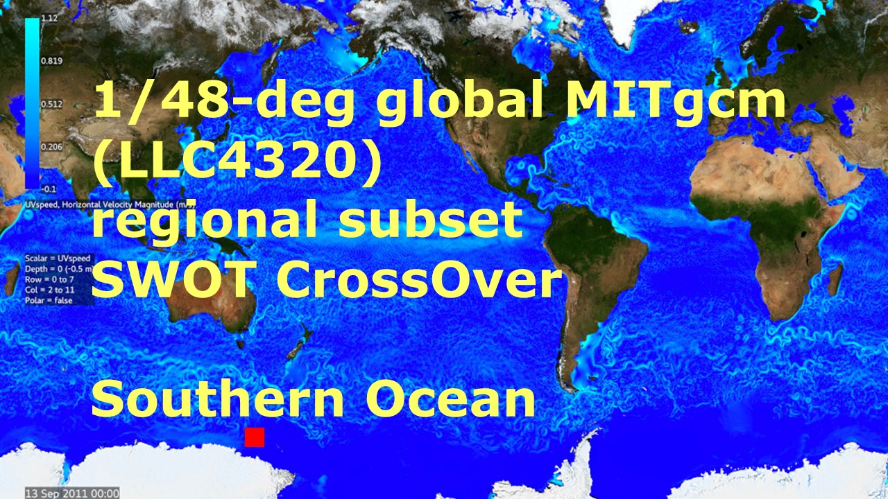
Southern Ocean Pre-SWOT Level-4 Hourly MITgcm LLC4320 Native Grid 2km Oceanographic Dataset Version 1.0
National Aeronautics and Space Administration —
This dataset provides a regional multivariate oceanographic state estimate from a global ocean numerical simulation with a focus on the Southern Ocean region. The... -
Federal
Global Navigation Satellite System (GNSS) IGS Summary of Orbit and Clock Comparisons of Analysis Center (AC) and Combination Real-Time Solutions with IGS Rapid Solutions from NASA CDDIS
National Aeronautics and Space Administration —
This derived product set consists of a summary comparing the International GNSS Service (IGS) Real-Time Service (RTS) orbit and clock products from all analysis...

Official websites use .gov
A
.gov website belongs to an official government
organization in the United States.
Secure .gov websites use HTTPS
A
lock (
) or https:// means you’ve safely connected to
the .gov website. Share sensitive information only on official,
secure websites.