
-
Federal
Gridded Population of the World, Version 3 (GPWv3): Population Count Grid, Future Estimates
National Aeronautics and Space Administration —
The Gridded Population of the World, Version 3 (GPWv3): Population Count Grid, Future Estimates consists of estimates of human population for the years 2005, 2010,... -
State
Census 2000 and 2010 Population, Villages
State of New York —
Total Populations of Villages - 2000 and 2010 -
University
New Mexico Census Tracts, Total Population (2010)
Earth Data Analysis Center, University of New Mexico —
The once-a-decade decennial census was conducted in April 2010 by the U.S. Census Bureau. This count of every resident in the United States was mandated by Article I,... -
Federal
The Atlantic Tradewind Ocean-Atmosphere Mesoscale Interaction Campaign (ATOMIC), Barbados, Jan 17 - Feb 12, 2020
National Oceanic and Atmospheric Administration, Department of Commerce —
The Atlantic Tradewind Ocean-Atmosphere Mesoscale Interaction Campaign (ATOMIC) was a field campaign held January-February 2020 in the tropical North Atlantic east of... -
University
San Miguel County Blocks, Age by 5-Year Age Groups for Females (2010)
Earth Data Analysis Center, University of New Mexico —
The once-a-decade decennial census was conducted in April 2010 by the U.S. Census Bureau. This count of every resident in the United States was mandated by Article I,... -
University
Quay County Blocks, Age by 5-Year Age Groups for Males (2010)
Earth Data Analysis Center, University of New Mexico —
The once-a-decade decennial census was conducted in April 2010 by the U.S. Census Bureau. This count of every resident in the United States was mandated by Article I,... -
University
Socorro County Block Groups, Total Population (2010)
Earth Data Analysis Center, University of New Mexico —
The once-a-decade decennial census was conducted in April 2010 by the U.S. Census Bureau. This count of every resident in the United States was mandated by Article I,... -
University
San Miguel County Block Groups, Race and Hispanic Ethnicity (2010)
Earth Data Analysis Center, University of New Mexico —
The once-a-decade decennial census was conducted in April 2010 by the U.S. Census Bureau. This count of every resident in the United States was mandated by Article I,... -
University
Sandoval County Blocks, Race and Hispanic Ethnicity (2010)
Earth Data Analysis Center, University of New Mexico —
The once-a-decade decennial census was conducted in April 2010 by the U.S. Census Bureau. This count of every resident in the United States was mandated by Article I,... -
State
Correctional Facility Daily Population Count By Facility
State of Connecticut —
CT Department of Correction Facility Population Count by Date, By Status, Filter by Facility -
Federal
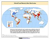
Global Flood Mortality Risks and Distribution
National Aeronautics and Space Administration —
The Global Flood Mortality Risks and Distribution is a 2.5 minute grid of global flood mortality risks. Gridded Population of the World, Version 3 (GPWv3) data... -
Federal
AMLR station hydrographic data 1995-2011 v2-0
National Oceanic and Atmospheric Administration, Department of Commerce —
Dataset contains continuous underway measurements of shipâs position, sea surface temperature, salinity, turbidity, fluorescence, air temperature, barometric... -
Federal
Village Populations, 1960-2000 - Tutuila, American Samoa
National Oceanic and Atmospheric Administration, Department of Commerce —
Tutuila, American Samoa: Village Populations 1960 - 2000. -
City
Race and Ethnicity - ACS 2016-2020 - Tempe Tracts
City of Tempe —
This layer shows population broken down by race and Hispanic origin. Data is from US Census American Community Survey (ACS) 5-year estimates.This layer is symbolized... -
State
State of Iowa Persons 65 Years and Older, Percent
State of Iowa —
Measure reports the percent of the State of Iowa's population that is 65 years of age and older based data collected over a 60 month period. Data is from the... -
Federal
Low Elevation Coastal Zone (LECZ) Urban-Rural Population and Land Area Estimates, Version 2
National Aeronautics and Space Administration —
The Low Elevation Coastal Zone (LECZ) Urban-Rural Population and Land Area Estimates, Version 2 data set consists of country-level estimates of urban population,... -
University
Roosevelt County Block Groups, Total Population (2010)
Earth Data Analysis Center, University of New Mexico —
The once-a-decade decennial census was conducted in April 2010 by the U.S. Census Bureau. This count of every resident in the United States was mandated by Article I,... -
University
Lincoln County Blocks, Total Population (2010)
Earth Data Analysis Center, University of New Mexico —
The once-a-decade decennial census was conducted in April 2010 by the U.S. Census Bureau. This count of every resident in the United States was mandated by Article I,... -
University
Dona Ana County Block Groups, Race and Hispanic Ethnicity (2010)
Earth Data Analysis Center, University of New Mexico —
The once-a-decade decennial census was conducted in April 2010 by the U.S. Census Bureau. This count of every resident in the United States was mandated by Article I,... -
Federal
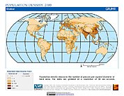
Global Rural-Urban Mapping Project, Version 1 (GRUMPv1): Population Density Grid
National Aeronautics and Space Administration —
The Global Rural-Urban Mapping Project, Version 1 (GRUMPv1): Population Density Grid estimates population per square km for the years 1990, 1995, and 2000 by 30 arc-...

Official websites use .gov
A
.gov website belongs to an official government
organization in the United States.
Secure .gov websites use HTTPS
A
lock (
) or https:// means you’ve safely connected to
the .gov website. Share sensitive information only on official,
secure websites.