
-
Federal
Gridded Population of the World, Version 3 (GPWv3): Population Density Grid
National Aeronautics and Space Administration —
The Gridded Population of the World, Version 3 (GPWv3): Population Density Grid consists of estimates of human population for the years 1990, 1995, and 2000 by 2.5... -
Federal
National Assessment of Oil and Gas Project - Permian Basin Province (044) Quarter-Mile Cells
Department of the Interior —
Cell maps for each oil and gas assessment unit were created by the USGS to illustrate the degree of exploration, type of production, and distribution of production in... -
Federal
Sentinel-5P TROPOMI Near-Real-Time (NRT) Tropospheric Ozone Column V2 (S5P_L2__O3_TCL_NRT) at GES DISC
National Aeronautics and Space Administration —
The Sentinel-5P TROPOMI Near Real Time (NRT) Tropospheric Ozone Column V2 (S5P_L2__O3_TCL_NRT) at GES DISC is the near real time version of the offline S5P_L2__O3_TCL... -
Federal
SWOT Level 2 KaRIn Low Rate Sea Surface Height Data Product, Version 2.0
National Aeronautics and Space Administration —
The SWOT Level 2 KaRIn Low Rate Sea Surface Height Data Product from the Surface Water Ocean Topography (SWOT) mission provides global sea surface height and... -
Federal
GTOPO30 Hydro 1K
National Aeronautics and Space Administration —
HYDRO1k is a geographic database developed to provide comprehensive and consistent global coverage of topographically derived data sets, including streams, drainage... -
Federal
National Assessment of Oil and Gas Project - Wind River Basin Province (035) Assessment Units Quarter-Mile Cells
Department of the Interior —
Cell maps for each oil and gas assessment unit were created by the USGS to illustrate the degree of exploration, type of production, and distribution of production in... -
Federal
IceBridge LVIS L2 Geolocated Surface Elevation Product V002
National Aeronautics and Space Administration —
This data set contains surface elevation data over parts of Greenland, measured by the NASA Land, Vegetation, and Ice Sensor (LVIS), an airborne lidar scanning laser... -
Federal
SMAPVEX08 In Situ Vegetation Data V001
National Aeronautics and Space Administration —
This data set includes in situ vegetation data collected during the Soil Moisture Active Passive Validation Experiment 2008 (SMAPVEX08) campaign. Sampling was... -
Federal
Aquarius L3 Gridded 1-Degree Seasonal Soil Moisture Climatology V005
National Aeronautics and Space Administration —
This data set contains Level-3 gridded seasonal global soil moisture climatology estimates derived from the NASA Aquarius passive microwave radiometer on the Satélite... -
Federal
Compendium of Environmental Sustainability Indicator Collections: 2004 Environmental Vulnerability Index (EVI)
National Aeronautics and Space Administration —
The 2004 Environmental Vulnerability Index (EVI) portion of the Compendium of Environmental Sustainability Indicator Collections contains 111 variables for 235... -
Federal
Gridded Population of the World, Version 3 (GPWv3): Centroids
National Aeronautics and Space Administration —
The Gridded Population of the World, Version 3 (GPWv3): Centroids consists of estimates of human population counts and densities for the years 1990, 1995, 2000, 2005,... -
Federal
Earth Resources Observation and Science (EROS) Center's Landsat State Mosaics Gallery
National Aeronautics and Space Administration —
The Earth Resources Observation and Science (EROS) Center manages the this gallery of images of the 50 U.S. states plus Puerto Rico as derived by Landsat data. -
Federal
CMS: Simulated Physical-Biogeochemical Data, SABGOM Model, Gulf of Mexico, 2005-2010
National Aeronautics and Space Administration —
This dataset contains monthly mean ocean surface physical and biogeochemical data for the Gulf of Mexico simulated by the South Atlantic Bight and Gulf of Mexico... -
Federal
VIIRS/NPP Vegetation Indices Monthly L3 Global 0.05Deg CMG V001
National Aeronautics and Space Administration —
The NASA/NOAA Suomi National Polar-orbiting Partnership (Suomi-NPP) Visible Infrared Imaging Radiometer Suite (VIIRS) Vegetation Indices (VNP13C2) Version 1 data... -
Federal
Suomi-NPP VIIRS Geolocation Product Data, version 2
National Aeronautics and Space Administration —
The Visible and Infrared Imager/Radiometer Suite (VIIRS) Geolocation (GEO) Products are data containing terrain corrected solar zenith and azimuth angles, satellite... -
Federal
Aqua MODIS Level-3 Global Mapped 11µm Nighttime Sea Surface Temperature (NSST) Data, version R2019.0 NGDA
National Aeronautics and Space Administration —
MODIS (or Moderate-Resolution Imaging Spectroradiometer) is a key instrument aboard the Terra (EOS AM) and Aqua (EOS PM) satellites. Terra's orbit around the Earth is... -
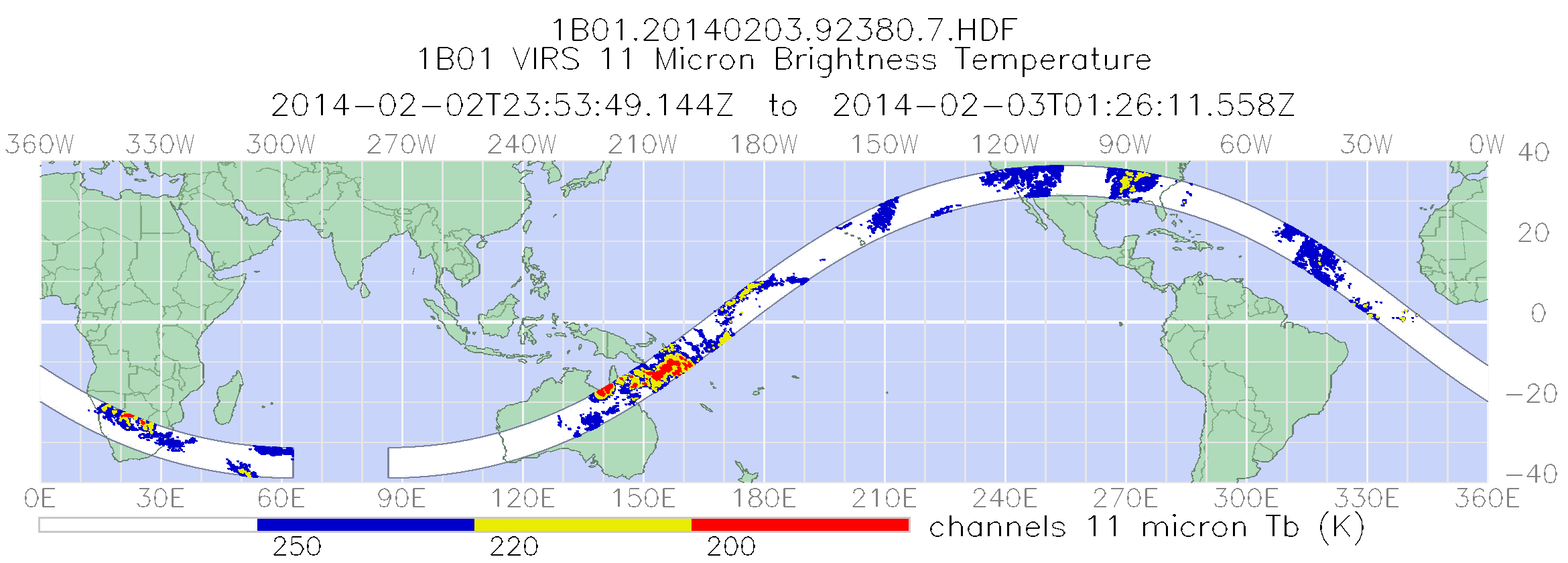
Federal
TRMM Visible and Infrared Scanner Calibrated Radiances L1B 1.5 hours V7 (TRMM_1B01) at GES DISC
National Aeronautics and Space Administration —
This TRMM Visible and Infrared Scanner (VIRS) Level 1B Calibrated Radiance Product (1B01) contains calibrated radiances and auxiliary geolocation information from the... -
Federal
IceBridge LVIS L1A Geotagged Images V001
National Aeronautics and Space Administration —
This data set contains geotagged images taken over Greenland and Antarctica by the NASA Digital Mapping Camera paired with the Land, Vegetation, and Ice Sensor... -
Federal
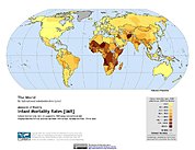
Poverty Mapping Project: Global Subnational Infant Mortality Rates
National Aeronautics and Space Administration —
The Poverty Mapping Project: Global Subnational Infant Mortality Rates data set consists of estimates of infant mortality rates for the year 2000. The infant...

Official websites use .gov
A
.gov website belongs to an official government
organization in the United States.
Secure .gov websites use HTTPS
A
lock (
) or https:// means you’ve safely connected to
the .gov website. Share sensitive information only on official,
secure websites.