
-
Federal
TIGER/Line Shapefile, 2021, County, Tom Green County, TX, All Roads
U.S. Census Bureau, Department of Commerce —
The TIGER/Line shapefiles and related database files (.dbf) are an extract of selected geographic and cartographic information from the U.S. Census Bureau's Master... -
Federal
TIGER/Line Shapefile, 2021, County, Polk County, TX, All Roads
U.S. Census Bureau, Department of Commerce —
The TIGER/Line shapefiles and related database files (.dbf) are an extract of selected geographic and cartographic information from the U.S. Census Bureau's Master... -
Federal
Jurassic evaporite facies of the Afghan-Tajik and Amu Darya basins in northern Afghanistan and adjacent areas (evapfacafg.shp)
Department of the Interior —
This shapefile contains polygons that describe the spatial extent of Jurassic age evaporite facies (Gaurdak formation) in the Afghan-Tajik and Amu Darya basins. -
Federal
National Assessment of Oil and Gas Quarter-Mile Cells - Cotton Valley Group and Travis Peak-Hosston Formations, Western Gulf and East Texas Basin and Louisiana-Mississippi Salt Basins Provinces (047, 048 and 049)
Department of the Interior —
Cell maps for each oil and gas assessment unit were created by the USGS as a method for illustrating the degree of exploration, type of production, and distribution... -
Federal
TIGER/Line Shapefile, 2022, State, Texas, Area Landmark
U.S. Census Bureau, Department of Commerce —
The TIGER/Line shapefiles and related database files (.dbf) are an extract of selected geographic and cartographic information from the U.S. Census Bureau's Master... -
Federal
TIGER/Line Shapefile, 2020, State, Texas, Voting Districts
U.S. Census Bureau, Department of Commerce —
The TIGER/Line shapefiles and related database files (.dbf) are an extract of selected geographic and cartographic information from the U.S. Census Bureau's Master... -
Federal
Faults in the Gulf Coast [gcfaultsg]
Department of the Interior —
These mapped faults are modified from Plate 2, Principal structural features, Gulf of Mexico Basin (compiled by T.E. Ewing and R.F. Lopez) in Volume J, The Geology of... -
Federal
2 Observations: Deep learning approaches for improving prediction of daily stream temperature in data-scarce, unmonitored, and dammed basins
Department of the Interior —
This data release component contains mean daily stream water temperature observations, retrieved from the USGS National Water Information System (NWIS) and used to... -
Federal
National Assessment of Oil and Gas Quarter-Mile Cells - Upper Cretaceous Taylor and Navarro Groups, Western Gulf Province (047)
Department of the Interior —
Cell maps for each oil and gas assessment unit were created by the USGS to illustrate the degree of exploration, type of production, and distribution of production in... -
Federal
TIGER/Line Shapefile, 2021, County, Jeff Davis County, TX, All Roads
U.S. Census Bureau, Department of Commerce —
The TIGER/Line shapefiles and related database files (.dbf) are an extract of selected geographic and cartographic information from the U.S. Census Bureau's Master... -
Federal
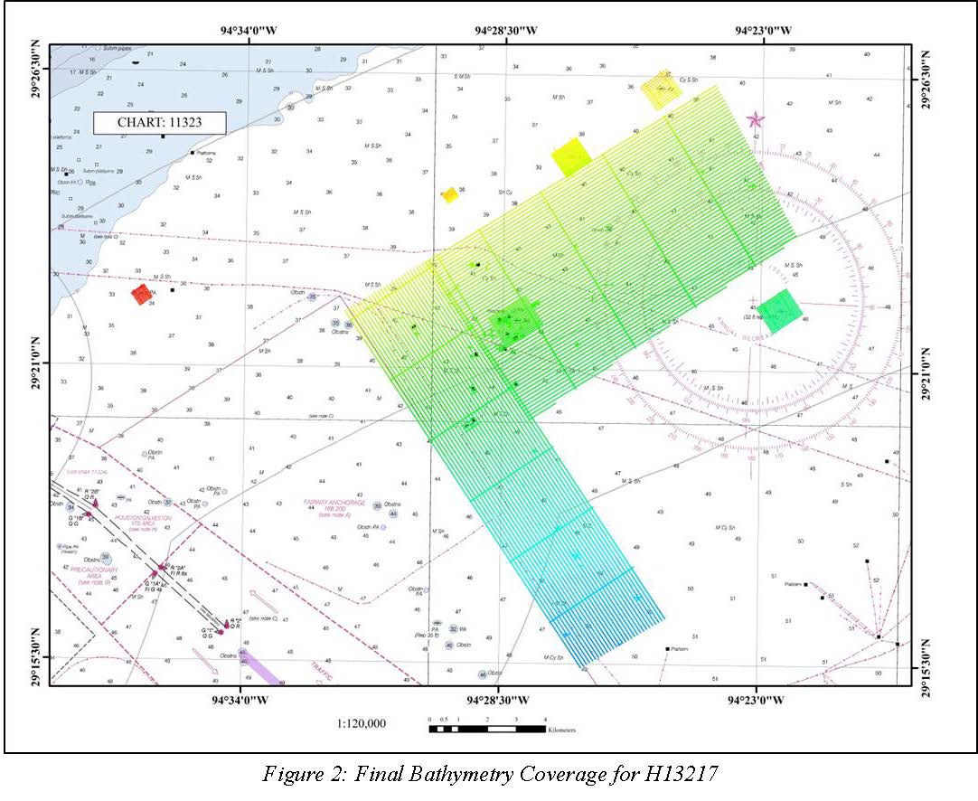
H13217: NOS Hydrographic Survey , 2019-09-20
National Oceanic and Atmospheric Administration, Department of Commerce —
The National Oceanic and Atmospheric Administration (NOAA) has the statutory mandate to collect hydrographic data in support of nautical chart compilation for safe... -
Federal
Shorelines of the Texas west (TXwest) coastal region used in shoreline change analysis
Department of the Interior —
Sandy ocean beaches are a popular recreational destination, often surrounded by communities containing valuable real estate. Development is on the rise despite the... -
Federal
TIGER/Line Shapefile, 2021, County, Travis County, TX, All Roads
U.S. Census Bureau, Department of Commerce —
The TIGER/Line shapefiles and related database files (.dbf) are an extract of selected geographic and cartographic information from the U.S. Census Bureau's Master... -
Federal
2022 Cartographic Boundary File (KML), Current County Subdivision for Texas, 1:500,000
U.S. Census Bureau, Department of Commerce —
The 2022 cartographic boundary KMLs are simplified representations of selected geographic areas from the U.S. Census Bureau's Master Address File / Topologically... -
Federal
National Assessment of Oil and Gas Project Bend Arch-Fort Worth Basin Province (045) Boundary
Department of the Interior —
The USGS Central Region Energy Team assesses oil and gas resources of the United States. The onshore and State water areas of the United States comprise 71 provinces.... -
Federal
TIGER/Line Shapefile, 2021, County, Hardin County, TX, All Roads
U.S. Census Bureau, Department of Commerce —
The TIGER/Line shapefiles and related database files (.dbf) are an extract of selected geographic and cartographic information from the U.S. Census Bureau's Master... -
Federal
H12763: NOS Hydrographic Survey , 2015-08-12
National Oceanic and Atmospheric Administration, Department of Commerce —
The National Oceanic and Atmospheric Administration (NOAA) has the statutory mandate to collect hydrographic data in support of nautical chart compilation for safe... -
Federal
Structure Contour of the Top of the Travis Peak-Hosston Formations, Western Gulf and East Texas Basin and Louisiana-Mississippi Salt Basins Provinces (047, 048 and 049)
Department of the Interior —
This map shows the structural configuration of the top of the Travis Peak or Hosston Formations in feet below sea level. The map was produced by calculating the... -
Federal
TIGER/Line Shapefile, 2021, County, Dickens County, TX, All Roads
U.S. Census Bureau, Department of Commerce —
The TIGER/Line shapefiles and related database files (.dbf) are an extract of selected geographic and cartographic information from the U.S. Census Bureau's Master... -
Federal
TIGER/Line Shapefile, 2022, State, Texas, Point Landmark
U.S. Census Bureau, Department of Commerce —
The TIGER/Line shapefiles and related database files (.dbf) are an extract of selected geographic and cartographic information from the U.S. Census Bureau's Master...

Official websites use .gov
A
.gov website belongs to an official government
organization in the United States.
Secure .gov websites use HTTPS
A
lock (
) or https:// means you’ve safely connected to
the .gov website. Share sensitive information only on official,
secure websites.