

404 datasets found
-
City
4.03 Water Conservation
City of Tempe —
This page provides information for the Water Conservation performance measure. -
City
Parks - Buildings - KML (deprecated November 2016)
City of Chicago —
Buildings located in Chicago parks. To view or use this KMZ file, compression software, such as 7-Zip, and special GIS software, such as Google Earth, are required.... -
City
Cook County - Forest Preserves Trails - Historical
City of Chicago —
This dataset is no longer maintained. For current geographic data about Cook County Forest Preserves, we recommend this site. Trails within the Forest Preserve... -
City
4.04 Solid Waste Landfill Diversion (summary)
City of Tempe —
This page provides data for the Solid Waste Landfill Diversion performance measure. The performance measure dashboard is available at 4.04 Solid Waste Landfill... -
City
Cook County - Forest Preserve Groves - Historical
City of Chicago —
This dataset is no longer maintained. For current geographic data about Cook County Forest Preserves, we recommend this site. Groves within the Forest Preserve... -
City
Energy Use for Water Treatment and Transportation
City of Bloomington —
Reduce the amount of energy it takes to treat and transport water. -
City
Public Schools - Environmental Justice Priority
City of Seattle —
This data layer references data from a high-resolution tree canopy change-detection layer for Seattle, Washington. Tree canopy change was mapped by using remotely... -
Federal
Natural Resource Protection and Child Health Indicators, 2019 Release
National Aeronautics and Space Administration —
The Natural Resource Protection and Child Health Indicators, 2019 Release, is produced in support of the U.S. Millennium Challenge Corporation (MCC) as selection... -
Federal
EnviroAtlas - Projected Change in Precipitation by 12-Digit HUC for Hawaii
U.S. Environmental Protection Agency —
This dataset was assembled using statistically downscaled climate projections from the NASA Earth Exchange-Global Daily Downscaled Projections (NEX-GDDP) project.... -
Federal
EnviroAtlas - Projected Change in Evapotranspiration by 12-Digit HUC for the U.S. Virgin Islands & Puerto Rico
U.S. Environmental Protection Agency —
This dataset was assembled using statistically downscaled climate projections from the NASA Earth Exchange-Global Daily Downscaled Projections (NEX-GDDP) project.... -
Federal
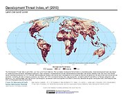
Development Threat Index
National Aeronautics and Space Administration —
The Development Threat Index data set is a terrestrial global, future development threat map based on combining these resources: agricultural expansion, urban... -
City
Bikeroutes3
City of Chicago —
OUTDATED. See the current data at https://data.cityofchicago.org/id/3w5d-sru8. -- Bike routes in Chicago. To view or use these files outside of a web brower,... -
City
Chicago Energy Benchmarking - Covered Buildings
City of Chicago —
The full list of buildings required to comply with the Chicago Energy Benchmarking Ordinance. As of 2016, this list includes all commercial, institutional, and... -
City
Boundaries - Recycling Service Areas - Shapefile (Deprecated March 2013)
City of Chicago —
Blue Cart Residential Recycling zones and schedule. Each recycling zone is divided into two sections – A (Orange) and B (Yellow). Collection is done on an... -
City
FY2023 Rated Projects in S.M.A.R.T. Housing Developments Measure
City of Austin —
Rated Projects in S.M.A.R.T. Housing Developments for fiscal year 2023. -
Federal
Coral Favorability: Non-Managed Conditions: Present - Guam
National Oceanic and Atmospheric Administration, Department of Commerce —
Many aspects of the environment are outside the control of local or regional resource managers. These conditions may require concerted global action to affect change... -
City
AEGB Rated Projects in S.M.A.R.T. Housing Developments Measure
City of Austin —
Rated Projects in S.M.A.R.T. Housing Developments since 2006 -
City
Public Schools - Possible TC - Vegetation (%)
City of Seattle —
This data layer references data from a high-resolution tree canopy change-detection layer for Seattle, Washington. Tree canopy change was mapped by using remotely... -
Federal
EnviroAtlas - Projected Change in Evapotranspiration by 12-Digit HUC for Guam and the Commonwealth of the Northern Mariana Islands
U.S. Environmental Protection Agency —
This dataset was assembled using statistically downscaled climate projections from the NASA Earth Exchange-Global Daily Downscaled Projections (NEX-GDDP) project....
404 datasets found