
-
Federal
2022 Cartographic Boundary File (SHP), Current Elementary School District for South Carolina, 1:500,000
U.S. Census Bureau, Department of Commerce —
The 2022 cartographic boundary shapefiles are simplified representations of selected geographic areas from the U.S. Census Bureau's Master Address File /... -
Federal
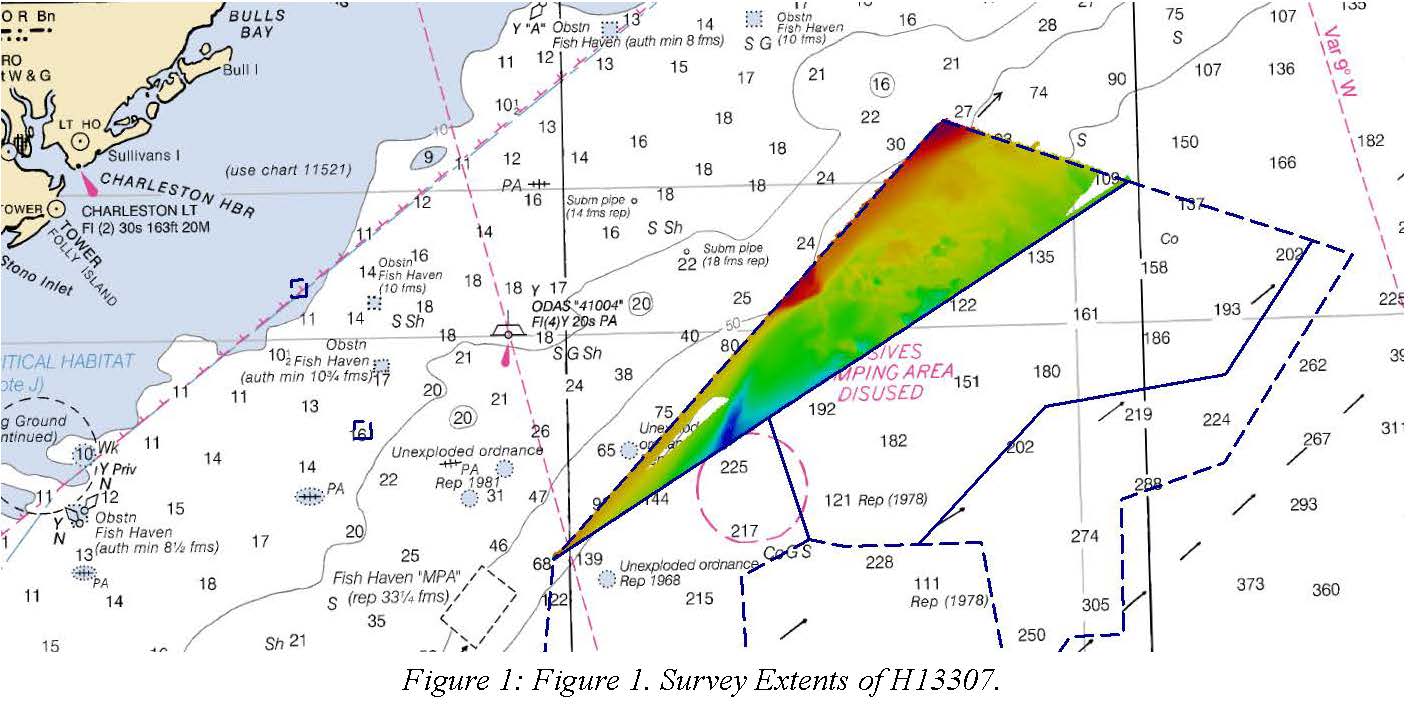
H13307: NOS Hydrographic Survey , 2019-08-30
National Oceanic and Atmospheric Administration, Department of Commerce —
The National Oceanic and Atmospheric Administration (NOAA) has the statutory mandate to collect hydrographic data in support of nautical chart compilation for safe... -
Federal
Cowpens National Battlefield Small-Scale Base GIS Data
Department of the Interior —
This data set contains small-scale base GIS data layers compiled by the National Park Service Servicewide Inventory and Monitoring Program and Water Resources... -
Federal
2023 Cartographic Boundary File (KML), 118th Congressional Districts for South Carolina, 1:500,000
U.S. Census Bureau, Department of Commerce —
The 2023 cartographic boundary KMLs are simplified representations of selected geographic areas from the U.S. Census Bureau's Master Address File / Topologically... -
Federal
TIGER/Line Shapefile, 2021, State, South Carolina, 2020 Census Blocks
U.S. Census Bureau, Department of Commerce —
The TIGER/Line shapefiles and related database files (.dbf) are an extract of selected geographic and cartographic information from the U.S. Census Bureau's Master... -
Federal
TIGER/Line Shapefile, 2021, County, Sumter County, SC, All Roads
U.S. Census Bureau, Department of Commerce —
The TIGER/Line shapefiles and related database files (.dbf) are an extract of selected geographic and cartographic information from the U.S. Census Bureau's Master... -
Federal
TIGER/Line Shapefile, 2022, State, South Carolina, SC, Unified School Districts
U.S. Census Bureau, Department of Commerce —
The TIGER/Line shapefiles and related database files (.dbf) are an extract of selected geographic and cartographic information from the U.S. Census Bureau's Master... -
Federal
TIGER/Line Shapefile, 2021, County, Newberry County, SC, All Roads
U.S. Census Bureau, Department of Commerce —
The TIGER/Line shapefiles and related database files (.dbf) are an extract of selected geographic and cartographic information from the U.S. Census Bureau's Master... -
Federal
TIGER/Line Shapefile, 2021, County, Clarendon County, SC, All Roads
U.S. Census Bureau, Department of Commerce —
The TIGER/Line shapefiles and related database files (.dbf) are an extract of selected geographic and cartographic information from the U.S. Census Bureau's Master... -
Federal
2024 Cartographic Boundary File (SHP), Secondary School District for South Carolina, 1:500,000
U.S. Census Bureau, Department of Commerce —
The 2024 cartographic boundary shapefiles are simplified representations of selected geographic areas from the U.S. Census Bureau's Master Address File /... -
Federal
Ninety Six National Historic Site Small-Scale Base GIS Data
Department of the Interior —
This data set contains small-scale base GIS data layers compiled by the National Park Service Servicewide Inventory and Monitoring Program and Water Resources... -
Federal
Airborne geophysical survey: North-central South Carolina, South Carolina
Department of the Interior —
Aeromagnetic data were collected along flight lines by instruments in an aircraft that recorded magnetic-field values and locations. This dataset presents latitude,... -
Federal
Digital Shoreline Analysis System version 4.3 Transects with Short-Term Linear Regression Rate Calculations for South Carolina (SC)
Department of the Interior —
Sandy ocean beaches are a popular recreational destination, often surrounded by communities containing valuable real estate. Development is on the rise despite the... -
Federal
Airborne geophysical survey: South Carolina-Georgia Border, South Carolina
Department of the Interior —
Aeromagnetic data were collected along flight lines by instruments in an aircraft that recorded magnetic-field values and locations. This dataset presents latitude,... -
Federal
TIGER/Line Shapefile, 2024, State, South Carolina, SC, 119th Congressional District
U.S. Census Bureau, Department of Commerce —
The TIGER/Line shapefiles and related database files (.dbf) are an extract of selected geographic and cartographic information from the U.S. Census Bureau's Master... -
Federal
TIGER/Line Shapefile, 2024, State, South Carolina, SC, Elementary School Districts
U.S. Census Bureau, Department of Commerce —
The TIGER/Line shapefiles and related database files (.dbf) are an extract of selected geographic and cartographic information from the U.S. Census Bureau's Master... -
Federal
TIGER/Line Shapefile, Current, State, South Carolina, State Legislative District (SLD) Upper Chamber
U.S. Census Bureau, Department of Commerce —
This resource is a member of a series. The TIGER/Line shapefiles and related database files (.dbf) are an extract of selected geographic and cartographic information... -
Federal
Deepwater Canyons 2012: Pathways to the Abyss on NOAA Ship Nancy Foster between 20120815 and 20121001
National Oceanic and Atmospheric Administration, Department of Commerce —
The Mid-Atlantic Deep-Water Canyons project is co-funded by the Bureau of Ocean Energy Management (BOEM) and NOAAâs Office of Ocean Exploration and Research (which... -
Federal
H13983: NOS Hydrographic Survey , 2024-10-13
National Oceanic and Atmospheric Administration, Department of Commerce —
The National Oceanic and Atmospheric Administration (NOAA) has the statutory mandate to collect hydrographic data in support of nautical chart compilation for safe... -
Federal
BLM ES Administrative Unit Office Arc
Department of the Interior —
This polyline feature class represents the spatial extent of active Bureau of Land Management (BLM) Administrative Unit Boundaries at the State, District, and Field...

Official websites use .gov
A
.gov website belongs to an official government
organization in the United States.
Secure .gov websites use HTTPS
A
lock (
) or https:// means you’ve safely connected to
the .gov website. Share sensitive information only on official,
secure websites.