
-
Federal
CERES MODIS Cloud Retrievals in ISCCP-D2like Format Day Terra FM2 Edition3A NGDA
National Aeronautics and Space Administration —
CER_ISCCP-D2like-Day_Terra-FM2-MODIS_Edition3A is the Clouds and the Earth's Radiant Energy System (CERES) Moderate Resolution Imaging Spectroradiometer (MODIS) Cloud... -
Federal
Fast Longwave And SHortwave Fluxes (FLASHflux) Clouds and Radiative Swath (SSF) TERRA-FM1 data in netCDF Version 4B
National Aeronautics and Space Administration —
FLASH_SSF_Terra-FM1-MODIS_Version4B is the Fast Longwave And Shortwave Radiative Fluxes (FLASHFlux) Clouds and Radiative Swath (SSF) TERRA-FM1 data in netCDF Version... -
Federal
US Voluntary Observing Ship (VOS) - International Maritime Meteorological Tape (IMMT) data from TurboWin+ E-Logbook Software
National Oceanic and Atmospheric Administration, Department of Commerce —
The US Voluntary Observing Ships (VOS) report surface marine observations in both real-time (FM-13 ship format) and delayed-mode (International Maritime... -
Federal
TOVS GLA MONTHLY GRIDS from NOAA-11 V01 (TOVSAMNH) at GES DISC
National Aeronautics and Space Administration —
This dataset (TOVSAMNH) contains the TIROS Operational Vertical Sounder (TOVS) level 3 geophysical parameters derived using data from NOAA-11 and the physical... -
Federal
Sentinel-5P TROPOMI SNPP VIIRS cloud product band 3 (UVIS detector) 1-Orbit L2 5.5km x 3.5km V1 (S5P_L2__NP_BD3_HiR) at GES DISC
National Aeronautics and Space Administration —
Starting from August 6th in 2019, Sentinel-5P TROPOMI along-track high spatial resolution (~5.5km at nadir) has been implemented. For data before August 6th of 2019,... -
Federal
AMSR-E/AMSR2 Unified L3 Global Weekly Ascending/Descending .25x.25 deg Ocean Grids V001
National Aeronautics and Space Administration —
The AMSR-E/AMSR2 Unified L3 Global Weekly Ascending/Descending .25 x .25 deg Ocean Grids data set (AU_WkOcn) reports weekly estimates of water vapor, cloud liquid... -
Federal
NOAA GOES-R Series Advanced Baseline Imager (ABI) Level 2 Cloud Top Pressure (CTP)
National Oceanic and Atmospheric Administration, Department of Commerce —
The Advanced Baseline Imager (ABI) Cloud Top Pressure product contains an image with pixel values identifying the atmospheric pressure at the top of a cloud layer.... -
Federal
AMSR-E/AMSR2 Unified L3 Global Daily Ascending/Descending .25x.25 deg Ocean Grids V001
National Aeronautics and Space Administration —
The AMSR-E/AMSR2 Unified L3 Global Daily Ascending/Descending .25 x .25 deg Ocean Grids data set (AU_DyOcn) reports daily estimates of water vapor, cloud liquid water... -
Federal
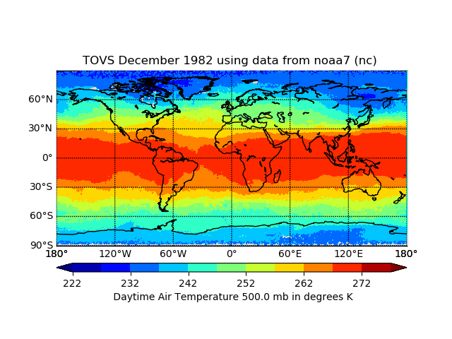
TOVS GLA MONTHLY GRIDS from NOAA-7 02 (TOVSAMNC) at GES DISC
National Aeronautics and Space Administration —
This dataset (TOVSAMNC) contains the TIROS Operational Vertical Sounder (TOVS) level 3 geophysical parameters derived using data from NOAA-7 and the physical... -
Federal
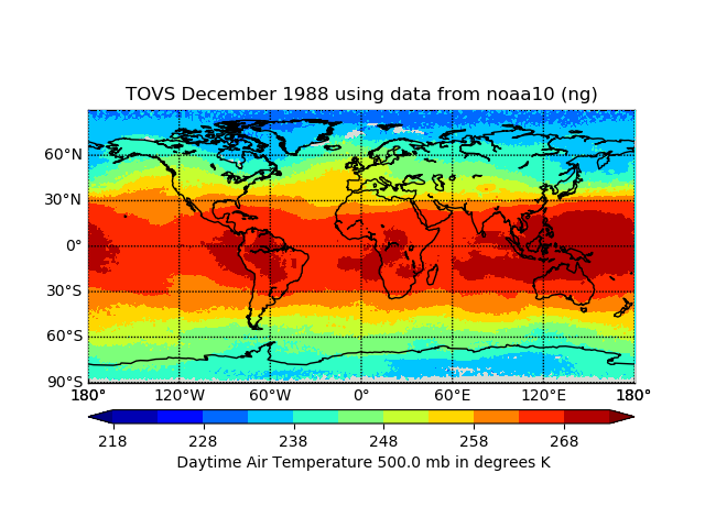
TOVS GLA MONTHLY GRIDS from NOAA-10 02 (TOVSAMNG) at GES DISC
National Aeronautics and Space Administration —
This dataset (TOVSAMNG) contains the TIROS Operational Vertical Sounder (TOVS) level 3 geophysical parameters derived using data from NOAA-10 and the physical... -
Federal
NOAA Climate Data Record (CDR) of Advanced Microwave Sounding Unit (AMSU)-A Brightness Temperature, Version 1
National Oceanic and Atmospheric Administration, Department of Commerce —
The NOAA Climate Data Record (CDR) for Advanced Microwave Sounding Unit-A (AMSU-A) brightness temperature in "window channels". The data cover a time period from 1998... -
Federal
TOVS GLA MONTHLY GRIDS from NOAA-10 V01 (TOVSAMNG) at GES DISC
National Aeronautics and Space Administration —
This dataset (TOVSAMNG) contains the TIROS Operational Vertical Sounder (TOVS) level 3 geophysical parameters derived using data from NOAA-10 and the physical... -
Federal
Sounder SIPS: Suomi NPP CrIMSS Level 2 CLIMCAPS Full Spectral Resolution: Atmosphere cloud and surface geophysical state V2 at GES DISC
National Aeronautics and Space Administration —
The CLIMCAPS (Community Long-term Infrared Microwave Coupled Product System) algorithm is used to analyze data from the Cross-track Infrared Sounder/Advanced... -
Federal
TOVS GLA 5 DAY GRIDS from NOAA-10 V01 (TOVSA5NG) at GES DISC
National Aeronautics and Space Administration —
This dataset (TOVSA5NG) contains the TIROS Operational Vertical Sounder (TOVS) level 3 geophysical parameters derived using data from NOAA-10 and the physical... -
Federal
Defense Meteorological Satellite Program (DMSP) Film
National Oceanic and Atmospheric Administration, Department of Commerce —
The United States Air Force Defense Meteorological Satellite Program (DMSP) Operational Linescan System (OLS) is a polar orbiting meteorological sensor with two... -
Federal
SWOT Level 2 Radiometer Brightness Temperatures and Troposphere Operational Data Product Version 1.0
National Aeronautics and Space Administration —
The SWOT Level 2 Radiometer Brightness Temperatures and Troposphere Operational Geophysical Data Record (OGDR) Version 1.0 dataset produced by the Surface Water and... -
Federal
TOVS GLA MONTHLY GRIDS from NOAA-11 V01 (TOVSAMNH) at GES DISC
National Aeronautics and Space Administration —
This dataset (TOVSAMNH) contains the TIROS Operational Vertical Sounder (TOVS) level 3 geophysical parameters derived using data from NOAA-11 and the physical... -
Federal
TES/Aura L2 Carbon Dioxide Nadir V007
National Aeronautics and Space Administration —
TL2CO2N_7 is the Tropospheric Emission Spectrometer (TES)/Aura Level 2 Carbon Dioxide Nadir Version 7 data product. TES was an instrument aboard NASA's Aura satellite... -
Federal
NOAA GOES-R Series Advanced Baseline Imager (ABI) Level 2 Cloud Cover Layers (CCL)
National Oceanic and Atmospheric Administration, Department of Commerce —
The GOES-R Advanced Baseline Imager (ABI) Cloud Cover Layers (CCL) product contains estimates of cloud fraction between predefined atmospheric levels, as well as, the...

Official websites use .gov
A
.gov website belongs to an official government
organization in the United States.
Secure .gov websites use HTTPS
A
lock (
) or https:// means you’ve safely connected to
the .gov website. Share sensitive information only on official,
secure websites.