
-
Federal
Earth Resources Observation and Science (EROS) Center's Journey of Lewis and Clark Gallery
National Aeronautics and Space Administration —
The Earth Resources Observation and Science (EROS) Center manages the this gallery of Landsat-derived images of one of the most remarkable and productive scientific... -
Federal
UARS Cryogenic Limb Array Etalon Spectrometer (CLAES) Level 3AL V009 (UARCL3AL) at GES DISC
National Aeronautics and Space Administration —
The Cryogenic Limb Array Etalon Spectrometer (CLAES) Level 3AL data product consists of daily, 4 degree increment latitude-ordered vertical profiles of temperature... -
Federal
ABoVE: Landsat-derived Annual Dominant Land Cover in Boreal North America, 1986-2020
National Aeronautics and Space Administration —
This dataset contains a 30-m resolution time series of annual land cover classifications as the dominant plant functional type class for all of boreal Alaska and... -
Federal
TES/Aura L2 Methanol Lite Nadir V006
National Aeronautics and Space Administration —
Atmospheric vertical profile estimates and associated errors including the mapping matrix to relate the reduced-size retrieval vectors, covariances, and averaging... -
Federal
AMSR-E/AMSR2 Unified L3 Global 5-Day 25 km EASE-Grid Snow Water Equivalent V001
National Aeronautics and Space Administration —
This AMSR-E/AMSR2 Unified Level-3 (L3) data set provides 5-day maximum estimates of Snow Water Equivalent (SWE). SWE was derived from brightness temperature... -
Federal
AMSR-E/Aqua Monthly L3 5x5 deg Rainfall Accumulations V002
National Aeronautics and Space Administration —
This Level-3 rainfall accumulation product (AE_RnGd) consists of two grids of 28 rows by 72 columns of monthly averaged rainfall accumulation over ocean and land.... -
Federal
National Assessment of Oil and Gas Project - Black Warrior Basin Province (065) Total Petroleum Systems
Department of the Interior —
The Total Petroleum System is used in the National Assessment Project and incorporates the Assessment Unit, which is the fundamental geologic unit used for the... -
Federal
SMAPVEX19-22 Millbrook UAVSAR Mosaics V001
National Aeronautics and Space Administration —
This data set consists of mosaicked Uninhabited Aerial Vehicle Synthetic Aperture Radar (UAVSAR) images corrected for terrain-flattened gamma. Data image files at... -
Federal
Nimbus-7 Narrow Field of View (NFOV) Maximum Likelihood Cloud Estimation (MLCE) Data in Native Format
National Aeronautics and Space Administration —
NIMBUS7_NFOV_MLCE data are Nimbus 7 Narrow Field of View (NFOV) Maximum Likelihood Cloud Estimation (MLCE) Data in Native Format.The NIMBUS7_NFOV_MLCE data set uses... -
Federal
National Assessment of Oil and Gas Project - Hanna, Laramie, Shirley Basins Province (030) Total Petroleum Systems
Department of the Interior —
The Total Petroleum System is used in the National Assessment Project and incorporates the Assessment Unit, which is the fundamental geologic unit used for the... -
Federal
VIIRS/JPSS1 Ice Surface Temperature Daily L3 Global 750m EASE-Grid 2.0 Night V002
National Aeronautics and Space Administration —
This data set reports sea ice surface temperature (IST) derived from radiance data acquired by the Visible Infrared Imager Radiometer Suite (VIIRS). Following the... -
Federal
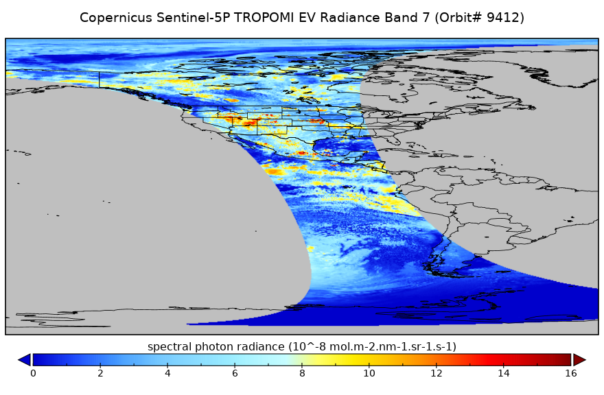
Sentinel-5P TROPOMI Radiance product band 7 (SWIR detector) L1B 5.5km x 7km V2 (S5P_L1B_RA_BD7_HiR) at GES DISC
National Aeronautics and Space Administration —
Starting from August 6th in 2019, Sentinel-5P TROPOMI along-track high spatial resolution (~5.5km at nadir) has been implemented. For data before August 6th of 2019,... -
Federal
SMAP_L1A_RADAR_RECEIVE_ONLY_QA_V001
National Aeronautics and Space Administration —
SMAP Level 1A Radar Receive Only Data Quality Information Version 1 -
Federal
ABoVE: Seasonal Dissolved Gases and Isotopes in Arctic Alaska Rivers
National Aeronautics and Space Administration —
This dataset provides dissolved carbon dioxide (CO2) and methane (CH4) concentrations alongside their stable and radiocarbon isotopic compositions within the Arctic... -
Federal
Sentinel-5P TROPOMI Aerosol Layer Height 1-Orbit L2 7km x 3.5km V1 (S5P_L2__AER_LH) at GES DISC
National Aeronautics and Space Administration —
Starting from August 6th in 2019, Sentinel-5P TROPOMI along-track high spatial resolution (~5.5km at nadir) has been implemented. For data after August 6th of 2019,... -
Federal
Turbulent Air Motion Measurement System (TAMMS) IMPACTS V1
National Aeronautics and Space Administration —
The Turbulent Air Motion Measurement System (TAMMS) IMPACTS dataset consists of wind speed, wind direction, and cross wind speed measurements from the TAMMS... -
Federal
U-Pb Ages, Hafnium Isotope Ratios, and Trace Element Concentrations by Laser-Ablation Split Stream (LASS) Analysis of Igneous Zircons from the Western Alaska Range
Department of the Interior —
This dataset contains U-Pb isotopic data and ages, Hf isotope data, and trace element concentrations of zircon from igneous rocks collected from the western Alaska... -
Federal
ABoVE LVIS L2 Geolocated Surface Elevation Product V001
National Aeronautics and Space Administration —
This data set contains surface elevation data over Alaska and Western Canada measured by the NASA Land, Vegetation, and Ice Sensor (LVIS), an airborne lidar scanning... -
Federal
AIRSAR_TOPSAR_DEM_C
National Aeronautics and Space Administration —
AIRSAR topographic SAR digital elevation model CTIF product -
Federal
National Geologic Carbon Dioxide (CO2) Sequestration Assessment Project: Bighorn Basin (C5034) Well Density
Department of the Interior —
Drilling-density cell maps show the number of wells that have been drilled into the storage assessment unit (SAU). Each 1-square-mile cell has a count for the number...

Official websites use .gov
A
.gov website belongs to an official government
organization in the United States.
Secure .gov websites use HTTPS
A
lock (
) or https:// means you’ve safely connected to
the .gov website. Share sensitive information only on official,
secure websites.