
-
Federal
TES/Aura L2 Formic Acid Nadir Special Observation V007
National Aeronautics and Space Administration —
TL2FORNS_7 is the Tropospheric Emission Spectrometer (TES)/Aura Level 2 Formic Acid Nadir Special Observation Version 7 data product. It consists of information for... -
Federal
UARS Improved Stratospheric and Mesospheric Sounder (ISAMS) Level 3AL V010 (UARIS3AL) at GES DISC
National Aeronautics and Space Administration —
The Improved Stratospheric and Mesospheric Sounder (ISAMS) Level 3AL data product consists of daily, 4 degree increment latitude-ordered vertical profiles of... -
Federal
TIN Dataset Model of Overburden Above the Mahogany Zone in the Piceance Basin, Colorado
Department of the Interior —
An ESRI TIN data model of the overburden material above the Mahogany Zone was needed to perform calculations in the Piceance Basin, Colorado as part of a 2009... -
Federal
TES/Aura L2 Ozone Nadir Special Observation V007
National Aeronautics and Space Administration —
TL2O3NS_7 is the Tropospheric Emission Spectrometer (TES)/Aura Level 2 Ozone Nadir Special Observation Version 7 data product. TES was an instrument aboard NASA's... -
Federal
Post-wildfire debris-flow monitoring data, 2014 Silverado Fire, Orange County, California, November 2014 to January 2016.
Department of the Interior —
This data release includes time-series data from two monitoring stations in a small drainage basin burned in the 2014 Silverado Fire, Orange County, California. One... -
Federal
SMAP L4 Global Daily 9 km EASE-Grid Carbon Net Ecosystem Exchange V007 NGDA
National Aeronautics and Space Administration —
The Level-4 (L4) carbon product (SPL4CMDL) provides global gridded daily estimates of net ecosystem carbon (CO2) exchange derived using a satellite data based... -
Federal
Earth+
National Aeronautics and Space Administration —
Earth+ makes NASA satellite photos and data accessible to blind students. -
Federal
OMPS-NPP L2 NM Aerosol Index swath orbital NRT
National Aeronautics and Space Administration —
The OMPS-NPP L2 NM Aerosol Index swath orbital V2 for Near Real Time. For the standard product see the OMPS_NPP_NMMIEAI_L2 product in CMR .The aerosol index is... -
Federal
Aquarius L3 Weekly Polar-Gridded Landscape Freeze/Thaw Data V005
National Aeronautics and Space Administration —
This Level-3 (L3) data set includes weekly Northern Hemisphere landscape freeze/thaw (FT) data derived from L-band radiometer brightness temperature observations,... -
Federal
IPCC Special Report on Emissions Scenarios (SRES) Fluor-Gases Emissions Dataset
National Aeronautics and Space Administration —
The Intergovernmental Panel on Climate Change (IPCC) Special Report Emissions Scenarios (SRES) Fluor-Gases Emissions Dataset consists of global and regional emissions... -
Federal
National Assessment of Oil and Gas Project - East Coast Mesozoic Basins of the Piedmont, Blue Ridge Thrust Belt, Atlantic Coastal Plain, and New England Provinces Assessment Units
Department of the Interior —
The Assessment Unit is the fundamental unit used in the National Assessment Project for the assessment of undiscovered oil and gas resources. The Assessment Unit is... -
Federal
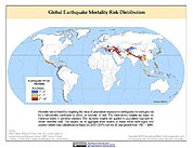
Global Earthquake Mortality Risks and Distribution
National Aeronautics and Space Administration —
The Global Earthquake Mortality Risks and Distribution is a 2.5 minute grid of global earthquake mortality risks. Gridded Population of the World, Version 3 (GPWv3)... -
Federal
NOAA-20 VIIRS Global Mapped Normalized Difference Vegetation Index Land Reflectance Data, version R2022.0
National Aeronautics and Space Administration —
The Visible and Infrared Imager/Radiometer Suite (VIIRS) is a multi-disciplinary instrument that is being flown on the Joint Polar Satellite System (JPSS) series of... -
Federal
Global One-Eighth Degree Urban Land Extent Projection and Base Year Grids by SSP Scenarios, 2000-2100
National Aeronautics and Space Administration —
The Global One-Eighth Degree Urban Land Extent Projection and Base Year Grids by SSP Scenarios, 2000-2100 consists of global SSP-consistent spatial urban land... -
Federal
National Assessment of Oil and Gas Project - Appalachian Basin (067) Quarter-Mile Cells
Department of the Interior —
Cell maps for each oil and gas assessment unit were created by the USGS as a method for illustrating the degree of exploration, type of production, and distribution... -
Federal
ACT-America: L1 Meteorological and Aircraft Navigational Data
National Aeronautics and Space Administration —
This dataset provides aircraft navigational parameters and related meteorological data (often referred to as "housekeeping" data) in support of the research... -
Federal
ARC Code TI: Geometry Manipulation Protocol (GMP)
National Aeronautics and Space Administration —
The Geometry Manipulation Protocol (GMP) is a library which serializes datatypes between XML and ANSI C data structures to support CFD applications. This library... -
Federal
TES/Aura L2 Water Vapor Nadir Special Observation V007
National Aeronautics and Space Administration —
TL2H2ONS_7 is the Tropospheric Emission Spectrometer (TES)/Aura Level 2 Water Vapor Nadir Special Observation Version 7 data product. It consists of information for... -
Federal
AMSR/ADEOS-II L2A Global Swath Spatially-Resampled Brightness Temperatures V001
National Aeronautics and Space Administration —
The AMSR Level-2A product (AA_L2A) contains brightness temperatures at 6.9 GHz, 10.65 GHz, 18.7 GHz, 23.8 GHz, 36.5 GHz, 89.0 GHz, 50.3 GHz, and 52.8GHz. Data are... -
Federal
TOVS GLA 5 DAY GRIDS from NOAA-11 V01 (TOVSA5NH) at GES DISC
National Aeronautics and Space Administration —
This dataset (TOVSA5NH) contains the TIROS Operational Vertical Sounder (TOVS) level 3 geophysical parameters derived using data from NOAA-11 and the physical...

Official websites use .gov
A
.gov website belongs to an official government
organization in the United States.
Secure .gov websites use HTTPS
A
lock (
) or https:// means you’ve safely connected to
the .gov website. Share sensitive information only on official,
secure websites.