
-
Federal
Reefs for the future: Resilience of coral reefs in the main Hawaiian Islands
National Oceanic and Atmospheric Administration, Department of Commerce —
Declining health of coral reef ecosystems led scientists to search for factors that support reef resilience: the ability of reefs to resist and recover from... -
Federal
SWOT Level 2 KaRIn Low Rate Sea Surface Height Data Product - Expert, Version 2.0
National Aeronautics and Space Administration —
The SWOT Level 2 KaRIn Low Rate Sea Surface Height Expert Data Product from the Surface Water Ocean Topography (SWOT) mission provides global sea surface height and... -
Federal
SODA - POP 2.2.4 Monthly Means, 1871-2010 (At Depths)
National Oceanic and Atmospheric Administration, Department of Commerce —
Simple Ocean Data Assimilation (SODA) version 2.2.4 - A reanalysis of ocean climate. SODA uses the GFDL modular ocean model version 2.2. The model is forced by... -
Federal
Digital Elevation Model of the Gulf of Mexico, Integrating Bathymetric and Topographic Datasets
National Oceanic and Atmospheric Administration, Department of Commerce —
Modeling and mapping of coastal processes (e.g. tsunamis, hurricane storm-surge, and sea-level rise) requires digital representations of Earth's solid surface,... -
Federal
Columbia River, WA/OR (P260) Bathymetric Digital Elevation Model (30 meter resolution) Derived From Source Hydrographic Survey Soundings Collected by NOAA
National Oceanic and Atmospheric Administration, Department of Commerce —
Bathymetry for the Columbia River was derived from forty-five surveys containing 306,711 soundings. Nine older, overlapping, less accurate surveys were omitted before... -
Federal
Hurricane Hugo Poster (September 21, 1989)
National Oceanic and Atmospheric Administration, Department of Commerce —
Hurricane Hugo poster. Multi-spectral image from NOAA-11 captures Hurricane Hugo slamming into South Carolina coast on September 21, 1989. Poster size is 36"x36". -
Federal
F00757: NOS Hydrographic Survey , 2018-11-01
National Oceanic and Atmospheric Administration, Department of Commerce —
The National Oceanic and Atmospheric Administration (NOAA) has the statutory mandate to collect hydrographic data in support of nautical chart compilation for safe... -
Federal
CRED Reson 8101 multibeam backscatter data from the banktop and bank edge environments of Ofu, Olosega, and Ta'u Islands of the Manua Island group, American Samoa with 1 meter resolution in netCDF format
National Oceanic and Atmospheric Administration, Department of Commerce —
Multibeam backscatter imagery extracted from gridded bathymetry of Ofu, Olosega, and Ta'u Islands of the Manua Island Group, American Samoa, South Pacific. These data... -
Federal
Kawaihae, Hawaii Tsunami Forecast Grids for MOST Model
National Oceanic and Atmospheric Administration, Department of Commerce —
The Kawaihae, Hawaii Forecast Model Grids provides bathymetric data strictly for tsunami inundation modeling with the Method of Splitting Tsunami (MOST) model. MOST... -
Federal
D00239: NOS Hydrographic Survey , 2017-09-15
National Oceanic and Atmospheric Administration, Department of Commerce —
The National Oceanic and Atmospheric Administration (NOAA) has the statutory mandate to collect hydrographic data in support of nautical chart compilation for safe... -
Federal
FAST Eddy Sys 4 Transect 22, 150kHz kHz VMADCP
National Oceanic and Atmospheric Administration, Department of Commerce —
Program of vessel mount ADCP measurements comprising a combination of 75kHz and 150kHz ADCP data collected in the vicinity of the Loop Current and drilling blocks... -
Federal
Continuously Updated Digital Elevation Model (CUDEM) - 1/3 Arc-Second Resolution Bathymetric-Topographic Tiles NGDA
National Oceanic and Atmospheric Administration, Department of Commerce —
NOAA's National Centers for Environmental Information (NCEI) is developing a suite of digital elevation models (DEMs) for the U.S. coast to support a variety of NOAA... -
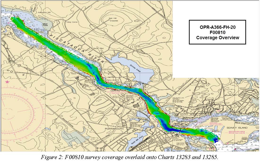
Federal
F00810: NOS Hydrographic Survey , 2020-08-05
National Oceanic and Atmospheric Administration, Department of Commerce —
The National Oceanic and Atmospheric Administration (NOAA) has the statutory mandate to collect hydrographic data in support of nautical chart compilation for safe... -
Federal
2025 SCDVA Lidar: Charleston County, SC
National Oceanic and Atmospheric Administration, Department of Commerce —
BERKELEY, CHARLESTON, ORANGEBURG LIDAR DATA COLLECTION Lidar Data Acquisition and Processing Production Task - Charleston County Contract Number: 6004 RFQ Number:... -
Federal
Coastal Bathymetry Data Collected in 2016 from the Chandeleur Islands, Louisiana–Single Beam Bathymetry Soundings (XYZ)
Department of the Interior —
The U.S. Geological Survey St. Petersburg Coastal and Marine Science Center (USGS SPCMSC), collected single beam and swath bathymetry data from the northern... -
Federal
2004 Landfalling Hurricanes Poster
National Oceanic and Atmospheric Administration, Department of Commerce —
The 2004 U.S. Landfalling Hurricanes poster is a special edition poster which contains two sets of images of Hurricanes Charley, Frances, Ivan, and Jeanne, created... -
Federal
Coastal Single-beam Bathymetry Data Collected in August 2018 from the Chandeleur Islands, Louisiana
Department of the Interior —
Scientists from the U.S. Geological Survey St. Petersburg Coastal and Marine Science Center (USGS - SPCMSC) in St. Petersburg, Florida, conducted a single-beam... -
Federal
CO-OPS station 8761927: USCG NEW CANAL STA., LAKE PONTCHARTRAIN 1-minute Raw Tsunami Water Level Data
National Oceanic and Atmospheric Administration, Department of Commerce —
CO-OPS has been involved with tsunami warning and mitigation since the Coast and Geodetic Survey started the Tsunami Warning System in 1948 to provide warnings to the... -
Federal
"NEGOM CTD - n9l11s16.nc - 27.5N, 85.23W - 2000-00-07"
National Oceanic and Atmospheric Administration, Department of Commerce —
The Northeastern Gulf of Mexico Physical Oceanography Program (NEGOM) is supported by the Minerals Management Service (MMS) of the U.S. Department of the Interior.... -
Federal
Walton-Smith CTD, WS15264, WS15264_WS15264sta41, 2015-09-23, 25.7333N 81.575W
National Oceanic and Atmospheric Administration, Department of Commerce —
Walton-Smith Conductivity, Temperature, Depth (CTD) - WS15264 - WS15264_WS15264sta41 - 2015-09-23 - 25.7333N 81.575W. Hydrographic Measurements in the Gulf of Mexico....

Official websites use .gov
A
.gov website belongs to an official government
organization in the United States.
Secure .gov websites use HTTPS
A
lock (
) or https:// means you’ve safely connected to
the .gov website. Share sensitive information only on official,
secure websites.