
-
Federal
Oil Shale Core Hole and Rotary Hole Locations in the State of Utah and Colorado
Department of the Interior —
This file contains points that describe locations of oil shale core holes, rotary holes, and surface sections in the state of Utah and is available as an ESRI... -
Federal
Estimated Thickness of the Cotton Valley Group to the Top of the Smackover Formation, Western Gulf and East Texas Basin and Louisiana-Mississippi Salt Basins Provinces (047, 048 and 049)
Department of the Interior —
This isopach map shows the thickness of the interval from the top of the Cotton Valley Group to the top of the Smackover Formation. It was necessary to contour this... -
Federal
USGS National and Global Oil and Gas Assessment Project-Permian Basin Province, Midland Basin, Wolfcamp Shale Assessment Units
Department of the Interior —
The Assessment Unit is the fundamental unit used in the National Assessment Project for the assessment of undiscovered oil and gas resources. The Assessment Unit is... -
Federal
Global Landslide Mortality Risks and Distribution
National Aeronautics and Space Administration —
The Global Landslide Mortality Risks and Distribution is a 2.5 minute grid of global landslide mortality risks. Gridded Population of the World, Version 3 (GPWv3)... -
Federal
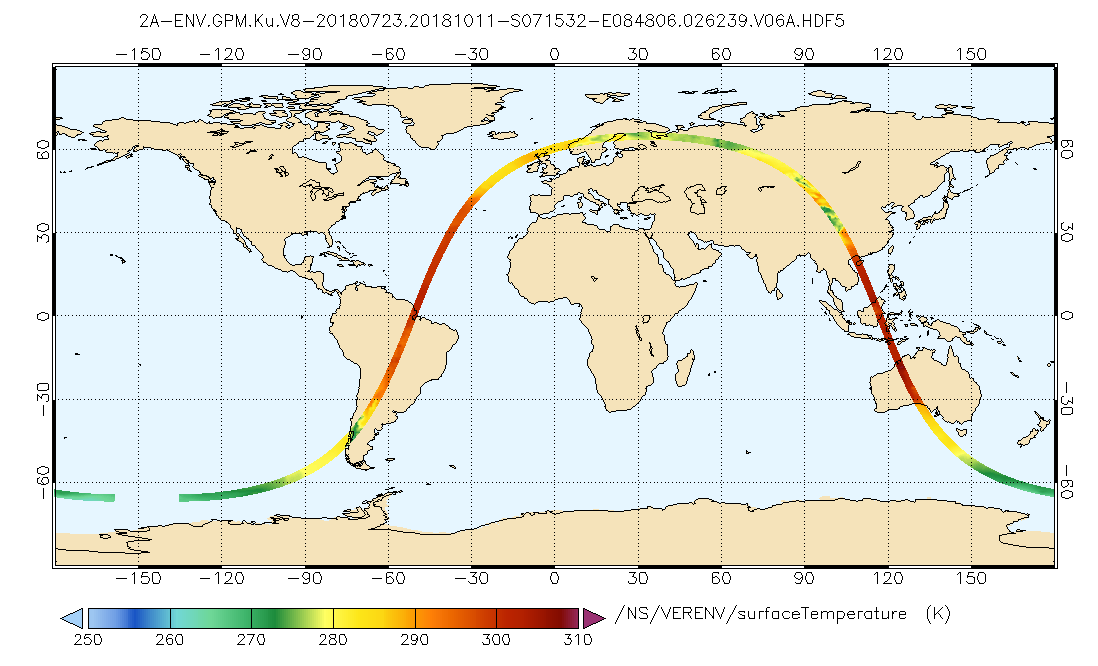
GPM DPR Ku Environment L2A 1.5 hours 5 km V07 (GPM_2AKuENV) at GES DISC
National Aeronautics and Space Administration —
Version 07 is the current version of the data set. Older versions will no longer be available and have been superseded by Version 07. . This is environmental data... -
Federal
SDG Indicator 9.1.1: Rural Access Index (RAI), 2023 Release
National Aeronautics and Space Administration —
The SDG Indicator 9.1.1: The Rural Access Index (RAI), 2023 Release data set, part of the SDGI collection, measures the proportion of the rural population who live... -
Federal
U.S. Social Vulnerability Index Grids, Revision 01
National Aeronautics and Space Administration —
The U.S. Social Vulnerability Index Grids, Revision 01 data set contains gridded layers for the overall Centers for Disease Control and Prevention (CDC) Social... -
Federal
Polar Ozone and Aerosol Measurement III
National Aeronautics and Space Administration —
POAM3 data are Polar Ozone and Aerosol Measurement III Version 3.0. The Polar Ozone and Aerosol Measurement (POAM) III instrument measures the vertical distribution... -
Federal
Population Exposure Estimates in Proximity to Nuclear Power Plants, Locations
National Aeronautics and Space Administration —
The Population Exposure Estimates in Proximity to Nuclear Power Plants, Locations data set combines information from a global data set developed by Declan Butler of... -
Federal
NOAA-21 VIIRS Global Binned Normalized Difference Vegetation Index Land Reflectance Data, version R2022.0
National Aeronautics and Space Administration —
The Visible and Infrared Imager/Radiometer Suite (VIIRS) is a multi-disciplinary instrument that is being flown on the Joint Polar Satellite System (JPSS) series of... -
Federal
IceBridge HiCARS 1 L2 Geolocated Ice Thickness V001
National Aeronautics and Space Administration —
This data set contains ice thickness, surface and bed elevation, and echo strength measurements taken over Antarctica using the Hi-Capability Airborne Radar Sounder... -
Federal
MLS/Aura Near-Real-Time L2 Temperature V005 (ML2T_NRT) at GES DISC
National Aeronautics and Space Administration —
ML2T_NRT is the EOS Aura Microwave Limb Sounder (MLS) Near-Real-Time (NRT) product for temperature. This product contains temperature profiles derived from the 118... -
Federal
Sentinel-1 Interferograms - Connected Components (BETA)
National Aeronautics and Space Administration —
Sentinel-1 SLC interferometric products generated by JPL using ISCE v2.0.0, delivered by ASF -
Federal
National Assessment of Oil and Gas Project - Powder River Basin Province (033) Regions of Oil and Gas Potential
Department of the Interior —
Regions of high or low potential for oil and gas resources in the Powder River Basin generally indicate where continuous oil and gas resources are more or less likely... -
Federal
A Concise Experiment Plan for the Arctic-Boreal Vulnerability Experiment
National Aeronautics and Space Administration —
This document presents the Concise Experiment Plan for NASA's Arctic-Boreal Vulnerability Experiment (ABoVE) to serve as a guide to the Program as it identifies the... -
Federal
AIRS/Aqua L1B Near Real Time (NRT) AMSU (A1/A2) geolocated and calibrated brightness temperatures V005 (AIRABRAD_NRT) at GES DISC
National Aeronautics and Space Administration —
The AMSU-A Level 1B Near Real Time (NRT) product (AIRABRAD_NRT_005) differs from the routine product (AIRABRAD_005) in 2 ways to meet the three hour latency... -
Federal
Millennium Ecosystem Assessment: MA Ecosystems
National Aeronautics and Space Administration —
The Millennium Ecosystem Assessment: MA Ecosystems provides data and information on the extent and classification of ecosystems circa 2000, including coastal,... -
Federal
Structure Contour of the Top of the Cotton Valley Group, Western Gulf and East Texas Basin and Louisiana-Mississippi Salt Basins Provinces (047, 048 and 049)
Department of the Interior —
This map shows the structural configuration on the top of the Cotton Valley Group in feet below sea level. The map was produced by calculating the difference between... -
Federal
Geologic Provinces of the Arabian Peninsula and adjacent areas, 2000 (prv2bg)
Department of the Interior —
This data set includes arcs, polygons, and polygon labels for geologic and petroleum provinces interpreted and designated by R.M. Pollastro based on numerous...

Official websites use .gov
A
.gov website belongs to an official government
organization in the United States.
Secure .gov websites use HTTPS
A
lock (
) or https:// means you’ve safely connected to
the .gov website. Share sensitive information only on official,
secure websites.