
-
Federal
AMSR-E/Aqua Daily L3 Global Ascending/Descending .25x.25 deg Ocean Grids V002
National Aeronautics and Space Administration —
The Level-3 daily product (AE_DyOcn), weekly product (AE_WkOcn), and monthly product (AE_MoOcn) include SST, near-surface wind speed, columnar water vapor, and... -
Federal
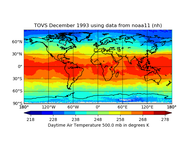
TOVS GLA DAILY GRIDS from NOAA-11 V01 (TOVSADNH) at GES DISC
National Aeronautics and Space Administration —
This dataset (TOVSADNH) contains the TIROS Operational Vertical Sounder (TOVS) level 3 geophysical parameters derived using data from NOAA-11 and the physical... -
Federal
International Comprehensive Ocean-Atmosphere Data Set (ICOADS) Near-Real-Time (NRT) Release 3.0.2, 2015 to Present
National Oceanic and Atmospheric Administration, Department of Commerce —
The International Comprehensive Ocean-Atmosphere Data Set (ICOADS) Near-Real-Time (NRT) product has been updated to a new version, Release 3.0.2. The new version... -
Federal
US Voluntary Observing Ship (VOS) - International Maritime Meteorological Tape (IMMT) data from TurboWin version 5.0 E-Logbook Software
National Oceanic and Atmospheric Administration, Department of Commerce —
The US Voluntary Observing Ships (VOS) report surface marine observations in both real-time (FM-13 ship format) and delayed-mode (International Maritime... -
Federal
Sentinel-5P TROPOMI SNPP VIIRS cloud product band 6 (NIR detector) 1-Orbit L2 5.5km x 3.5km V2 (S5P_L2__NP_BD6_HiR) at GES DISC
National Aeronautics and Space Administration —
Starting from August 6th in 2019, Sentinel-5P TROPOMI along-track high spatial resolution (~5.5km at nadir) has been implemented. For data before August 6th of 2019,... -
Federal
SBU Ceilometers IMPACTS V1
National Aeronautics and Space Administration —
The SBU Ceilometers IMPACTS dataset includes ceilometer cloud height measurements collected by the Vaisala CL51, Vaisala CT25K, and Lufft Ceilometer CHM 15k... -
Federal
GLAS/ICESat L2 Global Aerosol Vertical Structure Data (HDF5) V033
National Aeronautics and Space Administration —
GLAH10 Level-2 aerosol vertical structure data contain the attenuation-corrected cloud and aerosol backscatter and extinction profiles at a 4 sec sampling rate for... -
Federal
WDC-A Meteorological and Oceanographic Data from Chernobyl for 1986
National Oceanic and Atmospheric Administration, Department of Commerce —
WDCA Chernobyl Data consists of digital data set DSI-9681, archived at the National Centers for Environmental Information (NCEI). World Data Center for Meteorology... -
Federal
Level 2.0 Almucantar Inversion Products (except phase functions)
National Aeronautics and Space Administration —
AERONET inversion code provides aerosoloptical properties in the total atmospheric column derived from the direct and diffuse radiation measured byAERONETCimel... -
Federal
AMSR-E/Aqua L2B Global Swath Surface Precipitation GSFC Profiling Algorithm V004
National Aeronautics and Space Administration —
The AMSR-E/Aqua Level-2B precipitation product includes instantaneous surface precipitation rate and type over ice-free/snow-free land and ocean between 89.24 degrees... -
Federal
SatCORPS CERES GEO Edition 4 Meteosat-8 Southern Hemisphere Version 1.0
National Aeronautics and Space Administration —
CER_GEO_Ed4_MET08_SH_V01 is the Satellite Cloud and Radiation Property retrieval System (SatCORPS) Clouds and the Earth's Radiant Energy System (CERES) Geostationary... -
Federal
TRMM Microwave Imager Precipitation Profile L3 1 month 0.5 degree x 0.5 degree V7 (TRMM_3A12) at GES DISC
National Aeronautics and Space Administration —
The new equivalent for this dataset should be searched for as "GPM_3GPROFTRMMTMI_CLIM". This product contains global monthly means of surface precipitation rate, rain... -
Federal
TOVS GLA MONTHLY GRIDS from NOAA-11 02 (TOVSAMNH) at GES DISC
National Aeronautics and Space Administration —
This dataset (TOVSAMNH) contains the TIROS Operational Vertical Sounder (TOVS) level 3 geophysical parameters derived using data from NOAA-11 and the physical... -
Federal
International Satellite Cloud Climatology Project (ISCCP), Raw Radiance Data (B1)
National Oceanic and Atmospheric Administration, Department of Commerce —
In 1983, the International Satellite Cloud Climatology Project (ISCCP) began collecting satellite data from the international geostationary meteorological satellites... -
Federal
TRMM Microwave Imager Precipitation Profile L3 1 month 0.5 degree x 0.5 degree V7 (TRMM_3A12) at GES DISC
National Aeronautics and Space Administration —
The new equivalent for this dataset should be searched for as "GPM_3GPROFTRMMTMI_CLIM". This product contains global monthly means of surface precipitation rate, rain... -
Federal
TOVS LMD DAILY GRIDS from NOAA-10 V01 (TOVSBDNG) at GES DISC
National Aeronautics and Space Administration —
Level 3 parameters from HIRS/2 and MSU radiances using the Improved Initialization Inversion (3I) classification retrieval scheme by the Laboratoire de Meteorologie... -
Federal
TOVS GLA MONTHLY GRIDS from NOAA-8 02 (TOVSAMNE) at GES DISC
National Aeronautics and Space Administration —
This dataset (TOVSAMNE) contains the TIROS Operational Vertical Sounder (TOVS) level 3 geophysical parameters derived using data from NOAA-8 and the physical... -
Federal
NOAA GOES-R Series Advanced Baseline Imager (ABI) Level 2 Fog/Low Stratus (FLS)
National Oceanic and Atmospheric Administration, Department of Commerce —
The GOES-R Advanced Baseline Imager (ABI) Fog/Low Stratus (FLS) products contain estimates of low cloud/fog thickness and probabilities of reduced aviation visibility...

Official websites use .gov
A
.gov website belongs to an official government
organization in the United States.
Secure .gov websites use HTTPS
A
lock (
) or https:// means you’ve safely connected to
the .gov website. Share sensitive information only on official,
secure websites.