

330 datasets found
-
City
Directory Of Family Shelter Performance Ranking FY 2012 Q4 and 2013 Q1
City of New York —
List of Facilities, Providers and their Rankings for Q4 2012 and Q1 2013 -
Federal
Open-Ocean Shorelines for the Undeveloped Areas of New Jersey's Barrier Islands, Extracted from Orthoimagery, March 9, 1991 to July 30, 2013
Department of the Interior —
Assessing the physical change to shorelines and wetlands is critical in determining the resiliency of wetland systems that protect adjacent habitat and communities.... -
State
NAIP 2012 NDVI 1m California
State of California —
A Normalized Difference Vegetation Index (NDVI) was applied to the source NAIP 2012 imagery. NDVI=(NearIR-Red)/(NearIR+Red). The color ramp (produced by ESRI) goes... -
Federal
Collection Hearing Office Workload Data Collection
Social Security Administration —
A presentation of four key workload indicators (pending, receipts, dispositions and average processing time) for each hearing office in the Office of Hearings... -
State
i03 SystemwidePA 20101007
State of California —
This feature class represents the Systemwide Planning Area. It is one of the three Central Valley Flood Protection Plan (CVFPP) Planning Areas. It is comprised of the... -
State
i17 LeveeCenterlineClass 2012
State of California —
This line feature class represents levee centerlines for 93 Levee Maintenance Agencies/Reclamation Districts in the Sacramento-San Joaquin Delta. The centerline... -
State
Datasets of Bills Signed the Governor of the State of Oregon
State of Oregon —
This dataset contains links to the Datasets of Bills Signed by the Governor of the State of Oregon. -
Federal
Advanced Geothermal Drilling and Logging Technologies
Department of Energy —
The objective of advanced drilling and logging technologies is to promote ways and means to reduce the cost of geothermal drilling through an integrated effort which... -
Federal
Supporting Data QC Field Spikes SW NAWQA 2012-2015
Department of the Interior —
Field spikes were prepared at 207 stream and river sites as part of the U.S. Geological Survey (USGS) National Water Quality Assessment (NAWQA) project between... -
State
NAIP 2012 NDVI 1m California
State of California —
A Normalized Difference Vegetation Index (NDVI) was applied to the source NAIP 2012 imagery. NDVI=(NearIR-Red)/(NearIR+Red). The color ramp (produced by ESRI) goes... -
Federal
BLM Natl REA Middle Rockies Rapid Ecoregional Assessment (REA) Appendix E Conservation Elements Fine Filter 5-8 - December 2012
Department of the Interior —
The Rapid Ecoregional Assessments (REAs) were launched in 2010 to help improve the understanding of existing condition for ecoregions and how conditions may be... -
Federal
10 meter bathymetric grid of Barnegat Bay, New Jersey produced from trackline bathymetry collected by the U.S. Geological Survey in 2011, 2012, and 2013 (Esri binary grid, UTM 18N, WGS 84)
Department of the Interior —
Water quality in the Barnegat Bay-Little Egg Harbor estuary along the New Jersey coast is the focus of a multidisciplinary research project begun in 2011 by the U.S.... -
Federal
Annual Asian and Pacific Islander - Bilingual Employees
Social Security Administration —
This dataset displays our yearly national number of bi- or multilingual employees who volunteer their services as an interpreter and/or translator in their identified... -
Federal
Sediment sample locations and grain size results from samples collected in Barnegat Bay, NJ by the U.S. Geological Survey during 3 surveys in 2012 and 2013 (Esri point shapefile, Geographic, WGS 84)
Department of the Interior —
Water quality in the Barnegat Bay-Little Egg Harbor estuary along the New Jersey coast is the focus of a multidisciplinary research project begun in 2011 by the U.S.... -
Federal
Coastal Topography--Northeast Atlantic Coast, Post-Hurricane Sandy, 2012: Digital elevation model (DEM)
Department of the Interior —
A DEM was produced for a portion of the New York, Delaware, Maryland, Virginia, and North Carolina coastlines, post-Hurricane Sandy (Sandy was an October 2012... -
Federal
Sensitivity of Coastal Environments and Wildlife to Spilled Oil: Florida Panhandle: BIRDS (Bird Polygons)
National Oceanic and Atmospheric Administration, Department of Commerce —
This data set contains sensitive biological resource data for wading birds, shorebirds, waterfowl, raptors, diving birds, seabirds, passerine birds, and gulls and... -
Federal
Marine Fisheries Initiative Program (MARFIN) Exploratory surveys for red snapper juveniles off Florida South Atlantic coast from 2012-07-31 to 2012-09-08 (NCEI Accession 0156976)
National Oceanic and Atmospheric Administration, Department of Commerce —
The data set contains information on locations sampled, gears used, and whether red snapper were observed. If a red snapper was caught its total length was recorded. -
Federal
AMAPPS Southeast Aerial Cruise Spring 2012 at OBIS-SEAMAP
National Oceanic and Atmospheric Administration, Department of Commerce —
As part of the AMAPPS program, the Southeast Fisheries Science Center and the Northeast Fisheries Center conducted aerial surveys of continental shelf waters along... -
Federal
Southeast Region Headboat Survey-PPS Survey Design Project
National Oceanic and Atmospheric Administration, Department of Commerce —
This dataset is a record of trips selected during pilot procedures for the PPS design project designed to track the port agents ability to follow the PPS design and... -
Federal
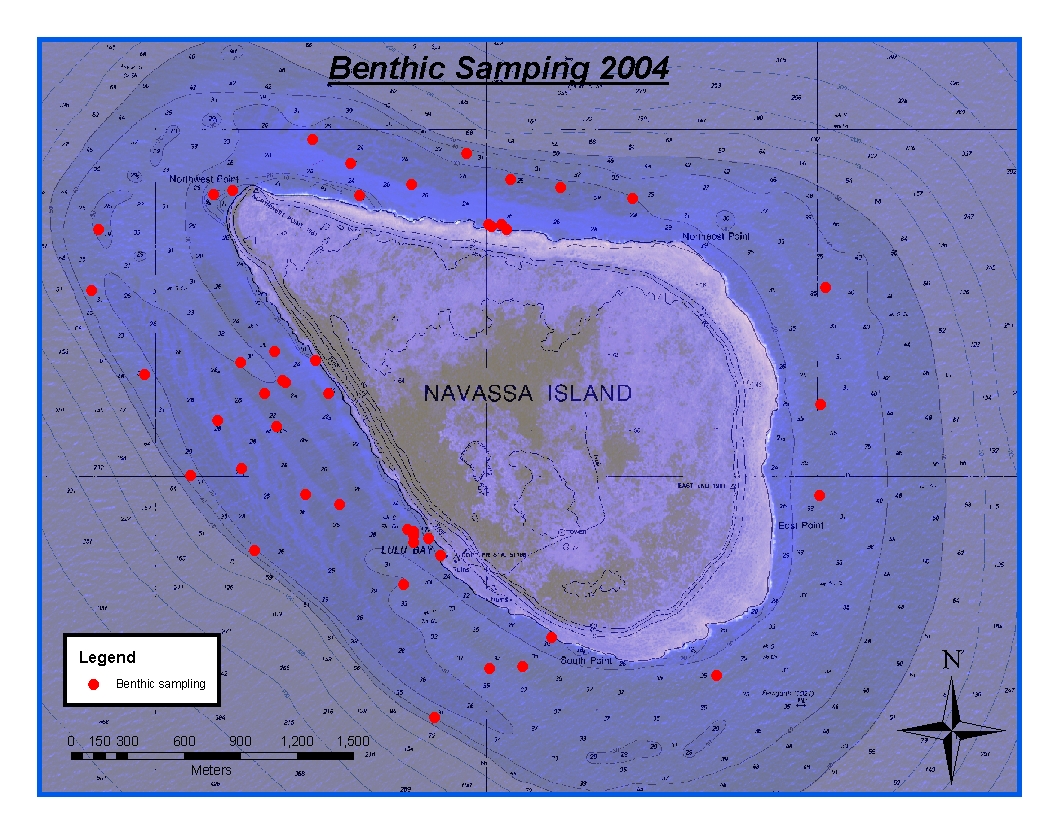
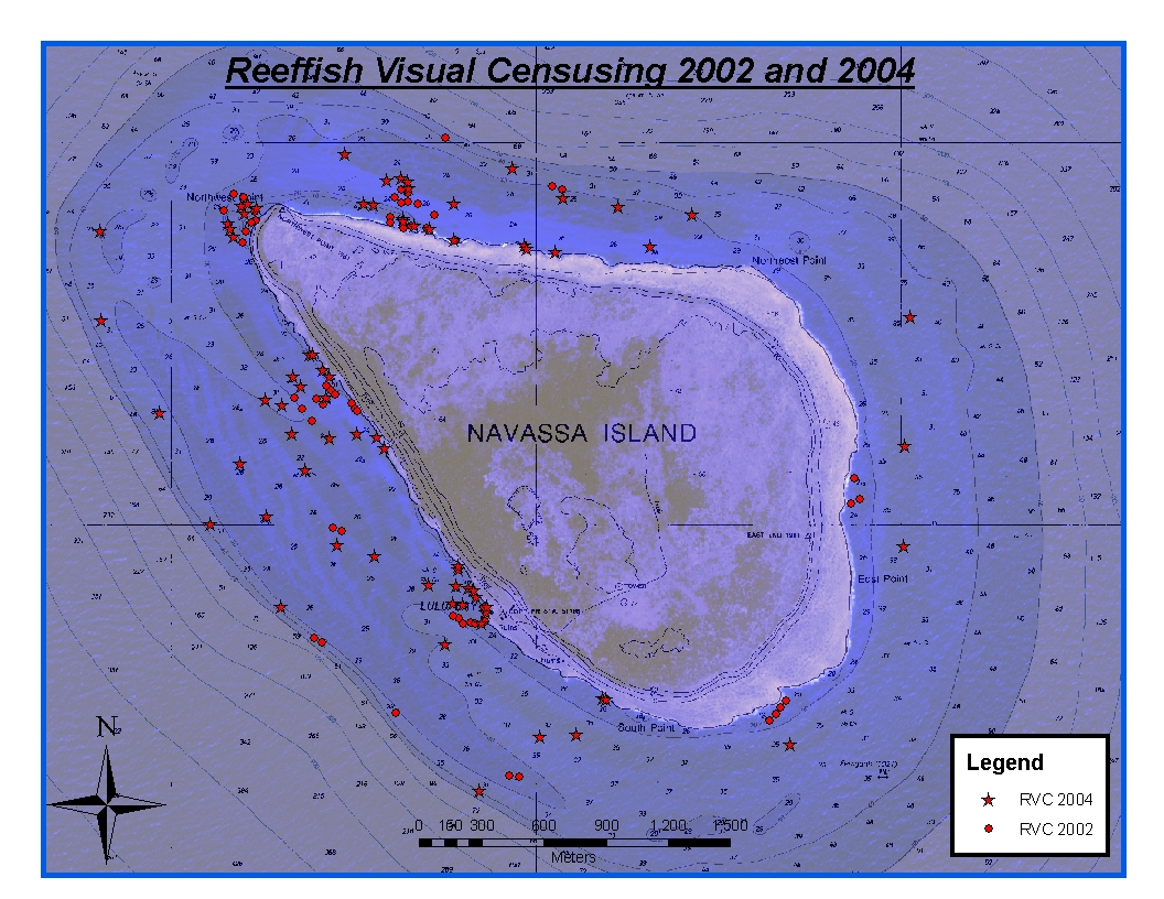
CRCP-Navassa reef assessment
National Oceanic and Atmospheric Administration, Department of Commerce —
Episodic cruises ( every 2 years) were conducted to perform assessments of Navassa Island coral reef resources including reeffish visual census, benthic reef...
330 datasets found