

382 datasets found
-
Federal
Utah FORGE: Deep Wells Water and Gas Sampling with Analyses by ThermoChem (October, 2022)
Department of Energy —
This data includes a document that describes the effort to collect and analyze water and gas samples from deep Utah FORGE wells 16A(78)-32, 58-32, 56-32 and 78B-32... -
Federal
CalWave WEC Open Water Demonstration - Public Final Test Report
Department of Energy —
The objective of this project is to advance the Technology Readiness Level of the x1 Wave Energy Converter (WEC) developed by CalWave Power Technologies Inc. through... -
Federal
Utah FORGE: 2022 Well Stimulation Seismicity Data Including SeGY Data
Department of Energy —
This is a link to the Utah FORGE seismic data distribution site hosted by the University of Utah Seismograph Stations. The data was collected from downhole geophone... -
Federal
GeoDAWN Northwestern Elko County Nevada EarthMRI Data
Department of Energy —
This submission includes both the original product resolution (OPR) and LiDAR point cloud (LPC) LiDAR data collected as part of GeoDAWN: Geoscience Data Acquisition... -
Federal
Processed continuous resistivity profile data collected in Manhasset Bay on Long Island, New York on May 17, 2008
Department of the Interior —
An investigation of coastal groundwater systems was performed along the north shore of Long Island, New York during May 2008 to constrain nutrient delivery to... -
Federal
Processed continuous resistivity profiling data collected in the Indian River Bay, Delaware, on April 15, 2010, on U.S. Geological Survey Field Activity 2010-006-FA
Department of the Interior —
A geophysical survey to delineate the fresh-saline groundwater interface and associated sub-bottom sedimentary structures beneath Indian River Bay, Delaware, was... -
Federal
Processed continuous resistivity profile (CRP) data below the sediment water interface from Manhasset Bay on Long Island, New York collected from May 15 to May 17, 2008 (MANHASSETALL_RESBELOWSED.SHP)
Department of the Interior —
An investigation of coastal groundwater systems was performed along the north shore of Long Island, New York during May 2008 to constrain nutrient delivery to... -
Federal
Sodar - Lubbock, TX - Processed Data
Department of Energy —
Overview This dataset was produced from the raw sodar .mnd files from the Lubbock, TX site during the WFIP1 campaign. Quality control and formatting... -
Federal
Sodar - Reagan, TX - Processed Data
Department of Energy —
Overview This dataset was produced from the raw sodar .dat files from the Reagan, TX site during the WFIP1 campaign. Quality control and formatting... -
Federal
Version 2 - Tidal Energy Resource Characterization, Velocity and Turbulence Measurements, Cook Inlet, AK, 2021
Department of Energy —
Version 2 of MHKDR submission #475, which also contains the metadata for these measurements. Files here are stored in netCDF4 format, which can be read in Python... -
Federal
Point shapefile of processed continuous resistivity profiling data below the sediment water interface collected in the Indian River Bay, Delaware, on April 15, 2010, on U.S. Geological Survey Field Activity 2010-006-FA (MRGAPR15_ALLXYZRES.SHP, Geographic, WGS 84)
Department of the Interior —
A geophysical survey to delineate the fresh-saline groundwater interface and associated sub-bottom sedimentary structures beneath Indian River Bay, Delaware, was... -
Federal
RES2DINV format continuous resistivity profile data collected in Manhasset Bay on Long Island, New York on May 15, 2008
Department of the Interior —
An investigation of coastal groundwater systems was performed along the north shore of Long Island, New York during May 2008 to constrain nutrient delivery to... -
Federal
Sodar - Vaisala Triton Wind Profiler, AON9 - Processed Data
Department of Energy —
Overview This dataset contains measurements from eight different Vaisala Triton Wind Profiler instruments. The Triton Wind Profiler is a sodar wind... -
Federal
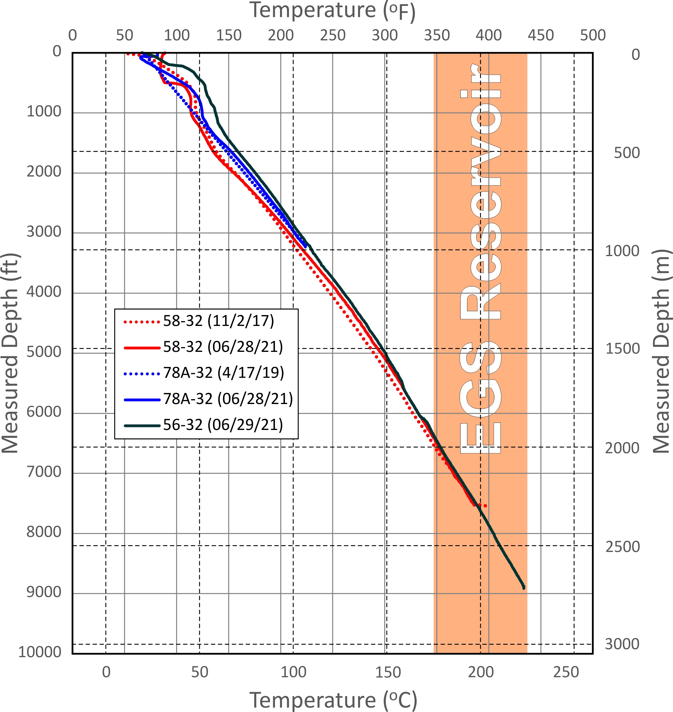
Utah FORGE: Wells Updated Temperature and Pressure Logs (June 2021)
Department of Energy —
This dataset includes updated temperature and pressure logs for Utah FORGE wells 56-32, 78-32, and 58-32. This data was acquired in June 2021. -
Federal
Wave Measurements taken NW of Culebra Island, Puerto Rico, 2023
Department of Energy —
Wave and sea surface temperature measurements collected by a Sofar Spotter buoy in 2023. The buoy was deployed on July 27, 2023 at 11:30 UTC northwest of Culebra... -
Federal
DAISY Acoustic Measurements in Agate Pass, WA
Department of Energy —
Acoustic data and metadata from Drifting Acoustic Instrumentation SYstem (DAISY) testing in Agate Pass (separating the north end of Bainbridge Island and the Kitsap... -
Federal
Processed Continuous Resistivity Profile Data Collected in the Corsica River Estuary, Maryland on May 17, 2007 on USGS Cruise 07005
Department of the Interior —
Submarine groundwater discharge (SGD) into Maryland's Corsica River Estuary was investigated as part of a larger study to determine the importance of nutrient... -
Federal
RES2DINV format continuous resistivity profile data collected in Manhasset Bay on Long Island, New York on May 17, 2008
Department of the Interior —
An investigation of coastal groundwater systems was performed along the north shore of Long Island, New York during May 2008 to constrain nutrient delivery to... -
Federal
Commercial Reference Building: Small Office
Department of Energy —
Commercial reference buildings provide complete descriptions for whole building energy analysis using EnergyPlus (see "About EnergyPlus" resource link) simulation...
382 datasets found