
-
Federal
NOAA/WDS Paleoclimatology - Northern Hemisphere 1000 Year Multiproxy Temperature Reconstruction
National Oceanic and Atmospheric Administration, Department of Commerce —
This archived Paleoclimatology Study is available from the NOAA National Centers for Environmental Information (NCEI), under the World Data Service (WDS) for... -
Federal
NOAA/WDS Paleoclimatology - Globally Resolved Surface Temperatures Since the Last Glacial Maximum
National Oceanic and Atmospheric Administration, Department of Commerce —
This archived Paleoclimatology Study is available from the NOAA National Centers for Environmental Information (NCEI), under the World Data Service (WDS) for... -
Federal
Hurricane Hugo Poster (September 21, 1989)
National Oceanic and Atmospheric Administration, Department of Commerce —
Hurricane Hugo poster. Multi-spectral image from NOAA-11 captures Hurricane Hugo slamming into South Carolina coast on September 21, 1989. Poster size is 36"x36". -
Federal
F00757: NOS Hydrographic Survey , 2018-11-01
National Oceanic and Atmospheric Administration, Department of Commerce —
The National Oceanic and Atmospheric Administration (NOAA) has the statutory mandate to collect hydrographic data in support of nautical chart compilation for safe... -
Federal
Kawaihae, Hawaii Tsunami Forecast Grids for MOST Model
National Oceanic and Atmospheric Administration, Department of Commerce —
The Kawaihae, Hawaii Forecast Model Grids provides bathymetric data strictly for tsunami inundation modeling with the Method of Splitting Tsunami (MOST) model. MOST... -
Federal
D00239: NOS Hydrographic Survey , 2017-09-15
National Oceanic and Atmospheric Administration, Department of Commerce —
The National Oceanic and Atmospheric Administration (NOAA) has the statutory mandate to collect hydrographic data in support of nautical chart compilation for safe... -
Federal
Continuously Updated Digital Elevation Model (CUDEM) - 1/3 Arc-Second Resolution Bathymetric-Topographic Tiles NGDA
National Oceanic and Atmospheric Administration, Department of Commerce —
NOAA's National Centers for Environmental Information (NCEI) is developing a suite of digital elevation models (DEMs) for the U.S. coast to support a variety of NOAA... -
Federal
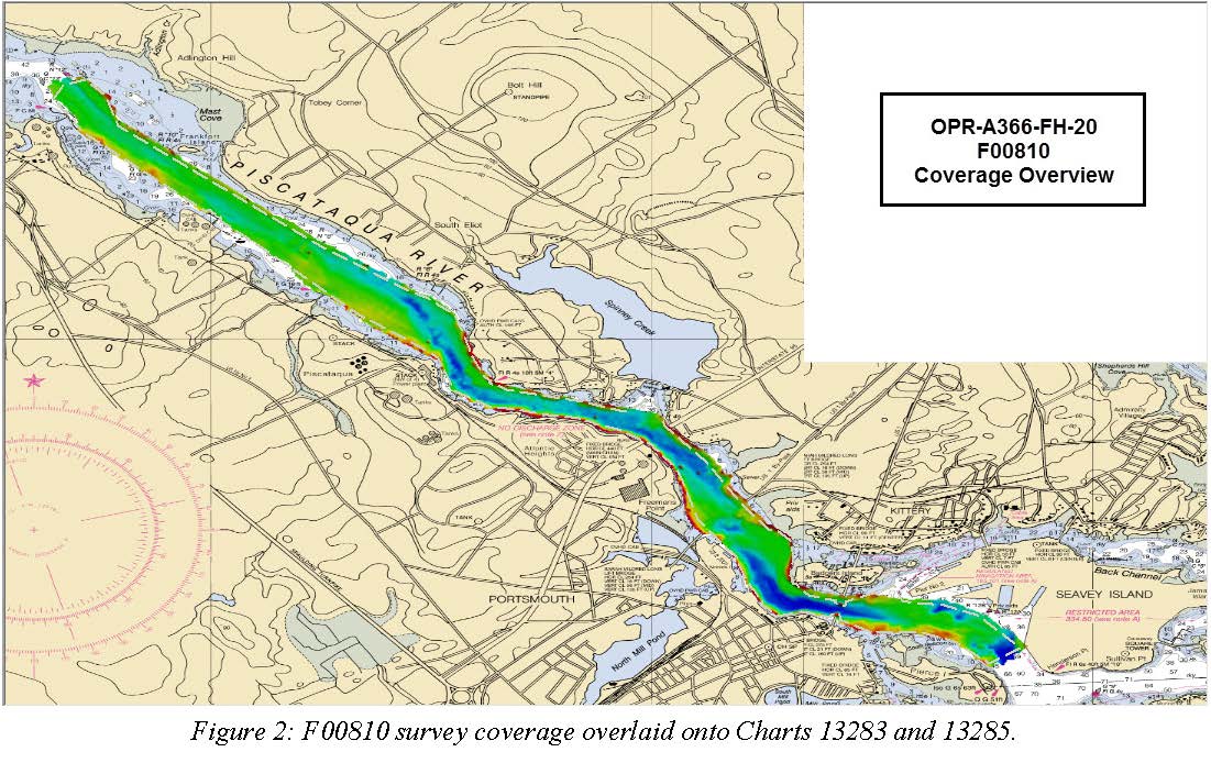
F00810: NOS Hydrographic Survey , 2020-08-05
National Oceanic and Atmospheric Administration, Department of Commerce —
The National Oceanic and Atmospheric Administration (NOAA) has the statutory mandate to collect hydrographic data in support of nautical chart compilation for safe... -
Federal
NOAA/WDS Paleoclimatology - Holmes - Frederick Butte - JUOC - OR015, PAGES North America 2K Version
National Oceanic and Atmospheric Administration, Department of Commerce —
This archived Paleoclimatology Study is available from the NOAA National Centers for Environmental Information (NCEI), under the World Data Service (WDS) for... -
Federal
Mount Pinatubo Revisited; A Study of Lahar Erosion
National Oceanic and Atmospheric Administration, Department of Commerce —
At dawn on June 15, 1991, a cataclysmic eruption began with a tremendous explosion that destroyed ten deserted villages. This eruption deposited approximately 5 to 7... -
Federal
Enhanced Magnetic Model 2015
National Oceanic and Atmospheric Administration, Department of Commerce —
The Enhanced Magnetic Model (EMM) extends to degree and order 720, resolving magnetic anomalies down to 56 km wavelength. The higher resolution of the EMM results in... -
Federal
2004 Landfalling Hurricanes Poster
National Oceanic and Atmospheric Administration, Department of Commerce —
The 2004 U.S. Landfalling Hurricanes poster is a special edition poster which contains two sets of images of Hurricanes Charley, Frances, Ivan, and Jeanne, created... -
Federal
CO-OPS station 8761927: USCG NEW CANAL STA., LAKE PONTCHARTRAIN 1-minute Raw Tsunami Water Level Data
National Oceanic and Atmospheric Administration, Department of Commerce —
CO-OPS has been involved with tsunami warning and mitigation since the Coast and Geodetic Survey started the Tsunami Warning System in 1948 to provide warnings to the... -
Federal
H07741: NOS Hydrographic Survey , 1949-12-31
National Oceanic and Atmospheric Administration, Department of Commerce —
The National Oceanic and Atmospheric Administration (NOAA) has the statutory mandate to collect hydrographic data in support of nautical chart compilation for safe... -
Federal
H00133A: NOS Hydrographic Survey , 1841-10-19
National Oceanic and Atmospheric Administration, Department of Commerce —
The National Oceanic and Atmospheric Administration (NOAA) has the statutory mandate to collect hydrographic data in support of nautical chart compilation for safe... -
Federal
H06103: NOS Hydrographic Survey , 1936-12-31
National Oceanic and Atmospheric Administration, Department of Commerce —
The National Oceanic and Atmospheric Administration (NOAA) has the statutory mandate to collect hydrographic data in support of nautical chart compilation for safe... -
Federal
H04729: NOS Hydrographic Survey , 1927-12-31
National Oceanic and Atmospheric Administration, Department of Commerce —
The National Oceanic and Atmospheric Administration (NOAA) has the statutory mandate to collect hydrographic data in support of nautical chart compilation for safe... -
Federal
F00036: NOS Hydrographic Survey , 1942-07-12
National Oceanic and Atmospheric Administration, Department of Commerce —
The National Oceanic and Atmospheric Administration (NOAA) has the statutory mandate to collect hydrographic data in support of nautical chart compilation for safe... -
Federal
High-Resolution Seismic Profiles from the US Atlantic Continental Margin Atlantic
National Oceanic and Atmospheric Administration, Department of Commerce —
Knudsen 320BR CHIRP subbottom data collected simultaneously with multibeam bathymetry and acoustic backscatter. -
Federal
Multibeam collection for SKQ201701S: Multibeam data collected aboard Sikuliaq from 19-Jan-17 to 15-Feb-17, Manzanillo, Mexico to San Diego, California
National Oceanic and Atmospheric Administration, Department of Commerce —
This data set is part of a larger set of data called the Multibeam Bathymetry Database (MBBDB) where other similar data can be found

Official websites use .gov
A
.gov website belongs to an official government
organization in the United States.
Secure .gov websites use HTTPS
A
lock (
) or https:// means you’ve safely connected to
the .gov website. Share sensitive information only on official,
secure websites.