
-
Federal
Shorelines Extracted from 1984-2015 Landsat Imagery: Cat Island, Mississippi (Polygon: Combined Dates)
Department of the Interior —
Shorelines Extracted from 1984-2015 Landsat Imagery: Cat Island, Mississippi (Polygon: Combined Dates) is a polygon shapefile representing shorelines generated from... -
Federal
EAARL Coastal Topography--Cape Hatteras National Seashore, North Carolina, Post-Nor'Ida, 2009: Bare Earth
Department of the Interior —
A digital elevation model (DEM) of a portion of the Cape Hatteras National Seashore in North Carolina, post-Nor'Ida (November 2009 nor'easter), was produced from... -
Federal
Shorelines Extracted from 1984-2015 Landsat Imagery: Dauphin Island, Alabama (Polygon: Individual Dates)
Department of the Interior —
Shorelines Extracted from 1984-2015 Landsat Imagery: Dauphin Island, Alabama (Polygon: Individual Dates) is a dataset consisting of 223 polygon shapefiles... -
Federal
Characterizing freshwater and nutrient fluxes to West Falmouth Harbor, Massachusetts
Department of the Interior —
These data present oceanographic and water-quality observations made at 4 locations in West Falmouth Harbor and 3 in Buzzards Bay, Massachusetts. While both Buzzards... -
State
NAIP 2009 NDVI 1m California
State of California —
A Normalized Difference Vegetation Index (NDVI) was applied to the source NAIP 2009 imagery. NDVI=(NearIR-Red)/(NearIR+Red). The color ramp (produced by ESRI) goes... -
Federal
Bathymetry Coverage for 2008 and 2009
Department of the Interior —
For the Jamaica Bay Bathymetry project, data was collected over 3 different years using different instruments and scales. This shapefile shows the coverage for the... -
Federal
Shorelines Extracted from 1984-2015 Landsat Imagery: Petit Bois Island, Mississippi (Polyline: Combined Dates)
Department of the Interior —
Shorelines Extracted from 1984-2015 Landsat Imagery: Petit Bois Island, Mississippi (Polyline: Combined Dates) is a line shapefile representing shorelines generated... -
Federal
NOAA TIFF Image - 10m Bathymetric Rugosity, South Atlantic Bight - Deep Coral Priority Areas - NOAA Ship Nancy Foster - (2009), UTM 17N NAD83
National Oceanic and Atmospheric Administration, Department of Commerce —
This dataset contains a unified GeoTiff with 10x10 meter cell size representing the rugosity of several deep coral priority areas off the South Atlantic Bight,... -
Federal
SSI Recipients by State and County - 2009
Social Security Administration —
An annual statistical report on the Supplemental Security Income program that provides tables on program recipients, federal payments, and federally administered... -
Federal
Average Processing Time Until Hearing Held - FY 1989-2009
Social Security Administration —
This dataset provides historical data for average wait time (in days) from the hearing request date until a hearing was held. This dataset includes data from fiscal... -
Federal
OASDI Beneficiaries by State and County - 2009
Social Security Administration —
This annual publication focuses on the Social Security beneficiary population receiving Old-Age, Survivors, and Disability Insurance (OASDI) benefits at the local... -
Federal
Coastal Resources Atlas: Long Island: MGT (Management Area Polygons)
National Oceanic and Atmospheric Administration, Department of Commerce —
This data set contains human-use data for management areas, National Park Service properties, State Parks, and National Wildlife Refuges in Long Island, New York.... -
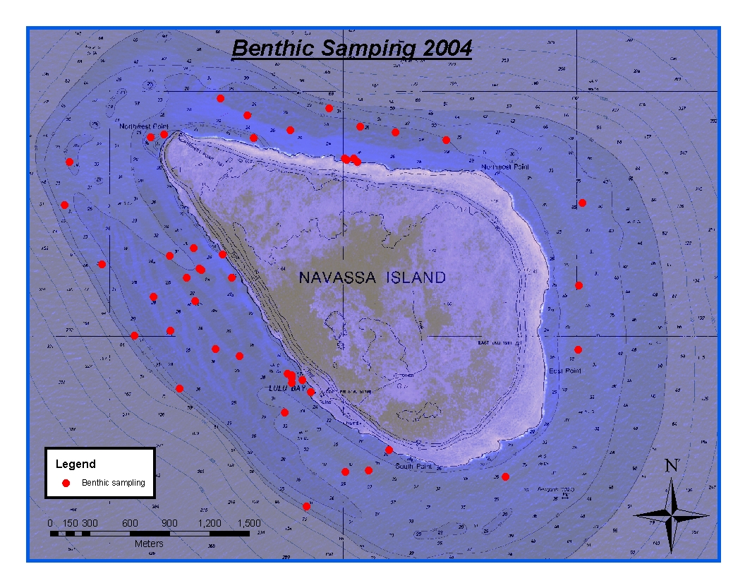
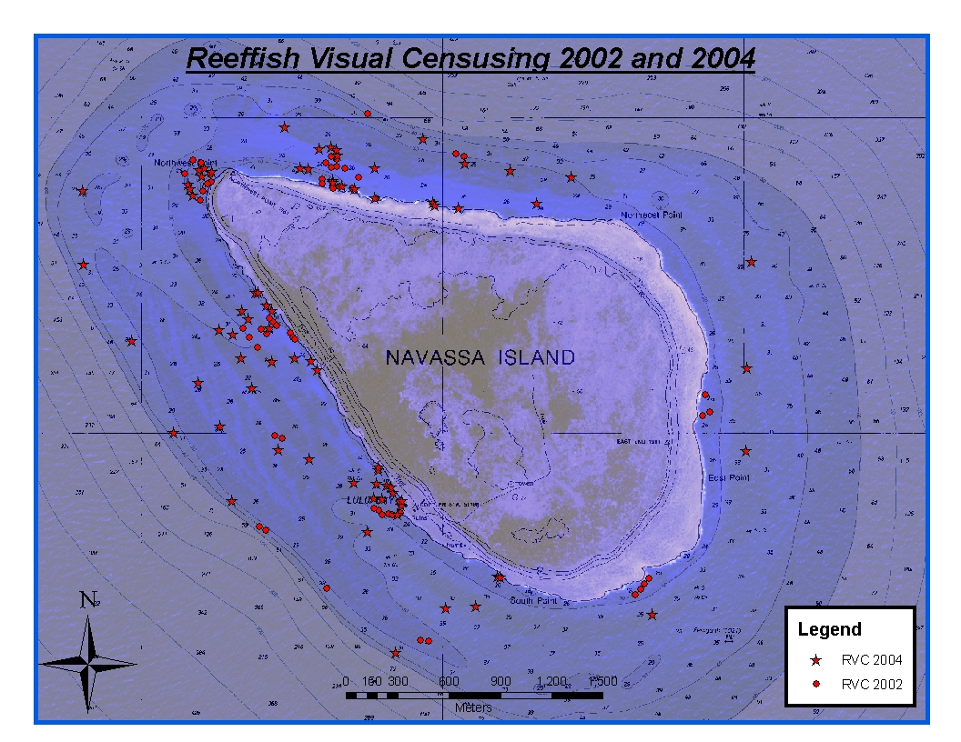
Federal
CRCP-Navassa reef assessment
National Oceanic and Atmospheric Administration, Department of Commerce —
Episodic cruises ( every 2 years) were conducted to perform assessments of Navassa Island coral reef resources including reeffish visual census, benthic reef... -
Federal
Appeals Council Requests - Average Processing Time - FY 1989-2016
Social Security Administration —
This dataset provides annual data from 1989 through 2016 for the average processing time (elapsed time in days) for dispositions by the Appeals Council (AC) (both... -
Federal
Bathymetric Terrain Model of the U.S. Atlantic Margin (100-meter resolution) compiled by the U.S. Geological Survey (32-bit GeoTIFF, MERCATOR Projection, WGS 84)
Department of the Interior —
Bathymetric terrain models of seafloor morphology are an important component of marine geological investigations. Advances in acquisition and processing technologies... -
Federal
NOAA TIFF Image - 3x3m Multibeam Backscatter, US Virgin Islands - Vieques Island (South Bank) - Project NF-09-01 - (2009), UTM 20N NAD83 (NCEI Accession 0131857)
National Oceanic and Atmospheric Administration, Department of Commerce —
This dataset contains a GeoTIFF with 3x3 meter cell size representing the backscatter or intensity of sound returned from the seafloor on the bank/shelf escarpment... -
State
Eelgrass Beds 2009 Set
State of Connecticut —
Eelgrass Beds 2009 Set: This data layer was created by the Conservation Management Institute, Virginia Tech University for the USFWS National Wetlands Inventory,... -
Federal
National 800 Number Network - Average Speed to Answer
Social Security Administration —
This data file provides information at the national level by month for federal fiscal years 2007 on for average speed to answer for calls to the National 800 Number... -
Federal
Bathymetry Coverage 2003, 2008, 2009
Department of the Interior —
To show the full extent of all of the data collected for this project. This includes 2003, 2008, and 2009 -
Federal
Coastal Resources Atlas: Long Island: INVERT (Invertebrate Polygons)
National Oceanic and Atmospheric Administration, Department of Commerce —
This data set contains sensitive biological resource data for coastal, estuarine, and marine invertebrate species for Long Island, New York. Vector polygons in this...

Official websites use .gov
A
.gov website belongs to an official government
organization in the United States.
Secure .gov websites use HTTPS
A
lock (
) or https:// means you’ve safely connected to
the .gov website. Share sensitive information only on official,
secure websites.